TopoQuest Logo
Do you find TopoQuest useful?
Help keep TopoQuest running and adding new maps/features by donating!
Bitcoin:  19c7KJd3qBynnjoSw5npx9KScwjBe4ifkT
Litecoin:  LXs6TkuXGGXo1vDsWCkWVdjQX94eUKd6ui
Home View Maps Find Maps Find Places Resources & Links


Avery, Arkansas Topographic Map

USGS Map Title: Avery, AR
USGS Map MRC: 33091H6
DRG (GeoTIFF) Download: o33091h6.tif


Neighboring USGS Topographic Map Quads:


  Tarry, AR  
34091A7
 

  Grady, AR  
34091A6
 

  Cades, AR  
34091A5
 

  Star City, AR  
33091H7
 

  Avery, AR  
33091H6
 

  Gould, AR  
33091H5
 

  Relfs Bluff, AR  
33091G7
 

  Tyro, AR  
33091G6
 

  Gourd, AR  
33091G5


Map MRC Location:

N34°
W92°
N34°
W91°
H8 H7 H6 H5 H4 H3 H2 H1
G8 G7 G6 G5 G4 G3 G2 G1
F8 F7 F6 F5 F4 F3 F2 F1
E8 E7 E6 E5 E4 E3 E2 E1
D8 D7 D6 D5 D4 D3 D2 D1
C8 C7 C6 C5 C4 C3 C2 C1
B8 B7 B6 B5 B4 B3 B2 B1
A8 A7 A6 A5 A4 A3 A2 A1
N33°
W92°
N33°
W91°

Avery, AR USGS 1:24K Topographic Map Preview:
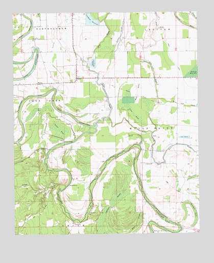
Avery, AR USGS Topographic Map
Click on map above to begin viewing in our Map Viewer.

This topographic map contains these locations and features:
Feature Name Type Latitude Longitude GNIS ID View Map
AveryPopulated PlaceN33.9298°W91.6571°57296View Map
Avery BrakeSwampN33.9428°W91.6683°45987View Map
Cane CreekStreamN33.9270°W91.7476°47380View Map
Caney CreekStreamN33.9248°W91.6657°47404View Map
Champion (historical)Populated PlaceN33.9479°W91.6501°66867View Map
Coles Spur (historical)LocaleN33.9609°W91.7085°64048View Map
Cypress Grove ChurchChurchN33.9026°W91.7129°48316View Map
Dark BrakeSwampN33.8946°W91.6466°64051View Map
Deep BayouStreamN33.9354°W91.6951°48440View Map
Flag PondSwampN33.9159°W91.6296°64055View Map
FresnoPopulated PlaceN33.9632°W91.7071°57021View Map
Gibson BrakeSwampN33.9340°W91.7188°49393View Map
Harm Coat BayouLakeN33.9523°W91.6531°49863View Map
Horseshoe BrakeSwampN33.8866°W91.6345°50339View Map
Liberty ChurchChurchN33.9620°W91.7071°64067View Map
Lincoln CountyCivilN33.9575°W91.7333°66873View Map
Mackwee CemeteryCemeteryN33.9051°W91.6640°51593View Map
Mackwee Church (historical)ChurchN33.9051°W91.6643°64068View Map
Mattox Ferry (historical)CrossingN33.9973°W91.7399°64069View Map
Mattox FordCrossingN33.9973°W91.7399°64070View Map
MeroneyPopulated PlaceN33.9604°W91.7340°57113View Map
Mills SloughGutN33.8809°W91.6674°52083View Map
Mount Olive ChurchChurchN33.9857°W91.7354°52344View Map
New Bethel Church (historical)ChurchN33.9315°W91.6665°64076View Map
Panther SloughLakeN33.9867°W91.6773°53170View Map
Persons BridgeLocaleN33.9273°W91.7162°53296View Map
Persons Bridge School (historical)SchoolN33.9268°W91.7187°64082View Map
Persons ChapelChurchN33.9234°W91.7321°53297View Map
Persons Chapel School (historical)SchoolN33.9232°W91.7324°64083View Map
Pinchback ReservoirReservoirN33.9957°W91.6971°70368View Map
Price Brake (historical)SwampN33.9154°W91.6376°64085View Map
Purtris BrakeSwampN33.9180°W91.6990°64086View Map
Purtris BrakeSwampN33.9219°W91.7151°53854View Map
Rankin Chapel Baptist ChurchChurchN33.9718°W91.6612°78134View Map
Rose HillPopulated PlaceN33.8865°W91.6996°64090View Map
Rose Hill ChurchChurchN33.8870°W91.6993°54205View Map
Saint Harmony ChurchChurchN33.9145°W91.6568°54334View Map
Saint James Church (historical)ChurchN33.9598°W91.7426°64092View Map
Shooks ReservoirReservoirN33.9698°W91.6965°70377View Map
Village CreekStreamN33.9020°W91.7154°55911View Map
Wagon BayouStreamN33.9837°W91.6468°55939View Map
Wells Bayou SchoolSchoolN33.9212°W91.6537°56143View Map
Wells Bayou Volunteer Fire DepartmentBuildingN33.9251°W91.6417°2117288View Map

Note: Coordinates in the location and feature list above are referenced to NAD83 datum.


Copyright (C) 2008-2025 Ryan Niemi / Sunset Dynamics ... All Rights Reserved