TopoQuest Logo
Do you find TopoQuest useful?
Help keep TopoQuest running and adding new maps/features by donating!
Bitcoin:  19c7KJd3qBynnjoSw5npx9KScwjBe4ifkT
Litecoin:  LXs6TkuXGGXo1vDsWCkWVdjQX94eUKd6ui
Home View Maps Find Maps Find Places Resources & Links


Selma, Arkansas Topographic Map

USGS Map Title: Selma, AR
USGS Map MRC: 33091F5
DRG (GeoTIFF) Download: o33091f5.tif


Neighboring USGS Topographic Map Quads:


  Tyro, AR  
33091G6
 

  Gourd, AR  
33091G5
 

  Winchester, AR  
33091G4
 

  Collins NW, AR  
33091F6
 

  Selma, AR  
33091F5
 

  McGehee North, AR  
33091F4
 

  Cominto, AR  
33091E6
 

  Collins, AR  
33091E5
 

  McGehee South, AR  
33091E4


Map MRC Location:

N34°
W92°
N34°
W91°
H8 H7 H6 H5 H4 H3 H2 H1
G8 G7 G6 G5 G4 G3 G2 G1
F8 F7 F6 F5 F4 F3 F2 F1
E8 E7 E6 E5 E4 E3 E2 E1
D8 D7 D6 D5 D4 D3 D2 D1
C8 C7 C6 C5 C4 C3 C2 C1
B8 B7 B6 B5 B4 B3 B2 B1
A8 A7 A6 A5 A4 A3 A2 A1
N33°
W92°
N33°
W91°

Selma, AR USGS 1:24K Topographic Map Preview:
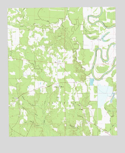
Selma, AR USGS Topographic Map
Click on map above to begin viewing in our Map Viewer.

This topographic map contains these locations and features:
Feature Name Type Latitude Longitude GNIS ID View Map
Ables CreekStreamN33.6868°W91.5285°76150View Map
Caney BranchStreamN33.7207°W91.5546°47396View Map
Casper BranchStreamN33.6396°W91.5846°47516View Map
Dabney CemeteryCemeteryN33.6548°W91.5423°48324View Map
Dishongh CemeteryCemeteryN33.6632°W91.5693°48522View Map
Horseshoe BrakeSwampN33.7179°W91.5086°77227View Map
Lower Cutoff CreekStreamN33.7051°W91.6246°51499View Map
Mink Track BrakeSwampN33.7267°W91.5336°77673View Map
New Bethem ChurchChurchN33.7187°W91.5179°77808View Map
Oak Grove Methodist Episcopal Zion ChurchChurchN33.6512°W91.5396°77876View Map
Panther CreekStreamN33.7368°W91.5657°53155View Map
Poff BrakeSwampN33.6256°W91.5061°53637View Map
Prairie CreekStreamN33.7359°W91.6007°53764View Map
Pres Allen BranchStreamN33.6382°W91.5848°53783View Map
Red SloughGutN33.6409°W91.5079°53959View Map
Section BrakeSwampN33.6498°W91.5121°54661View Map
SelmaPopulated PlaceN33.6973°W91.5676°57184View Map
Selma CemeteryCemeteryN33.7043°W91.5737°79090View Map
Selma Junior High SchoolSchoolN33.6732°W91.5660°54668View Map
Selma School (historical)SchoolN33.6946°W91.5676°79091View Map
Selma Volunteer Fire DepartmentBuildingN33.6952°W91.5684°2117106View Map
Sixteen Section CemeteryCemeteryN33.6568°W91.6137°78374View Map
Sixteenth SectionPopulated PlaceN33.6626°W91.6140°79096View Map
Sixteenth Section Missionary Baptist ChurchChurchN33.6623°W91.6143°78375View Map
Sweet Home Baptist ChurchChurchN33.6729°W91.5671°78514View Map
Township of FranklinCivilN33.6621°W91.5388°66514View Map
Township of Live OakCivilN33.7439°W91.5778°66515View Map
Trotters BrakeSwampN33.7204°W91.5281°78585View Map
Troublesome BranchStreamN33.6282°W91.5451°55660View Map
Upper Cutoff CreekStreamN33.7054°W91.6246°55853View Map
Wells LakeReservoirN33.7034°W91.5868°81276View Map
Wells Lake DamDamN33.7034°W91.5868°81275View Map
Whittaker BranchStreamN33.6521°W91.5871°56334View Map

Note: Coordinates in the location and feature list above are referenced to NAD83 datum.


Copyright (C) 2008-2024 Ryan Niemi / Sunset Dynamics ... All Rights Reserved