TopoQuest Logo
Do you find TopoQuest useful?
Help keep TopoQuest running and adding new maps/features by donating!
Bitcoin:  19c7KJd3qBynnjoSw5npx9KScwjBe4ifkT
Litecoin:  LXs6TkuXGGXo1vDsWCkWVdjQX94eUKd6ui
Home View Maps Find Maps Find Places Resources & Links


Attica, Indiana Topographic Map

USGS Map Title: Attica, IN
USGS Map MRC: 40087C2
DRG (GeoTIFF) Download: o40087c2.tif


Neighboring USGS Topographic Map Quads:


  Pine Village, IN  
40087D3
 

  Chatterton, IN  
40087D2
 

  Otterbein, IN  
40087D1
 

  Williamsport, IN  
40087C3
 

  Attica, IN  
40087C2
 

  Westpoint, IN  
40087C1
 

  Stone Bluff, IN  
40087B3
 

  Mellott, IN  
40087B2
 

  Wingate, IN  
40087B1


Map MRC Location:

N41°
W88°
N41°
W87°
H8 H7 H6 H5 H4 H3 H2 H1
G8 G7 G6 G5 G4 G3 G2 G1
F8 F7 F6 F5 F4 F3 F2 F1
E8 E7 E6 E5 E4 E3 E2 E1
D8 D7 D6 D5 D4 D3 D2 D1
C8 C7 C6 C5 C4 C3 C2 C1
B8 B7 B6 B5 B4 B3 B2 B1
A8 A7 A6 A5 A4 A3 A2 A1
N40°
W88°
N40°
W87°

Attica, IN USGS 1:24K Topographic Map Preview:
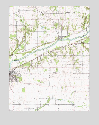
Attica, IN USGS Topographic Map
Click on map above to begin viewing in our Map Viewer.

This topographic map contains these locations and features:
Feature Name Type Latitude Longitude GNIS ID View Map
AtticaPopulated PlaceN40.2942°W87.2489°430330View Map
Attica Fire DepartmentBuildingN40.2925°W87.2470°2701355View Map
Attica Police DepartmentBuildingN40.2929°W87.2469°2758231View Map
Attica Volunteer Fire DepartmentBuildingN40.2926°W87.2470°2625862View Map
Banning CornerPopulated PlaceN40.3664°W87.1625°430474View Map
Bethel CemeteryCemeteryN40.3523°W87.2447°430897View Map
Bethel ChurchChurchN40.2961°W87.1775°430908View Map
City of AtticaCivilN40.2876°W87.2449°2394018View Map
Clark CemeteryCemeteryN40.3198°W87.1772°432553View Map
Clawson DitchCanalN40.3689°W87.1811°432583View Map
Davis PondReservoirN40.3741°W87.1977°452439View Map
Dry BranchStreamN40.3417°W87.1314°433712View Map
Glen CliffPopulated PlaceN40.3164°W87.2489°435101View Map
Greenbay CemeteryCemeteryN40.2577°W87.1496°435421View Map
Grindstone CreekStreamN40.3448°W87.1250°435510View Map
Harrison Hills Country ClubLocaleN40.2848°W87.2445°452332View Map
Hatton CemeteryCemeteryN40.2802°W87.2321°435879View Map
IndependencePopulated PlaceN40.3375°W87.1689°436723View Map
Independence CemeteryCemeteryN40.3475°W87.1779°436724View Map
Kates LakeLakeN40.3495°W87.1977°437173View Map
Kickapoo CreekStreamN40.3111°W87.2397°437284View Map
Laotto Elementary SchoolSchoolN40.2898°W87.2017°447312View Map
Little Pine CreekStreamN40.3445°W87.1283°438116View Map
Maysville CemeteryCemeteryN40.3268°W87.1503°438768View Map
Maysville CrossingPopulated PlaceN40.3309°W87.1472°438769View Map
Opossum HollowValleyN40.3285°W87.1582°440667View Map
Ravine ParkParkN40.2911°W87.2381°441793View Map
Riley FieldAirportN40.2989°W87.2329°449099View Map
Riley LakeReservoirN40.2938°W87.2367°452486View Map
RiversidePopulated PlaceN40.3250°W87.1661°442081View Map
Ruppert CemeteryCemeteryN40.2736°W87.2021°442393View Map
Slush RunStreamN40.2620°W87.1575°443633View Map
Township of DavisCivilN40.3026°W87.1276°453253View Map
Township of LoganCivilN40.2869°W87.2161°453579View Map
Township of WarrenCivilN40.3569°W87.1918°453979View Map
Turkey RunStreamN40.3381°W87.1395°444977View Map
VinePopulated PlaceN40.2950°W87.1350°445305View Map
West Fork Kickapoo CreekStreamN40.3417°W87.2197°445753View Map
WinthropPopulated PlaceN40.3700°W87.2339°446200View Map

Note: Coordinates in the location and feature list above are referenced to NAD83 datum.


Copyright (C) 2008-2025 Ryan Niemi / Sunset Dynamics ... All Rights Reserved