TopoQuest Logo
Do you find TopoQuest useful?
Help keep TopoQuest running and adding new maps/features by donating!
Bitcoin:  19c7KJd3qBynnjoSw5npx9KScwjBe4ifkT
Litecoin:  LXs6TkuXGGXo1vDsWCkWVdjQX94eUKd6ui
Home View Maps Find Maps Find Places Resources & Links


Pine Village, Indiana Topographic Map

USGS Map Title: Pine Village, IN
USGS Map MRC: 40087D3
DRG (GeoTIFF) Download: o40087d3.tif


Neighboring USGS Topographic Map Quads:


  Boswell, IN  
40087E4
 

  Fowler, IN  
40087E3
 

  Templeton, IN  
40087E2
 

  Tab, IN  
40087D4
 

  Pine Village, IN  
40087D3
 

  Chatterton, IN  
40087D2
 

  West Lebanon, IN  
40087C4
 

  Williamsport, IN  
40087C3
 

  Attica, IN  
40087C2


Map MRC Location:

N41°
W88°
N41°
W87°
H8 H7 H6 H5 H4 H3 H2 H1
G8 G7 G6 G5 G4 G3 G2 G1
F8 F7 F6 F5 F4 F3 F2 F1
E8 E7 E6 E5 E4 E3 E2 E1
D8 D7 D6 D5 D4 D3 D2 D1
C8 C7 C6 C5 C4 C3 C2 C1
B8 B7 B6 B5 B4 B3 B2 B1
A8 A7 A6 A5 A4 A3 A2 A1
N40°
W88°
N40°
W87°

Pine Village, IN USGS 1:24K Topographic Map Preview:
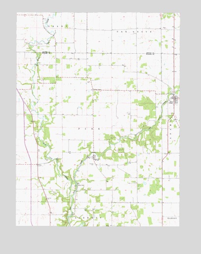
Pine Village, IN USGS Topographic Map
Click on map above to begin viewing in our Map Viewer.

This topographic map contains these locations and features:
Feature Name Type Latitude Longitude GNIS ID View Map
Bartlett CemeteryCemeteryN40.3844°W87.3167°430544View Map
BriscoPopulated PlaceN40.4111°W87.3583°431533View Map
Gray CemeteryCemeteryN40.4414°W87.2878°435365View Map
Hooker CemeteryCemeteryN40.4493°W87.3161°436406View Map
Hooker CornerPopulated PlaceN40.4548°W87.3164°436407View Map
Jones CemeteryCemeteryN40.4597°W87.3212°437086View Map
Keyes CemeteryCemeteryN40.4143°W87.3499°431534View Map
Mud Pine CreekStreamN40.3928°W87.3320°439842View Map
Pine VillagePopulated PlaceN40.4503°W87.2545°441164View Map
Pine Village Volunteer Fire Department and RescueBuildingN40.4488°W87.2547°2626415View Map
RainsvillePopulated PlaceN40.4159°W87.3156°441748View Map
Rainsville CemeteryCemeteryN40.4114°W87.3148°441749View Map
Rocky FordPopulated PlaceN40.3998°W87.3281°442229View Map
Smith CemeteryCemeteryN40.4821°W87.3591°443672View Map
Spring BranchStreamN40.3934°W87.3345°443964View Map
Town of Pine VillageCivilN40.4495°W87.2535°2396857View Map
Township of PineCivilN40.4328°W87.3205°453740View Map
Van Reed CemeteryCemeteryN40.3917°W87.3511°445217View Map

Note: Coordinates in the location and feature list above are referenced to NAD83 datum.


Copyright (C) 2008-2025 Ryan Niemi / Sunset Dynamics ... All Rights Reserved