TopoQuest Logo
Do you find TopoQuest useful?
Help keep TopoQuest running and adding new maps/features by donating!
Bitcoin:  19c7KJd3qBynnjoSw5npx9KScwjBe4ifkT
Litecoin:  LXs6TkuXGGXo1vDsWCkWVdjQX94eUKd6ui
Home View Maps Find Maps Find Places Resources & Links


Grand Rapids, Ohio Topographic Map

USGS Map Title: Grand Rapids, OH
USGS Map MRC: 41083D7
DRG (GeoTIFF) Download: o41083d7.tif


Neighboring USGS Topographic Map Quads:


  Swanton, OH  
41083E8
 

  Whitehouse, OH  
41083E7
 

  Maumee, OH  
41083E6
 

  Colton, OH  
41083D8
 

  Grand Rapids, OH  
41083D7
 

  Bowling Green North, OH  
41083D6
 

  McClure, OH  
41083C8
 

  Weston, OH  
41083C7
 

  Bowling Green South, OH  
41083C6


Map MRC Location:

N42°
W84°
N42°
W83°
H8 H7 H6 H5 H4 H3 H2 H1
G8 G7 G6 G5 G4 G3 G2 G1
F8 F7 F6 F5 F4 F3 F2 F1
E8 E7 E6 E5 E4 E3 E2 E1
D8 D7 D6 D5 D4 D3 D2 D1
C8 C7 C6 C5 C4 C3 C2 C1
B8 B7 B6 B5 B4 B3 B2 B1
A8 A7 A6 A5 A4 A3 A2 A1
N41°
W84°
N41°
W83°

Grand Rapids, OH USGS 1:24K Topographic Map Preview:
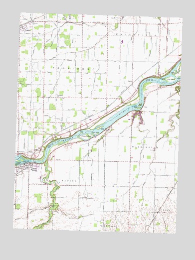
Grand Rapids, OH USGS Topographic Map
Click on map above to begin viewing in our Map Viewer.

This topographic map contains these locations and features:
Feature Name Type Latitude Longitude GNIS ID View Map
Anthony Wayne TrailTrailN41.4292°W83.8430°1048307View Map
Aumend DitchCanalN41.4923°W83.8463°1037544View Map
BaileyPopulated PlaceN41.4620°W83.7877°1068189View Map
Bailey Post Office (historical)Post OfficeN41.4626°W83.7874°2026623View Map
Baumberger DitchCanalN41.4659°W83.8322°1037691View Map
Bear RapidsRapidsN41.4478°W83.7849°1065830View Map
Beaver CreekStreamN41.4145°W83.8527°1066565View Map
Beaver Creek CemeteryCemeteryN41.3884°W83.8463°1037754View Map
Blystone DitchCanalN41.4878°W83.7594°1038158View Map
Butler IslandIslandN41.4687°W83.7549°1038569View Map
Buttonwood IslandIslandN41.4148°W83.8697°1066624View Map
Caseys IslandIslandN41.4312°W83.8152°1038859View Map
Disher DitchCanalN41.4792°W83.7908°1056259View Map
Doran DitchCanalN41.4878°W83.8463°1039751View Map
Estworthy DitchCanalN41.4878°W83.7797°1040237View Map
Fox IslandIslandN41.4314°W83.8255°1040633View Map
Freeworth DitchCanalN41.4201°W83.8663°1040672View Map
Grand RapidsPopulated PlaceN41.4120°W83.8644°1064745View Map
Grand Rapids Branch Weston Public LibraryBuildingN41.4101°W83.8613°1951767View Map
Grand Rapids Elementary SchoolSchoolN41.4112°W83.8633°1050431View Map
Grand Rapids Post OfficePost OfficeN41.4089°W83.8644°1951768View Map
Grand Rapids Township Fire DepartmentBuildingN41.4125°W83.8686°2549359View Map
Grand Rapids Township ParkParkN41.4103°W83.8613°1731426View Map
Harris DitchCanalN41.4784°W83.8294°1041360View Map
Hedges IslandIslandN41.4470°W83.7822°1041458View Map
Herr Airport (historical)AirportN41.4042°W83.7847°1082511View Map
Herr II Airport (historical)AirportN41.4201°W83.7972°1082721View Map
Hertzseld Poultry FarmsLocaleN41.3850°W83.8272°2547150View Map
Howard CemeteryCemeteryN41.4129°W83.8638°1731428View Map
Howard IslandIslandN41.4139°W83.8733°1066757View Map
Indian IslandIslandN41.4637°W83.7583°1041960View Map
Isaac R Ludwig Historical MillLocaleN41.4153°W83.8624°1960704View Map
Jeffers DitchCanalN41.4526°W83.8502°1042060View Map
Kettle RunStreamN41.4359°W83.8038°1042246View Map
Krohn DitchCanalN41.4312°W83.8722°1056386View Map
Laver DitchCanalN41.4812°W83.8627°1042444View Map
Little Beaver CreekStreamN41.3895°W83.8447°1042621View Map
Lock Number 44DamN41.4153°W83.8619°1960705View Map
Lucas County FarmLocaleN41.4987°W83.8022°1051611View Map
Ludwig DitchCanalN41.4387°W83.8216°1048342View Map
Miller DitchCanalN41.4406°W83.8474°1043367View Map
Millers IslandIslandN41.4345°W83.8105°1048344View Map
Mosquito CreekStreamN41.4987°W83.7955°1066357View Map
NeapolisPopulated PlaceN41.4928°W83.8733°1049003View Map
Neapolis Census Designated PlaceCensusN41.4906°W83.8747°2628936View Map
Neapolis Church of ChristChurchN41.4906°W83.8716°1071966View Map
Neapolis Post OfficePost OfficeN41.4931°W83.8736°2026641View Map
Neowash (historical)Populated PlaceN41.4739°W83.7672°1051612View Map
Neowash Post Office (historical)Post OfficeN41.4737°W83.7666°2026636View Map
Number 3 IslandIslandN41.4253°W83.8402°1065835View Map
OtsegoPopulated PlaceN41.4476°W83.7791°1049045View Map
Otsego CemeteryCemeteryN41.4445°W83.7827°1044210View Map
Otter IslandIslandN41.4487°W83.7808°1044216View Map
ProvidencePopulated PlaceN41.4184°W83.8730°1044783View Map
Providence ChurchChurchN41.4520°W83.8444°1048362View Map
Providence Historic DistrictParkN41.4187°W83.8730°1077451View Map
Providence MetroparkParkN41.4162°W83.8686°1043239View Map
Providence Post Office (historical)Post OfficeN41.4181°W83.8736°2027297View Map
Providence Township Fire and Rescue Station 1BuildingN41.4914°W83.8723°2549767View Map
Richman DitchCanalN41.4851°W83.8516°1044982View Map
Riverview Trailer CourtPopulated PlaceN41.4245°W83.8347°1951955View Map
Ruhm DitchCanalN41.4862°W83.8344°1045256View Map
Saint Patrick CemeteryCemeteryN41.4270°W83.8469°1045724View Map
Saint Patricks ChurchChurchN41.4192°W83.8736°1077453View Map
Scherer DitchCanalN41.4676°W83.8138°1048374View Map
Sheets IslandIslandN41.4289°W83.8219°1066953View Map
Sister CreekStreamN41.4456°W83.7835°1046304View Map
Studer DitchCanalN41.4773°W83.8216°1046779View Map
Sugar CreekStreamN41.4459°W83.7819°1046798View Map
Suter DitchCanalN41.4889°W83.7705°1046879View Map
Tondagamies Village (historical)Populated PlaceN41.4662°W83.7666°1083209View Map
Tontogany PrairieAreaN41.4167°W83.7502°1063338View Map
Township of Grand RapidsCivilN41.3969°W83.8467°1087183View Map
Township of ProvidenceCivilN41.4664°W83.8427°1086531View Map
Township of WashingtonCivilN41.4261°W83.7582°1087199View Map
Village of Grand RapidsCivilN41.4078°W83.8679°2398187View Map
Washington CemeteryCemeteryN41.4228°W83.7674°1048386View Map
West Branch Tontogany CreekStreamN41.4439°W83.7513°1047715View Map
Whitemeir DitchCanalN41.4839°W83.7733°1070994View Map
Williams Burg Lake - East DamDamN41.4451°W83.7799°1079518View Map
Williamsburg LakeReservoirN41.4439°W83.7820°1078396View Map
Williamsburg Lake - West DamDamN41.4451°W83.7799°1078395View Map
Williamsburg-On-The-RiverPopulated PlaceN41.4426°W83.7819°1952104View Map
Woodcock IslandIslandN41.4642°W83.7630°1048071View Map
Yawberg DitchCanalN41.4842°W83.8494°1048183View Map

Note: Coordinates in the location and feature list above are referenced to NAD83 datum.


Copyright (C) 2008-2025 Ryan Niemi / Sunset Dynamics ... All Rights Reserved