TopoQuest Logo
Do you find TopoQuest useful?
Help keep TopoQuest running and adding new maps/features by donating!
Bitcoin:  19c7KJd3qBynnjoSw5npx9KScwjBe4ifkT
Litecoin:  LXs6TkuXGGXo1vDsWCkWVdjQX94eUKd6ui
Home View Maps Find Maps Find Places Resources & Links


Swanton, Ohio Topographic Map

USGS Map Title: Swanton, OH
USGS Map MRC: 41083E8
DRG (GeoTIFF) Download: o41083e8.tif


Neighboring USGS Topographic Map Quads:


  Lyons, OH  
41084F1
 

  Assumption, OH  
41083F8
 

  Berkey, OH  
41083F7
 

  Delta, OH  
41084E1
 

  Swanton, OH  
41083E8
 

  Whitehouse, OH  
41083E7
 

  Napoleon East, OH  
41084D1
 

  Colton, OH  
41083D8
 

  Grand Rapids, OH  
41083D7


Map MRC Location:

N42°
W84°
N42°
W83°
H8 H7 H6 H5 H4 H3 H2 H1
G8 G7 G6 G5 G4 G3 G2 G1
F8 F7 F6 F5 F4 F3 F2 F1
E8 E7 E6 E5 E4 E3 E2 E1
D8 D7 D6 D5 D4 D3 D2 D1
C8 C7 C6 C5 C4 C3 C2 C1
B8 B7 B6 B5 B4 B3 B2 B1
A8 A7 A6 A5 A4 A3 A2 A1
N41°
W84°
N41°
W83°

Swanton, OH USGS 1:24K Topographic Map Preview:
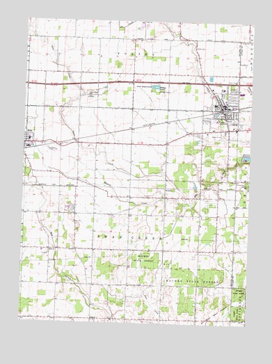
Swanton, OH USGS Topographic Map
Click on map above to begin viewing in our Map Viewer.

This topographic map contains these locations and features:
Feature Name Type Latitude Longitude GNIS ID View Map
Beecher DitchCanalN41.6003°W83.8786°1037800View Map
Blake School (historical)SchoolN41.5553°W83.9794°1080947View Map
BraileyPopulated PlaceN41.5553°W83.9222°1064479View Map
Brailey School (historical)SchoolN41.5523°W83.9405°1080942View Map
Brailey Union ChurchChurchN41.5537°W83.9216°1071866View Map
Brehm's Dairy FarmLocaleN41.5506°W83.9481°2585378View Map
Cately School (historical)SchoolN41.5742°W83.9777°1080944View Map
Center School (historical)SchoolN41.5798°W83.9024°1080939View Map
Centerville CemeteryCemeteryN41.5778°W83.8894°1038947View Map
Crestwood Elementary SchoolSchoolN41.5926°W83.8894°1055282View Map
Delta Industrial ParkLocaleN41.5734°W83.9902°1079672View Map
Delta Wings Airport (historical)AirportN41.5723°W83.9847°1082226View Map
Elton School (historical)SchoolN41.5301°W83.9024°1080940View Map
Fewless CreekStreamN41.5498°W83.9091°1079946View Map
Fulton PondLakeN41.5975°W83.9284°1040724View Map
Fulton Pond Wildlife AreaParkN41.5976°W83.9288°1960499View Map
Fulton Union CemeteryCemeteryN41.5937°W83.9641°1079678View Map
Fulton Union ChurchChurchN41.5942°W83.9655°1040726View Map
Hill DitchCanalN41.5212°W83.8847°1041584View Map
Hoyt School (historical)SchoolN41.5017°W83.9416°1080946View Map
Keen CemeteryCemeteryN41.5417°W83.9713°1042188View Map
King CemeteryCemeteryN41.5592°W83.9999°1042266View Map
Leggett School (historical)SchoolN41.5742°W83.9413°1080945View Map
Linwood Court Mobile Home ParkPopulated PlaceN41.5767°W83.9964°2678151View Map
Lutheran CemeteryCemeteryN41.5237°W83.9419°1079955View Map
Lutz School (historical)SchoolN41.5301°W83.9394°1080943View Map
Maplewood ParkPopulated PlaceN41.5753°W83.9933°2678147View Map
Memorial ParkParkN41.5842°W83.8902°1071885View Map
Park Elementary SchoolSchoolN41.5842°W83.8941°1055294View Map
Peaceful ValleyPopulated PlaceN41.5467°W83.9722°1079685View Map
Raker CemeteryCemeteryN41.5295°W83.9852°1079687View Map
Raker CornersPopulated PlaceN41.5303°W83.9844°1079688View Map
Raker School (historical)SchoolN41.5306°W83.9794°1080948View Map
Raker Union ChurchChurchN41.5301°W83.9849°1079959View Map
Saint Richards Catholic ChurchChurchN41.5987°W83.8913°1071893View Map
Saint Richards CemeteryCemeteryN41.5895°W83.8977°1960512View Map
Saint Richards SchoolSchoolN41.5987°W83.8905°1071894View Map
School Number 12 (historical)SchoolN41.5014°W83.9030°1080941View Map
Shiloh CemeteryCemeteryN41.5009°W83.9605°1079690View Map
Shiloh Christian Union ChurchChurchN41.5014°W83.9605°1072260View Map
South DeltaPopulated PlaceN41.5553°W83.9999°1056945View Map
SwantonPopulated PlaceN41.5887°W83.8911°1061667View Map
Swanton High SchoolSchoolN41.5909°W83.8947°1055298View Map
Swanton Junior High SchoolSchoolN41.5909°W83.8941°1055299View Map
Swanton MeadowsPopulated PlaceN41.6219°W83.9372°2678149View Map
Swanton Missionary Alliance ChurchChurchN41.5876°W83.8883°1071895View Map
Swanton Missionary ChurchChurchN41.5912°W83.8911°1071896View Map
Swanton Police DepartmentBuildingN41.5888°W83.8873°2732856View Map
Swanton Post OfficePost OfficeN41.5889°W83.8916°1987652View Map
Swanton Public LibraryBuildingN41.5889°W83.8863°1077357View Map
Swanton ReservoirReservoirN41.5694°W83.8770°1046898View Map
Swanton Sewage Treatment PlantLocaleN41.5839°W83.8856°2678336View Map
Swissaire EstatesPopulated PlaceN41.5825°W83.8808°2678148View Map
Township of FultonCivilN41.6231°W83.9383°1086125View Map
Township of Swan CreekCivilN41.5380°W83.9409°1086130View Map
Trinity United Methodist ChurchChurchN41.5914°W83.8924°1071903View Map
Village of SwantonCivilN41.5842°W83.8889°2399940View Map
Village of Swanton Fire Department Station 1BuildingN41.5919°W83.8837°2549606View Map
Village of Swanton Fire Department Station 2BuildingN41.5886°W83.8879°2549224View Map
Wagner School (historical)SchoolN41.5012°W83.9805°1080949View Map
WMHE-FM (Delta)TowerN41.5870°W83.9030°1083826View Map

Note: Coordinates in the location and feature list above are referenced to NAD83 datum.


Copyright (C) 2008-2024 Ryan Niemi / Sunset Dynamics ... All Rights Reserved