TopoQuest Logo
Do you find TopoQuest useful?
Help keep TopoQuest running and adding new maps/features by donating!
Bitcoin:  19c7KJd3qBynnjoSw5npx9KScwjBe4ifkT
Litecoin:  LXs6TkuXGGXo1vDsWCkWVdjQX94eUKd6ui
Home View Maps Find Maps Find Places Resources & Links


Grantville, Pennsylvania Topographic Map

USGS Map Title: Grantville, PA
USGS Map MRC: 40076D6
DRG (GeoTIFF) Download: o40076d6.tif


Neighboring USGS Topographic Map Quads:


  Elizabethville, PA  
40076E7
 

  Lykens, PA  
40076E6
 

  Tower City, PA  
40076E5
 

  Enders, PA  
40076D7
 

  Grantville, PA  
40076D6
 

  Indiantown Gap, PA  
40076D5
 

  Harrisburg East, PA  
40076C7
 

  Hershey, PA  
40076C6
 

  Palmyra, PA  
40076C5


Map MRC Location:

N41°
W77°
N41°
W76°
H8 H7 H6 H5 H4 H3 H2 H1
G8 G7 G6 G5 G4 G3 G2 G1
F8 F7 F6 F5 F4 F3 F2 F1
E8 E7 E6 E5 E4 E3 E2 E1
D8 D7 D6 D5 D4 D3 D2 D1
C8 C7 C6 C5 C4 C3 C2 C1
B8 B7 B6 B5 B4 B3 B2 B1
A8 A7 A6 A5 A4 A3 A2 A1
N40°
W77°
N40°
W76°

Grantville, PA USGS 1:24K Topographic Map Preview:
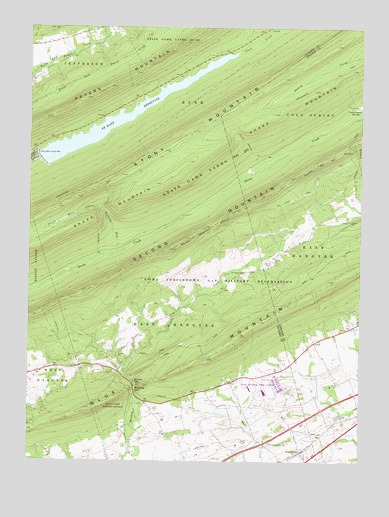
Grantville, PA USGS Topographic Map
Click on map above to begin viewing in our Map Viewer.

This topographic map contains these locations and features:
Feature Name Type Latitude Longitude GNIS ID View Map
Dehart DamDamN40.4584°W76.7464°1194829View Map
Dehart ReservoirReservoirN40.4584°W76.7464°1194828View Map
DeHart ReservoirReservoirN40.4739°W76.7155°1173013View Map
Devils Race CourseStreamN40.4465°W76.7214°1173208View Map
Fort Indiantown GapLocaleN40.4251°W76.6789°1212095View Map
Full MissionChurchN40.4026°W76.7300°1214162View Map
GrantvillePopulated PlaceN40.3779°W76.6464°1175968View Map
Grantville Post OfficePost OfficeN40.3787°W76.6474°2779704View Map
Manada Furnace ChurchChurchN40.3826°W76.6980°1214163View Map
Manada GapPopulated PlaceN40.3973°W76.7100°1204089View Map
Manada GapGapN40.3956°W76.7097°1180253View Map
Manada Golf CourseLocaleN40.3934°W76.6808°1205631View Map
Penn National Race CourseParkN40.3959°W76.6586°1183480View Map
Rattling RunStreamN40.4351°W76.7164°1184687View Map
Saint Pauls CemeteryCemeteryN40.4290°W76.6713°1186561View Map
Second Mountain TrailTrailN40.4548°W76.6527°1193314View Map
State Game Lands Number 211ParkN40.4565°W76.6830°1188488View Map
Stony MountainSummitN40.4695°W76.6877°1193479View Map
Township of East HanoverCivilN40.3910°W76.6845°1216355View Map
Yingst AirportAirportN40.3954°W76.7450°2443660View Map

Note: Coordinates in the location and feature list above are referenced to NAD83 datum.


Copyright (C) 2008-2025 Ryan Niemi / Sunset Dynamics ... All Rights Reserved