TopoQuest Logo
Do you find TopoQuest useful?
Help keep TopoQuest running and adding new maps/features by donating!
Bitcoin:  19c7KJd3qBynnjoSw5npx9KScwjBe4ifkT
Litecoin:  LXs6TkuXGGXo1vDsWCkWVdjQX94eUKd6ui
Home View Maps Find Maps Find Places Resources & Links


Enders, Pennsylvania Topographic Map

USGS Map Title: Enders, PA
USGS Map MRC: 40076D7
DRG (GeoTIFF) Download: o40076d7.tif


Neighboring USGS Topographic Map Quads:


  Millersburg, PA  
40076E8
 

  Elizabethville, PA  
40076E7
 

  Lykens, PA  
40076E6
 

  Halifax, PA  
40076D8
 

  Enders, PA  
40076D7
 

  Grantville, PA  
40076D6
 

  Harrisburg West, PA  
40076C8
 

  Harrisburg East, PA  
40076C7
 

  Hershey, PA  
40076C6


Map MRC Location:

N41°
W77°
N41°
W76°
H8 H7 H6 H5 H4 H3 H2 H1
G8 G7 G6 G5 G4 G3 G2 G1
F8 F7 F6 F5 F4 F3 F2 F1
E8 E7 E6 E5 E4 E3 E2 E1
D8 D7 D6 D5 D4 D3 D2 D1
C8 C7 C6 C5 C4 C3 C2 C1
B8 B7 B6 B5 B4 B3 B2 B1
A8 A7 A6 A5 A4 A3 A2 A1
N40°
W77°
N40°
W76°

Enders, PA USGS 1:24K Topographic Map Preview:
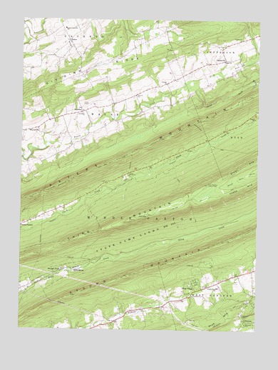
Enders, PA USGS Topographic Map
Click on map above to begin viewing in our Map Viewer.

This topographic map contains these locations and features:
Feature Name Type Latitude Longitude GNIS ID View Map
Bowerman ChurchChurchN40.4626°W76.8425°1170047View Map
Camp ShikellimyLocaleN40.4384°W76.8177°1171091View Map
CarsonvillePopulated PlaceN40.4843°W76.7669°1171279View Map
Carsonville AirportAirportN40.4855°W76.7677°2442789View Map
Carsonville Volunteer Fire Company Dauphin County Station 19BuildingN40.4829°W76.7774°2653354View Map
Dauphin CountyCivilN40.4154°W76.7795°1213667View Map
Devils Race CourseAreaN40.4334°W76.7689°1201484View Map
Dividing RidgeRidgeN40.4737°W76.8564°1173310View Map
Ellendale ForgePopulated PlaceN40.3995°W76.8525°1203511View Map
Ellendale Forge Radio TowerTowerN40.4206°W76.8122°1205680View Map
EndersPopulated PlaceN40.4918°W76.8497°1174253View Map
Enders-Fisherville SchoolSchoolN40.4968°W76.8516°1174254View Map
EnterlinePopulated PlaceN40.4634°W76.8425°1174282View Map
Fairview CemeteryCemeteryN40.4955°W76.8532°2755363View Map
Fishing Creek SchoolSchoolN40.3920°W76.7700°1174845View Map
Gusler AirportAirportN40.4656°W76.8398°1193995View Map
Heckert GapGapN40.3812°W76.7572°1176746View Map
Joseph E. Ibberson Conservation AreaParkN40.4303°W76.8567°2351685View Map
Mount Laurel ParkParkN40.3770°W76.7561°1181735View Map
North Fork Powells CreekStreamN40.4737°W76.7889°1182587View Map
Peters MountainRidgeN40.4454°W76.8214°1183629View Map
PiketownPopulated PlaceN40.3787°W76.7558°1183736View Map
Powells ChurchChurchN40.4745°W76.7977°1184370View Map
Rattling Run TrailTrailN40.4276°W76.7814°1184694View Map
Ritzie VillagePopulated PlaceN40.3945°W76.7819°1185122View Map
Saint James ChurchChurchN40.4923°W76.7594°1186019View Map
Shikellimy TrailTrailN40.4440°W76.8155°1187513View Map
South Fork Powells CreekStreamN40.4734°W76.7886°1188068View Map
Stony Mountain Lookout TowerTowerN40.4337°W76.7758°1188779View Map
Third MountainSummitN40.4204°W76.8100°1193530View Map
Township of WayneCivilN40.4604°W76.8353°1216372View Map
Trinity ChurchChurchN40.4837°W76.7675°1189788View Map
Union Church CemeteryCemeteryN40.4694°W76.8143°1190149View Map
Valley ChurchChurchN40.3784°W76.8241°1190290View Map
Victoria TrailTrailN40.4251°W76.8700°1190399View Map
Water Tank TrailTrailN40.4315°W76.7916°1190667View Map
West Hanover Township Fire Company 1 Station 36 - 3BuildingN40.3864°W76.7543°2100087View Map
White SpringPopulated PlaceN40.3998°W76.8455°1191318View Map

Note: Coordinates in the location and feature list above are referenced to NAD83 datum.


Copyright (C) 2008-2024 Ryan Niemi / Sunset Dynamics ... All Rights Reserved