TopoQuest Logo
Do you find TopoQuest useful?
Help keep TopoQuest running and adding new maps/features by donating!
Bitcoin:  19c7KJd3qBynnjoSw5npx9KScwjBe4ifkT
Litecoin:  LXs6TkuXGGXo1vDsWCkWVdjQX94eUKd6ui
Home View Maps Find Maps Find Places Resources & Links


Elizabethville, Pennsylvania Topographic Map

USGS Map Title: Elizabethville, PA
USGS Map MRC: 40076E7
DRG (GeoTIFF) Download: o40076e7.tif


Neighboring USGS Topographic Map Quads:


  Dalmatia, PA  
40076F8
 

  Pillow, PA  
40076F7
 

  Klingerstown, PA  
40076F6
 

  Millersburg, PA  
40076E8
 

  Elizabethville, PA  
40076E7
 

  Lykens, PA  
40076E6
 

  Halifax, PA  
40076D8
 

  Enders, PA  
40076D7
 

  Grantville, PA  
40076D6


Map MRC Location:

N41°
W77°
N41°
W76°
H8 H7 H6 H5 H4 H3 H2 H1
G8 G7 G6 G5 G4 G3 G2 G1
F8 F7 F6 F5 F4 F3 F2 F1
E8 E7 E6 E5 E4 E3 E2 E1
D8 D7 D6 D5 D4 D3 D2 D1
C8 C7 C6 C5 C4 C3 C2 C1
B8 B7 B6 B5 B4 B3 B2 B1
A8 A7 A6 A5 A4 A3 A2 A1
N40°
W77°
N40°
W76°

Elizabethville, PA USGS 1:24K Topographic Map Preview:
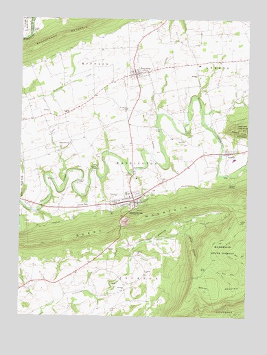
Elizabethville, PA USGS Topographic Map
Click on map above to begin viewing in our Map Viewer.

This topographic map contains these locations and features:
Feature Name Type Latitude Longitude GNIS ID View Map
Berry MountainSummitN40.5351°W76.8269°1200135View Map
BerrysburgPopulated PlaceN40.6020°W76.8119°1169316View Map
Berrysburg and Community Fire Company Station 26BuildingN40.6015°W76.8155°2653060View Map
Berrysburg Post OfficePost OfficeN40.6026°W76.8138°2772595View Map
Borough of BerrysburgCivilN40.6029°W76.8101°1215157View Map
Borough of ElizabethvilleCivilN40.5472°W76.8160°1215159View Map
Boyer SchoolSchoolN40.5687°W76.7739°1197074View Map
Canoe Gap RunStreamN40.5623°W76.7544°1171170View Map
CartinPopulated PlaceN40.5851°W76.8491°1171286View Map
Conleys CreekStreamN40.5084°W76.8452°1202932View Map
Dauphin Meadows LandfillLocaleN40.5539°W76.8700°2725983View Map
Deep HollowValleyN40.5352°W76.7840°1173060View Map
DietrichPopulated PlaceN40.5284°W76.8261°1173266View Map
ElizabethvillePopulated PlaceN40.5490°W76.8119°1174105View Map
Elizabethville Post OfficePost OfficeN40.5514°W76.8118°2772686View Map
Elizabethville QuarryMineN40.5397°W76.8161°2725741View Map
Grimms TrailTrailN40.5218°W76.7564°1205677View Map
Haldeman State ForestForestN40.5334°W76.7664°1192576View Map
Harman AirportAirportN40.5229°W76.8456°2442793View Map
Keiters SchoolSchoolN40.5109°W76.8739°1197071View Map
Koppenhoffer SchoolSchoolN40.5679°W76.8327°1197070View Map
LoyaltonPopulated PlaceN40.5690°W76.7616°1198290View Map
Maple Grove CemeteryCemeteryN40.5515°W76.8194°1180326View Map
MatterstownPopulated PlaceN40.5726°W76.8475°1180558View Map
Miller SchoolSchoolN40.5112°W76.8175°1197072View Map
Minnich Hit TrailTrailN40.5243°W76.7536°1181346View Map
Oakdale ChurchChurchN40.5743°W76.7841°1182811View Map
Oakdale StationLocaleN40.5559°W76.7600°1182814View Map
Pennsylvania State Police Troop H Lykens StationBuildingN40.5586°W76.7942°2754567View Map
Pilgrim ChurchChurchN40.5187°W76.8050°1183738View Map
Reliance Hose Company 1 Station 21BuildingN40.5477°W76.8209°2652955View Map
Riegles ChurchChurchN40.5826°W76.8744°1185057View Map
Rowland Picnic AreaAreaN40.5365°W76.7739°1201559View Map
Saint Jacobs ChurchChurchN40.5109°W76.8166°1186001View Map
Saint Johns ChurchChurchN40.5870°W76.8172°1186119View Map
Saint Pauls ChurchChurchN40.5262°W76.8091°1186601View Map
Saint Peters ChurchChurchN40.6012°W76.7780°1186664View Map
Snyder SchoolSchoolN40.5301°W76.8150°1197073View Map
Straws ChurchChurchN40.5029°W76.8239°1188867View Map
Township of JacksonCivilN40.5252°W76.7753°1216357View Map
Township of MifflinCivilN40.6037°W76.8377°1216364View Map
Township of WashingtonCivilN40.5608°W76.8107°1216371View Map
Upper Dauphin County Emergency Services Station 6BuildingN40.5468°W76.8239°2722121View Map
Wolf PondLakeN40.5202°W76.7722°1191664View Map
Wolf Pond TrailTrailN40.5162°W76.7608°1191665View Map

Note: Coordinates in the location and feature list above are referenced to NAD83 datum.


Copyright (C) 2008-2025 Ryan Niemi / Sunset Dynamics ... All Rights Reserved