TopoQuest Logo
Do you find TopoQuest useful?
Help keep TopoQuest running and adding new maps/features by donating!
Bitcoin:  19c7KJd3qBynnjoSw5npx9KScwjBe4ifkT
Litecoin:  LXs6TkuXGGXo1vDsWCkWVdjQX94eUKd6ui
Home View Maps Find Maps Find Places Resources & Links


Grapeland, Texas Topographic Map

USGS Map Title: Grapeland, TX
USGS Map MRC: 31095D4
DRG (GeoTIFF) Download: o31095d4.tif


Neighboring USGS Topographic Map Quads:


  Elkhart Creek, TX  
31095E5
 

  Percilla, TX  
31095E4
 

  Augusta, TX  
31095E3
 

  Hays Spring, TX  
31095D5
 

  Grapeland, TX  
31095D4
 

  Crockett NE, TX  
31095D3
 

  Porter Springs, TX  
31095C5
 

  Crockett, TX  
31095C4
 

  Berea, TX  
31095C3


Map MRC Location:

N32°
W96°
N32°
W95°
H8 H7 H6 H5 H4 H3 H2 H1
G8 G7 G6 G5 G4 G3 G2 G1
F8 F7 F6 F5 F4 F3 F2 F1
E8 E7 E6 E5 E4 E3 E2 E1
D8 D7 D6 D5 D4 D3 D2 D1
C8 C7 C6 C5 C4 C3 C2 C1
B8 B7 B6 B5 B4 B3 B2 B1
A8 A7 A6 A5 A4 A3 A2 A1
N31°
W96°
N31°
W95°

Grapeland, TX USGS 1:24K Topographic Map Preview:
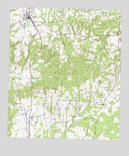
Grapeland, TX USGS Topographic Map
Click on map above to begin viewing in our Map Viewer.

This topographic map contains these locations and features:
Feature Name Type Latitude Longitude GNIS ID View Map
Barfield LakeReservoirN31.4744°W95.4544°1864237View Map
Barfield Lake DamDamN31.4752°W95.4552°1864236View Map
Bennett CreekStreamN31.4966°W95.3961°1351884View Map
Bison DamDamN31.3768°W95.4402°1860719View Map
Bison LakeReservoirN31.3801°W95.4372°1860720View Map
Black Lick BranchStreamN31.3777°W95.4022°1352338View Map
Boiling SpringSpringN31.4918°W95.3919°1998531View Map
Box CemeteryCemeteryN31.3935°W95.4230°1352764View Map
Bruner AirportAirportN31.3935°W95.4743°1387058View Map
City of GrapelandCivilN31.4943°W95.4802°2410649View Map
City of LatexoCivilN31.3955°W95.4680°2411632View Map
Davidson CemeteryCemeteryN31.4591°W95.4449°1384228View Map
Denson CemeteryCemeteryN31.4835°W95.4374°1355921View Map
El CaneyPopulated PlaceN31.4405°W95.4986°1377445View Map
Ephesus ChurchChurchN31.4227°W95.4513°1357046View Map
Grapeand Elementary SchoolSchoolN31.4968°W95.4841°2006290View Map
GrapelandPopulated PlaceN31.4918°W95.4786°1358288View Map
Grapeland City HallBuildingN31.4900°W95.4802°2753697View Map
Grapeland DivisionCivilN31.4928°W95.4228°1938804View Map
Grapeland High SchoolSchoolN31.4927°W95.4813°2006291View Map
Grapeland Police DepartmentBuildingN31.4900°W95.4802°2751302View Map
Grapeland Post OfficePost OfficeN31.4903°W95.4807°2731313View Map
Grapeland Volunteer Fire Department / Emergency Medical ServicesBuildingN31.4903°W95.4807°2655168View Map
Harold Goar DamDamN31.4635°W95.4952°1860721View Map
Harold Goar LakeReservoirN31.4635°W95.4952°1860722View Map
Independent ChurchChurchN31.4082°W95.4866°1359910View Map
LatexoPopulated PlaceN31.3952°W95.4741°1360972View Map
Latexo CemeteryCemeteryN31.4130°W95.4961°1360973View Map
Latexo City HallBuildingN31.3951°W95.4711°2753912View Map
Latexo Community CenterBuildingN31.3952°W95.4722°1377388View Map
Latexo Post OfficePost OfficeN31.3891°W95.4763°2731354View Map
Latexo SchoolSchoolN31.3952°W95.4730°1377378View Map
Latexo SchoolSchoolN31.4049°W95.4852°1360974View Map
Latexo Volunteer Fire DepartmentBuildingN31.3952°W95.4711°2655411View Map
Lone Star Baptist Church (historical)ChurchN31.4566°W95.4058°1377384View Map
M R Murchison DamDamN31.4318°W95.4869°1860717View Map
M R Murchison LakeReservoirN31.4369°W95.4853°1860718View Map
Mayes BranchStreamN31.4318°W95.4877°1362323View Map
McCarthy Chapel CemeteryCemeteryN31.4299°W95.3991°1362376View Map
McCarty ChapelChurchN31.4088°W95.3938°1362378View Map
Milligan CemeteryCemeteryN31.4193°W95.4588°1362924View Map
Murdock CemeteryCemeteryN31.4732°W95.4561°1363495View Map
New Salem CemeteryCemeteryN31.4360°W95.4888°1363773View Map
OldhamPopulated PlaceN31.3988°W95.4836°1377446View Map
Owens CemeteryCemeteryN31.4966°W95.4288°1384233View Map
Philadelphia ChurchChurchN31.4224°W95.3838°1365137View Map
San PedroPopulated PlaceN31.4763°W95.3783°1377447View Map
San Pedro CemeteryCemeteryN31.4774°W95.3797°1377380View Map
San Pedro CemeteryCemeteryN31.4771°W95.3797°1377389View Map
San Pedro ChurchChurchN31.4757°W95.3794°1367536View Map
San Pedro Post Office (historical)Post OfficeN31.4752°W95.3780°1385468View Map
San Pedro School (historical)SchoolN31.4752°W95.4019°1377379View Map
Stowe BranchStreamN31.4721°W95.3938°1377386View Map
Stowe CreekStreamN31.4938°W95.3769°1369258View Map
Stroud BranchStreamN31.4868°W95.4469°1369291View Map
Thomas CreekStreamN31.4902°W95.3891°1377381View Map
Tyer BranchStreamN31.4580°W95.4022°1377385View Map
Tyer CemeteryCemeteryN31.4571°W95.4052°1370412View Map
Tyer Water Wheel (historical)BuildingN31.4585°W95.4077°1377387View Map
Union ChapelChurchN31.4757°W95.4363°1370441View Map
Wall CemeteryCemeteryN31.3941°W95.4147°1370778View Map
Whitaker CreekStreamN31.4935°W95.3772°1377382View Map

Note: Coordinates in the location and feature list above are referenced to NAD83 datum.


Copyright (C) 2008-2025 Ryan Niemi / Sunset Dynamics ... All Rights Reserved