TopoQuest Logo
Do you find TopoQuest useful?
Help keep TopoQuest running and adding new maps/features by donating!
Bitcoin:  19c7KJd3qBynnjoSw5npx9KScwjBe4ifkT
Litecoin:  LXs6TkuXGGXo1vDsWCkWVdjQX94eUKd6ui
Home View Maps Find Maps Find Places Resources & Links


Crockett NE, Texas Topographic Map

USGS Map Title: Crockett NE, TX
USGS Map MRC: 31095D3
DRG (GeoTIFF) Download: o31095d3.tif


Neighboring USGS Topographic Map Quads:


  Percilla, TX  
31095E4
 

  Augusta, TX  
31095E3
 

  Weches, TX  
31095E2
 

  Grapeland, TX  
31095D4
 

  Crockett NE, TX  
31095D3
 

  Ratcliff, TX  
31095D2
 

  Crockett, TX  
31095C4
 

  Berea, TX  
31095C3
 

  Kennard, TX  
31095C2


Map MRC Location:

N32°
W96°
N32°
W95°
H8 H7 H6 H5 H4 H3 H2 H1
G8 G7 G6 G5 G4 G3 G2 G1
F8 F7 F6 F5 F4 F3 F2 F1
E8 E7 E6 E5 E4 E3 E2 E1
D8 D7 D6 D5 D4 D3 D2 D1
C8 C7 C6 C5 C4 C3 C2 C1
B8 B7 B6 B5 B4 B3 B2 B1
A8 A7 A6 A5 A4 A3 A2 A1
N31°
W96°
N31°
W95°

Crockett NE, TX USGS 1:24K Topographic Map Preview:
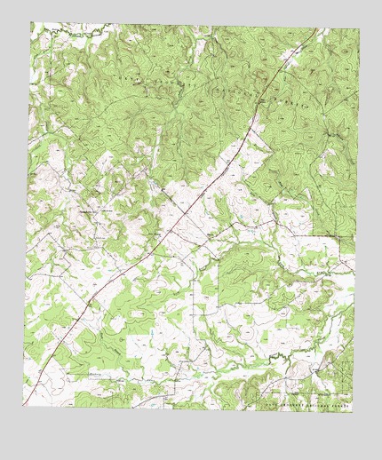
Crockett NE, TX USGS Topographic Map
Click on map above to begin viewing in our Map Viewer.

This topographic map contains these locations and features:
Feature Name Type Latitude Longitude GNIS ID View Map
BelottPopulated PlaceN31.4307°W95.3061°1383026View Map
Belott Masonic LodgeBuildingN31.4296°W95.3108°1383269View Map
Belott Post Office (historical)Post OfficeN31.4310°W95.3144°1385463View Map
Belott School (historical)SchoolN31.4316°W95.3055°1383277View Map
Belott Volunteer Fire DepartmentBuildingN31.4308°W95.3151°2655409View Map
Belott Woodmen of the World LodgeBuildingN31.4291°W95.3099°1383268View Map
Black BranchStreamN31.3843°W95.3338°1383034View Map
Broxson LakeReservoirN31.4335°W95.3386°1864269View Map
Broxson Lake DamDamN31.4335°W95.3386°1864268View Map
Caney CreekStreamN31.3977°W95.2638°1383273View Map
Cook BranchStreamN31.4960°W95.3672°1383070View Map
Dibrell Airport (historical)AirportN31.4433°W95.2745°1386452View Map
Edens-Madden Massacre CemeteryCemeteryN31.4868°W95.3622°1383272View Map
Edens-Madden Massacre SiteLocaleN31.4868°W95.3622°1383271View Map
Fennell Memory GardenCemeteryN31.4568°W95.2624°1377342View Map
Fennell/Robertson Genealogy Society LibraryBuildingN31.4560°W95.2627°1383266View Map
Ferrell Branch SpringSpringN31.4596°W95.2836°1383264View Map
GermanyPopulated PlaceN31.4399°W95.3508°1383341View Map
Gilbreath Memorial LibraryBuildingN31.4907°W95.2858°2014962View Map
Glover SchoolSchoolN31.4393°W95.3466°1383096View Map
Grounds CemeteryCemeteryN31.4305°W95.3491°1383097View Map
Hayman CreekStreamN31.3921°W95.2747°1383274View Map
Hickory CreekPopulated PlaceN31.3788°W95.3213°1383342View Map
Kelly BranchStreamN31.4207°W95.2691°1383117View Map
Last Resort AirportAirportN31.4522°W95.2954°1386451View Map
Lockey Gin (historical)BuildingN31.4291°W95.3094°1383270View Map
New Energy ChurchChurchN31.4305°W95.3252°1383139View Map
Old Enterprise School (historical)SchoolN31.4377°W95.2813°1383276View Map
Parker CemeteryCemeteryN31.4335°W95.3647°1383146View Map
Pine SpringSpringN31.4752°W95.2879°1383156View Map
Pine Springs Campground (historical)LocaleN31.4752°W95.2880°1383265View Map
Pleasant Hill ChurchChurchN31.4382°W95.3486°1383158View Map
Strode-Pritchet Cabin (historical)BuildingN31.4399°W95.3138°1383267View Map
Viola School (historical)SchoolN31.4657°W95.2888°1383275View Map

Note: Coordinates in the location and feature list above are referenced to NAD83 datum.


Copyright (C) 2008-2025 Ryan Niemi / Sunset Dynamics ... All Rights Reserved