TopoQuest Logo
Do you find TopoQuest useful?
Help keep TopoQuest running and adding new maps/features by donating!
Bitcoin:  19c7KJd3qBynnjoSw5npx9KScwjBe4ifkT
Litecoin:  LXs6TkuXGGXo1vDsWCkWVdjQX94eUKd6ui
Home View Maps Find Maps Find Places Resources & Links


Westport, Washington Topographic Map

USGS Map Title: Westport, WA
USGS Map MRC: 46124H1
DRG (GeoTIFF) Download: o46124h1.tif


Neighboring USGS Topographic Map Quads:


  Copalis Beach, WA  
47124A2
 

  Copalis Crossing, WA  
47124A1
 

  New London, WA  
47123A8
 

  Point Brown, WA  
46124H2
 

  Westport, WA  
46124H1
 

  Hoquiam, WA  
46123H8


  Grayland, WA  
46124G1
 

  Western, WA  
46123G8


Map MRC Location:

N47°
W125°
N47°
W124°
H8 H7 H6 H5 H4 H3 H2 H1
G8 G7 G6 G5 G4 G3 G2 G1
F8 F7 F6 F5 F4 F3 F2 F1
E8 E7 E6 E5 E4 E3 E2 E1
D8 D7 D6 D5 D4 D3 D2 D1
C8 C7 C6 C5 C4 C3 C2 C1
B8 B7 B6 B5 B4 B3 B2 B1
A8 A7 A6 A5 A4 A3 A2 A1
N46°
W125°
N46°
W124°

Westport, WA USGS 1:24K Topographic Map Preview:
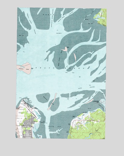
Westport, WA USGS Topographic Map
Click on map above to begin viewing in our Map Viewer.

This topographic map contains these locations and features:
Feature Name Type Latitude Longitude GNIS ID View Map
Armstrong BayBayN46.9470°W124.1235°1534115View Map
Bowerman BasinBayN46.8947°W124.0553°1533527View Map
Brackenridge BluffCliffN46.9831°W124.0029°1503526View Map
City of WestportCivilN46.8923°W124.1132°2412243View Map
City of Westport Fire DepartmentBuildingN46.8892°W124.1051°2619499View Map
Coast Guard Station Grays HarborMilitaryN46.9039°W124.1046°2512109View Map
Damon PointCapeN46.9424°W124.1107°1510695View Map
Goose IslandIslandN46.9773°W124.0702°1505192View Map
Grass Creek ChannelChannelN46.9937°W124.0252°1505235View Map
Grass IslandIslandN46.8762°W124.0907°1505236View Map
Grays HarborBayN46.9562°W124.0417°1505249View Map
Grays Harbor CGLocaleN46.9031°W124.1055°1511736View Map
Grays Harbor LighthouseBuildingN46.8882°W124.1170°2610228View Map
Hoquiam Radio Range StationTowerN46.8998°W124.1224°1533137View Map
Humptulips River ChannelChannelN46.9881°W124.0743°1505665View Map
Johns RiverStreamN46.9073°W124.0113°1505835View Map
Kingdom Hall of Jehovahs WitnessesChurchN46.8872°W124.1060°2609906View Map
Lone TreeCapeN46.9465°W124.1166°1514711View Map
Neds RockIslandN46.9893°W124.0263°1506938View Map
North BayBayN46.9997°W124.0855°1507015View Map
OcostaPopulated PlaceN46.8887°W124.0385°1507142View Map
Oyhut ChannelChannelN46.9979°W124.1130°1507241View Map
Point NewCapeN46.9912°W124.0177°1507529View Map
Redman SloughStreamN46.8998°W124.0263°1507759View Map
Saint Christopher Episcopal ChurchChurchN46.8892°W124.1063°2608536View Map
Sand IslandIslandN46.9618°W124.0582°1508092View Map
Sand Island ShoalBarN46.9534°W124.0652°1508093View Map
South BayBayN46.8837°W124.0732°1508503View Map
South Beach Ambulance ServiceBuildingN46.8892°W124.1053°2643265View Map
Twin Harbor Baptist ChurchChurchN46.8818°W124.1124°2609191View Map
WesthavenPopulated PlaceN46.9084°W124.1132°1512798View Map
Westhaven CoveBayN46.9081°W124.1087°1509934View Map
WestportPopulated PlaceN46.8901°W124.1041°1531536View Map
Westport AirportAirportN46.8978°W124.1036°1534032View Map
Westport City HallBuildingN46.8932°W124.1040°2610576View Map
Westport Light State ParkParkN46.8929°W124.1235°1531798View Map
Westport MarinaLocaleN46.9079°W124.1089°2610274View Map
Westport Maritime MuseumBuildingN46.9077°W124.1119°2610484View Map
Westport Police DepartmentBuildingN46.8932°W124.1040°2721993View Map
Westport Post OfficePost OfficeN46.8873°W124.1089°2607041View Map
Westport Timberland LibraryBuildingN46.8856°W124.1038°2610215View Map
Westport Wastewater Treatment PlantLocaleN46.9062°W124.1154°2610742View Map
Whitcomb FlatsBarN46.9109°W124.0816°1509459View Map

Note: Coordinates in the location and feature list above are referenced to NAD83 datum.


Copyright (C) 2008-2024 Ryan Niemi / Sunset Dynamics ... All Rights Reserved