TopoQuest Logo
Do you find TopoQuest useful?
Help keep TopoQuest running and adding new maps/features by donating!
Bitcoin:  19c7KJd3qBynnjoSw5npx9KScwjBe4ifkT
Litecoin:  LXs6TkuXGGXo1vDsWCkWVdjQX94eUKd6ui
Home View Maps Find Maps Find Places Resources & Links


Grays Chapel, North Carolina Topographic Map

USGS Map Title: Grays Chapel, NC
USGS Map MRC: 35079G6
DRG (GeoTIFF) Download: o35079g6.tif


Neighboring USGS Topographic Map Quads:


  Pleasant Garden, NC  
35079H7
 

  Climax, NC  
35079H6
 

  Kimesville, NC  
35079H5
 

  Randleman, NC  
35079G7
 

  Grays Chapel, NC  
35079G6
 

  Liberty, NC  
35079G5
 

  Asheboro, NC  
35079F7
 

  Ramseur, NC  
35079F6
 

  Coleridge, NC  
35079F5


Map MRC Location:

N36°
W80°
N36°
W79°
H8 H7 H6 H5 H4 H3 H2 H1
G8 G7 G6 G5 G4 G3 G2 G1
F8 F7 F6 F5 F4 F3 F2 F1
E8 E7 E6 E5 E4 E3 E2 E1
D8 D7 D6 D5 D4 D3 D2 D1
C8 C7 C6 C5 C4 C3 C2 C1
B8 B7 B6 B5 B4 B3 B2 B1
A8 A7 A6 A5 A4 A3 A2 A1
N35°
W80°
N35°
W79°

Grays Chapel, NC USGS 1:24K Topographic Map Preview:
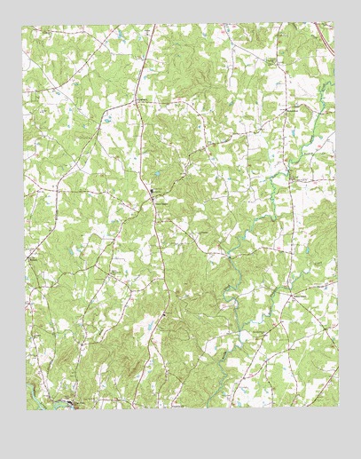
Grays Chapel, NC USGS Topographic Map
Click on map above to begin viewing in our Map Viewer.

This topographic map contains these locations and features:
Feature Name Type Latitude Longitude GNIS ID View Map
B J Poultry FarmLocaleN35.8594°W79.6506°2647238View Map
Boodom CreekStreamN35.8318°W79.6381°981725View Map
Cedar FallsPopulated PlaceN35.7521°W79.7314°1019575View Map
Clear View ChurchChurchN35.7537°W79.7228°983259View Map
Climax Fire Department Station 42BuildingN35.8443°W79.7178°2638380View Map
Cool Springs ChurchChurchN35.8071°W79.6803°983490View Map
Faith Temple ChurchChurchN35.8015°W79.7473°984968View Map
Franklinville Fire Department Station 22BuildingN35.7982°W79.6428°2638204View Map
Gabriels CreekStreamN35.7512°W79.7445°1011417View Map
Grace ChurchChurchN35.8362°W79.6736°985894View Map
Grays ChapelPopulated PlaceN35.8187°W79.6986°985996View Map
Grays Chapel Elementary SchoolSchoolN35.8210°W79.6984°1006764View Map
LinberryPopulated PlaceN35.8504°W79.7045°988491View Map
Lineberry LakeReservoirN35.8265°W79.6960°999532View Map
Lineberry Lake DamDamN35.8268°W79.6947°999533View Map
MelanchtonPopulated PlaceN35.8468°W79.6442°989711View Map
MillboroPopulated PlaceN35.7999°W79.7481°989990View Map
Mount Pleasant CreekStreamN35.7757°W79.6642°990559View Map
Patterson Grove ChurchChurchN35.7746°W79.6547°991940View Map
Providence ChurchChurchN35.8729°W79.7381°992880View Map
Randolph ChurchChurchN35.8618°W79.6486°993026View Map
Redcross ChurchChurchN35.8718°W79.6989°993139View Map
Rising Meadow FarmLocaleN35.8353°W79.6556°2647179View Map
Sandy Creek ChurchChurchN35.8237°W79.6411°994262View Map
Sandy Creek MissionChurchN35.8237°W79.6420°994264View Map
Township of FranklinvilleCivilN35.7608°W79.7296°1027081View Map
Township of ProvidenceCivilN35.8569°W79.7206°1027088View Map
Whites ChapelLocaleN35.7865°W79.6434°997248View Map
Whites Memorial ChurchChurchN35.7946°W79.7153°997255View Map
Yorks FieldAirportN35.7547°W79.6682°997965View Map

Note: Coordinates in the location and feature list above are referenced to NAD83 datum.


Copyright (C) 2008-2024 Ryan Niemi / Sunset Dynamics ... All Rights Reserved