TopoQuest Logo
Do you find TopoQuest useful?
Help keep TopoQuest running and adding new maps/features by donating!
Bitcoin:  19c7KJd3qBynnjoSw5npx9KScwjBe4ifkT
Litecoin:  LXs6TkuXGGXo1vDsWCkWVdjQX94eUKd6ui
Home View Maps Find Maps Find Places Resources & Links


Pineville, South Carolina Topographic Map

USGS Map Title: Pineville, SC
USGS Map MRC: 33080D1
DRG (GeoTIFF) Download: o33080d1.tif


Neighboring USGS Topographic Map Quads:


  Jordan, SC  
33080E2
 

  Butlers Bay, SC  
33080E1
 

  Greeleyville, SC  
33079E8
 

  Eadytown, SC  
33080D2
 

  Pineville, SC  
33080D1
 

  Saint Stephen, SC  
33079D8
 

  Cross, SC  
33080C2
 

  Chicora, SC  
33080C1
 

  Bonneau, SC  
33079C8


Map MRC Location:

N34°
W81°
N34°
W80°
H8 H7 H6 H5 H4 H3 H2 H1
G8 G7 G6 G5 G4 G3 G2 G1
F8 F7 F6 F5 F4 F3 F2 F1
E8 E7 E6 E5 E4 E3 E2 E1
D8 D7 D6 D5 D4 D3 D2 D1
C8 C7 C6 C5 C4 C3 C2 C1
B8 B7 B6 B5 B4 B3 B2 B1
A8 A7 A6 A5 A4 A3 A2 A1
N33°
W81°
N33°
W80°

Pineville, SC USGS 1:24K Topographic Map Preview:
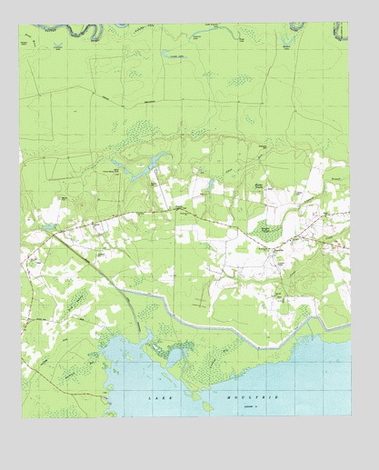
Pineville, SC USGS Topographic Map
Click on map above to begin viewing in our Map Viewer.

This topographic map contains these locations and features:
Feature Name Type Latitude Longitude GNIS ID View Map
Belle Isle ChapelChurchN33.4254°W80.1217°1220482View Map
Belle Isle PlantationLocaleN33.4543°W80.0867°1234269View Map
Belle Isle Plantation CemeteryCemeteryN33.4540°W80.0873°1234270View Map
Bellisle School (historical)SchoolN33.4377°W80.0926°1234271View Map
Bluford CemeteryCemeteryN33.4488°W80.0756°1220835View Map
Buckhall Bay (historical)SwampN33.3807°W80.0054°1234281View Map
Bulltown BaySwampN33.3903°W80.1032°1247064View Map
Bulltown DitchCanalN33.3985°W80.1101°1221121View Map
Cahusac LakeSwampN33.4989°W80.0770°1247082View Map
Cordes LakeLakeN33.4893°W80.0657°1221756View Map
Couturier LakeLakeN33.4934°W80.1098°1221779View Map
Crooked BaySwampN33.3923°W80.0530°1221831View Map
Cross School (historical)SchoolN33.4299°W80.0079°1234292View Map
Day Dawn ChurchChurchN33.4307°W80.0226°1247502View Map
Dead RiverStreamN33.4968°W80.1248°1221957View Map
Glen Camp PlantationLocaleN33.4196°W80.0692°1234309View Map
Green Hill School (historical)SchoolN33.3910°W80.0781°1234311View Map
Jefferson CemeteryCemeteryN33.4274°W80.0959°1223523View Map
Jehovah ChurchChurchN33.4132°W80.0290°1223530View Map
Johns RunStreamN33.4610°W80.0287°1223598View Map
Judge TownPopulated PlaceN33.4321°W80.0192°1234326View Map
Kirk SwampSwampN33.4122°W80.1037°1223746View Map
Lifeland CemeteryCemeteryN33.4460°W80.0206°1223905View Map
Maham LakeLakeN33.4933°W80.0226°1224275View Map
Maham SwampSwampN33.4480°W80.0347°1224276View Map
Mahan Plantation CemeteryCemeteryN33.4457°W80.0545°1234336View Map
Margate SwampSwampN33.4337°W80.0313°1224309View Map
Maude Cullen Health CenterHospitalN33.4396°W80.0609°1247935View Map
Messiah ChurchChurchN33.4363°W80.0976°1224460View Map
Mexico CemeteryCemeteryN33.4452°W80.1101°1224463View Map
Mount Nebo ChurchChurchN33.4399°W80.0806°1249609View Map
Murrell (historical)Populated PlaceN33.4263°W80.0304°1234350View Map
Oakland ClubLocaleN33.4529°W80.0731°1234355View Map
Palmer Chapel (historical)ChurchN33.3896°W80.0629°1234360View Map
Pilgrim ChurchChurchN33.4382°W80.0087°1250087View Map
PinevillePopulated PlaceN33.4282°W80.0292°1225481View Map
Pineville Lookout TowerTowerN33.4413°W80.0665°1242459View Map
Pineville Post OfficePost OfficeN33.4307°W80.0247°2489873View Map
Prince Hill School (historical)SchoolN33.4132°W80.0290°1234365View Map
Redeemer ChurchChurchN33.4399°W80.0612°1225795View Map
Redeemer ChurchChurchN33.4282°W80.0315°1250317View Map
Redeemer School (historical)SchoolN33.4396°W80.0609°1234368View Map
Region Town (historical)Populated PlaceN33.4454°W80.0298°1234369View Map
Richmond CemeteryCemeteryN33.4607°W80.0309°1225871View Map
Saint Johns Church (historical)ChurchN33.4171°W80.0276°1706240View Map
Saint Peters ChurchChurchN33.4124°W80.0254°1250688View Map
Saint Stephen DivisionCivilN33.4146°W80.0052°1938408View Map
Santee CanalCanalN33.4266°W80.1020°1250781View Map
Sinkler Dam (historical)DamN33.4813°W80.1240°1234390View Map
Site of Francis Marion TombCemeteryN33.4529°W80.0876°1226652View Map
Smiths ChapelChurchN33.4357°W80.1012°1234391View Map
Solomon LakeLakeN33.4983°W80.0503°1226746View Map
South Carolina Noname 14004 D-3508 DamDamN33.4435°W80.1031°1238624View Map
Tower Hill PlantationLocaleN33.4529°W80.0570°1234403View Map
Wing RoadPopulated PlaceN33.4210°W80.0665°1234411View Map
Wood LakeLakeN33.4950°W80.0420°1227693View Map

Note: Coordinates in the location and feature list above are referenced to NAD83 datum.


Copyright (C) 2008-2024 Ryan Niemi / Sunset Dynamics ... All Rights Reserved