TopoQuest Logo
Do you find TopoQuest useful?
Help keep TopoQuest running and adding new maps/features by donating!
Bitcoin:  19c7KJd3qBynnjoSw5npx9KScwjBe4ifkT
Litecoin:  LXs6TkuXGGXo1vDsWCkWVdjQX94eUKd6ui
Home View Maps Find Maps Find Places Resources & Links


Butlers Bay, South Carolina Topographic Map

USGS Map Title: Butlers Bay, SC
USGS Map MRC: 33080E1
DRG (GeoTIFF) Download: o33080e1.tif


Neighboring USGS Topographic Map Quads:


  Manning, SC  
33080F2
 

  Foreston, SC  
33080F1
 

  Workman, SC  
33079F8
 

  Jordan, SC  
33080E2
 

  Butlers Bay, SC  
33080E1
 

  Greeleyville, SC  
33079E8
 

  Eadytown, SC  
33080D2
 

  Pineville, SC  
33080D1
 

  Saint Stephen, SC  
33079D8


Map MRC Location:

N34°
W81°
N34°
W80°
H8 H7 H6 H5 H4 H3 H2 H1
G8 G7 G6 G5 G4 G3 G2 G1
F8 F7 F6 F5 F4 F3 F2 F1
E8 E7 E6 E5 E4 E3 E2 E1
D8 D7 D6 D5 D4 D3 D2 D1
C8 C7 C6 C5 C4 C3 C2 C1
B8 B7 B6 B5 B4 B3 B2 B1
A8 A7 A6 A5 A4 A3 A2 A1
N33°
W81°
N33°
W80°

Butlers Bay, SC USGS 1:24K Topographic Map Preview:
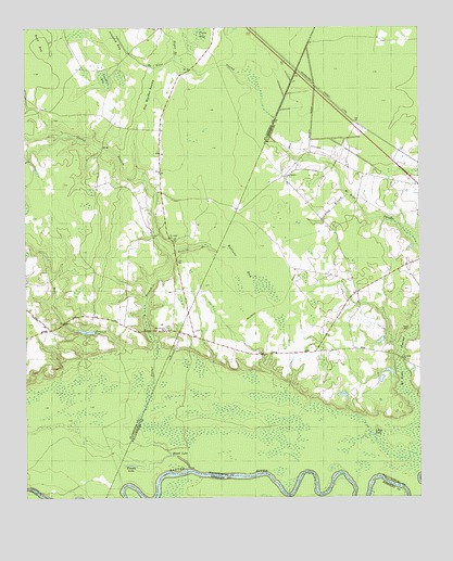
Butlers Bay, SC USGS Topographic Map
Click on map above to begin viewing in our Map Viewer.

This topographic map contains these locations and features:
Feature Name Type Latitude Longitude GNIS ID View Map
Broad LakeLakeN33.5129°W80.0790°1220974View Map
Buck BaySwampN33.6213°W80.1201°1221062View Map
Butlers BaySwampN33.5627°W80.0562°1221168View Map
Doctor BranchStreamN33.5077°W80.0729°1222045View Map
Doctor HoleSwampN33.5179°W80.0220°1241406View Map
Doctor HoleLakeN33.5179°W80.0242°1222046View Map
Franks LakeLakeN33.5089°W80.0917°1229718View Map
Green Hill ChurchChurchN33.5979°W80.0976°1235937View Map
Highland CreekStreamN33.5113°W80.0784°1223174View Map
Hog Meadow SwampSwampN33.6066°W80.0852°1223215View Map
Hunter School (historical)SchoolN33.5388°W80.0379°1241431View Map
Hunter School (historical)SchoolN33.5382°W80.0526°1241432View Map
Islanded BaySwampN33.6227°W80.0954°1223469View Map
Keels CemeteryCemeteryN33.5452°W80.0051°1223698View Map
Little LakeLakeN33.5168°W80.0149°1224008View Map
Little Solomon LakeSwampN33.5005°W80.0492°1224055View Map
Long BranchStreamN33.5807°W80.0226°1224116View Map
Long Branch ChurchChurchN33.5857°W80.0423°1224160View Map
Mill BranchStreamN33.5391°W80.0931°1224520View Map
Mount Hope SwampStreamN33.5227°W80.0006°1249590View Map
Oak Grove Church (historical)ChurchN33.5716°W80.0267°1241482View Map
Pine Grove ChurchChurchN33.5454°W80.0809°1250099View Map
Riggs PondReservoirN33.5485°W80.1248°1240023View Map
Riggs Pond Dam D-3507DamN33.5485°W80.1248°1240022View Map
Saint Johns School (historical)SchoolN33.5352°W80.0026°1241504View Map
Saint Lukes ChurchChurchN33.5691°W80.0790°1236015View Map
Sandhill BaySwampN33.6114°W80.0994°1226347View Map
Santee Rosenwald School (historical)SchoolN33.5591°W80.0984°1236030View Map
Tarkiln BranchStreamN33.5646°W80.0787°1236050View Map
Tiger BaySwampN33.6243°W80.0688°1227131View Map
Torkiln BranchStreamN33.5646°W80.0787°1227178View Map

Note: Coordinates in the location and feature list above are referenced to NAD83 datum.


Copyright (C) 2008-2024 Ryan Niemi / Sunset Dynamics ... All Rights Reserved