TopoQuest Logo
Do you find TopoQuest useful?
Help keep TopoQuest running and adding new maps/features by donating!
Bitcoin:  19c7KJd3qBynnjoSw5npx9KScwjBe4ifkT
Litecoin:  LXs6TkuXGGXo1vDsWCkWVdjQX94eUKd6ui
Home View Maps Find Maps Find Places Resources & Links


Pushaw Lake, Maine Topographic Map

USGS Map Title: Pushaw Lake, ME
USGS Map MRC: 44068H7
DRG (GeoTIFF) Download: o44068h7.tif


Neighboring USGS Topographic Map Quads:


  Bradford, ME  
45068A8
 

  South Lagrange, ME  
45068A7
 

  Greenbush, ME  
45068A6
 

  Kenduskeag, ME  
44068H8
 

  Pushaw Lake, ME  
44068H7
 

  Old Town, ME  
44068H6
 

  Hermon, ME  
44068G8
 

  Bangor, ME  
44068G7
 

  Veazie, ME  
44068G6


Map MRC Location:

N45°
W69°
N45°
W68°
H8 H7 H6 H5 H4 H3 H2 H1
G8 G7 G6 G5 G4 G3 G2 G1
F8 F7 F6 F5 F4 F3 F2 F1
E8 E7 E6 E5 E4 E3 E2 E1
D8 D7 D6 D5 D4 D3 D2 D1
C8 C7 C6 C5 C4 C3 C2 C1
B8 B7 B6 B5 B4 B3 B2 B1
A8 A7 A6 A5 A4 A3 A2 A1
N44°
W69°
N44°
W68°

Pushaw Lake, ME USGS 1:24K Topographic Map Preview:
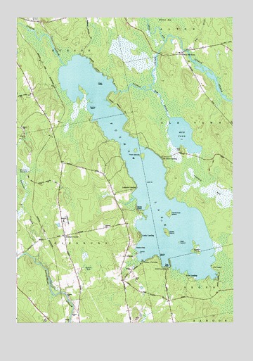
Pushaw Lake, ME USGS Topographic Map
Click on map above to begin viewing in our Map Viewer.

This topographic map contains these locations and features:
Feature Name Type Latitude Longitude GNIS ID View Map
Camp TelokLocaleN44.9462°W68.7806°563418View Map
Caribou BogSwampN44.9265°W68.7542°563517View Map
Cunningham Landing (historical)LocaleN44.9012°W68.8048°1913440View Map
Dead StreamStreamN44.9903°W68.7898°564891View Map
Dollar IslandIslandN44.9120°W68.7884°565185View Map
Double A LandingPopulated PlaceN44.9003°W68.8025°579250View Map
Double A Seaplane BaseAirportN44.9009°W68.8017°582152View Map
Dufour Landing (historical)LocaleN44.9040°W68.7870°1913466View Map
Elliot LandingPopulated PlaceN44.8937°W68.7723°579289View Map
French PointCapeN44.9037°W68.8045°566573View Map
Glenburn and Hudson Ambulance ServiceBuildingN44.9134°W68.8246°2666748View Map
Glenburn CenterPopulated PlaceN44.9106°W68.8473°566839View Map
Glenburn Elementary SchoolSchoolN44.9167°W68.8476°566840View Map
Glenburn Evangelical ChurchChurchN44.9092°W68.8467°1913547View Map
Glenburn Fire Department Station 22BuildingN44.9134°W68.8246°2552712View Map
Glenburn LibraryBuildingN44.9160°W68.8473°1913548View Map
Gould LandingPopulated PlaceN44.8973°W68.7881°566995View Map
Hardwood IslandIslandN44.9198°W68.7873°567620View Map
Hollis BogSwampN44.8965°W68.8336°568193View Map
Lakeside LandingPopulated PlaceN44.9303°W68.8061°579466View Map
Lakeview CemeteryCemeteryN44.9145°W68.8248°569330View Map
Lancaster BrookStreamN44.8967°W68.8567°569356View Map
Lucky LandingPopulated PlaceN44.9106°W68.8034°570575View Map
Lucky Landing Marina and Seaplane BaseAirportN44.9070°W68.8045°582111View Map
Mags LedgeBarN44.9728°W68.8289°570653View Map
Marston MeadowSwampN44.9362°W68.8714°570835View Map
Moose IslandIslandN44.9056°W68.7711°571598View Map
Mouse IslandIslandN44.9028°W68.7925°571830View Map
Mud StreamStreamN44.9706°W68.7986°571957View Map
Old Town LandingPopulated PlaceN44.9426°W68.7920°579588View Map
Perch PondLakeN44.9518°W68.7792°571907View Map
Pug BrookStreamN44.9851°W68.7756°573862View Map
Pushaw LakeReservoirN44.9330°W68.8010°573904View Map
Pushaw Lake DamDamN44.9699°W68.8148°1774549View Map
Ram IslandIslandN44.9076°W68.7811°574006View Map
Sandy BeachPopulated PlaceN44.9215°W68.8064°574868View Map
Squirrel IslandIslandN44.9637°W68.8320°576207View Map
Town of GlenburnCivilN44.9076°W68.8488°582491View Map
Twin IslandsIslandN44.9440°W68.8036°577479View Map
Villa VaughnPopulated PlaceN44.8973°W68.7620°579790View Map
West Old TownPopulated PlaceN44.9848°W68.7800°578181View Map

Note: Coordinates in the location and feature list above are referenced to NAD83 datum.


Copyright (C) 2008-2024 Ryan Niemi / Sunset Dynamics ... All Rights Reserved