TopoQuest Logo
Do you find TopoQuest useful?
Help keep TopoQuest running and adding new maps/features by donating!
Bitcoin:  19c7KJd3qBynnjoSw5npx9KScwjBe4ifkT
Litecoin:  LXs6TkuXGGXo1vDsWCkWVdjQX94eUKd6ui
Home View Maps Find Maps Find Places Resources & Links


Greenvine, Texas Topographic Map

USGS Map Title: Greenvine, TX
USGS Map MRC: 30096A5
DRG (GeoTIFF) Download: o30096a5.tif


Neighboring USGS Topographic Map Quads:


  Carmine, TX  
30096B6
 

  Burton, TX  
30096B5
 

  Brenham, TX  
30096B4
 

  Round Top, TX  
30096A6
 

  Greenvine, TX  
30096A5
 

  Welcome, TX  
30096A4
 

  Fayetteville, TX  
29096H6
 

  Industry, TX  
29096H5
 

  New Ulm, TX  
29096H4


Map MRC Location:

N31°
W97°
N31°
W96°
H8 H7 H6 H5 H4 H3 H2 H1
G8 G7 G6 G5 G4 G3 G2 G1
F8 F7 F6 F5 F4 F3 F2 F1
E8 E7 E6 E5 E4 E3 E2 E1
D8 D7 D6 D5 D4 D3 D2 D1
C8 C7 C6 C5 C4 C3 C2 C1
B8 B7 B6 B5 B4 B3 B2 B1
A8 A7 A6 A5 A4 A3 A2 A1
N30°
W97°
N30°
W96°

Greenvine, TX USGS 1:24K Topographic Map Preview:
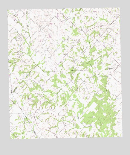
Greenvine, TX USGS Topographic Map
Click on map above to begin viewing in our Map Viewer.

This topographic map contains these locations and features:
Feature Name Type Latitude Longitude GNIS ID View Map
Bethlehem CemeteryCemeteryN30.1247°W96.5189°1330522View Map
Brushy CreekStreamN30.0466°W96.5661°1331431View Map
Burkhardt CemeteryCemeteryN30.0736°W96.6225°1331681View Map
Camp CreekStreamN30.1027°W96.6022°1331964View Map
GreenvinePopulated PlaceN30.1149°W96.5583°1336989View Map
Harmonie ParkParkN30.0213°W96.6008°1337359View Map
Historical MarkerParkN30.0386°W96.6050°1337839View Map
Jaeger-Witte CemeteryCemeteryN30.0949°W96.6128°1338616View Map
LatiumPopulated PlaceN30.0805°W96.5605°1378567View Map
Latium CemeteryCemeteryN30.0866°W96.5805°1339711View Map
Loftin LakeReservoirN30.1109°W96.5769°1865430View Map
Loftin Lake DamDamN30.1102°W96.5752°1865429View Map
Mayer CemeteryCemeteryN30.0816°W96.6136°1341107View Map
Pond CreekStreamN30.0727°W96.5655°1344340View Map
Rabb and Nobra AirportAirportN30.0040°W96.5803°2675864View Map
Sachse Public LibraryBuildingN30.0444°W96.6022°2014811View Map
Sandy BranchStreamN30.0419°W96.5291°1346580View Map
Schmidt CemeteryCemeteryN30.0005°W96.5583°1346770View Map
ShelbyPopulated PlaceN30.0216°W96.5983°1347010View Map
Skull CreekStreamN30.0108°W96.5416°1347212View Map
Sunnyvale Public LibraryBuildingN30.0722°W96.5936°2014726View Map
WesleyPopulated PlaceN30.0702°W96.5019°1349658View Map
Witte-Schmid HouseBuildingN30.0022°W96.5608°2032384View Map

Note: Coordinates in the location and feature list above are referenced to NAD83 datum.


Copyright (C) 2008-2024 Ryan Niemi / Sunset Dynamics ... All Rights Reserved