TopoQuest Logo
Do you find TopoQuest useful?
Help keep TopoQuest running and adding new maps/features by donating!
Bitcoin:  19c7KJd3qBynnjoSw5npx9KScwjBe4ifkT
Litecoin:  LXs6TkuXGGXo1vDsWCkWVdjQX94eUKd6ui
Home View Maps Find Maps Find Places Resources & Links


New Ulm, Texas Topographic Map

USGS Map Title: New Ulm, TX
USGS Map MRC: 29096H4
DRG (GeoTIFF) Download: o29096h4.tif


Neighboring USGS Topographic Map Quads:


  Greenvine, TX  
30096A5
 

  Welcome, TX  
30096A4
 

  Kenney, TX  
30096A3
 

  Industry, TX  
29096H5
 

  New Ulm, TX  
29096H4
 

  Bellville, TX  
29096H3
 

  Frelsburg, TX  
29096G5
 

  Bernardo, TX  
29096G4
 

  Cat Spring, TX  
29096G3


Map MRC Location:

N30°
W97°
N30°
W96°
H8 H7 H6 H5 H4 H3 H2 H1
G8 G7 G6 G5 G4 G3 G2 G1
F8 F7 F6 F5 F4 F3 F2 F1
E8 E7 E6 E5 E4 E3 E2 E1
D8 D7 D6 D5 D4 D3 D2 D1
C8 C7 C6 C5 C4 C3 C2 C1
B8 B7 B6 B5 B4 B3 B2 B1
A8 A7 A6 A5 A4 A3 A2 A1
N29°
W97°
N29°
W96°

New Ulm, TX USGS 1:24K Topographic Map Preview:
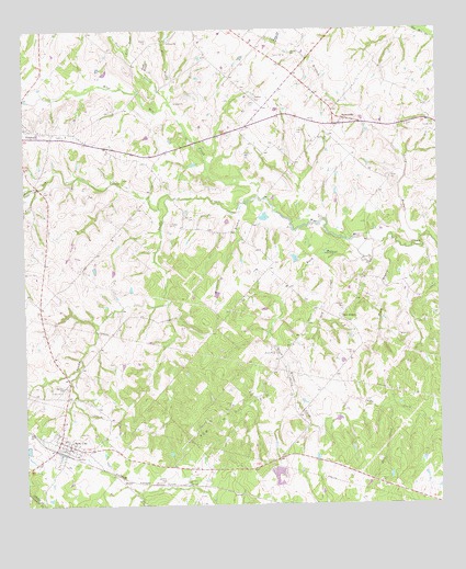
New Ulm, TX USGS Topographic Map
Click on map above to begin viewing in our Map Viewer.

This topographic map contains these locations and features:
Feature Name Type Latitude Longitude GNIS ID View Map
Bethany CemeteryCemeteryN29.9727°W96.4175°1351935View Map
Black BranchStreamN29.9438°W96.3880°1352284View Map
Black Walnut CreekStreamN29.9436°W96.3939°1352356View Map
Butler DamDamN29.8869°W96.4236°1856995View Map
Butler LakeReservoirN29.8869°W96.4236°1856996View Map
City of IndustryCivilN29.9715°W96.4991°2410103View Map
Deep CreekStreamN29.9005°W96.3905°1355806View Map
Dry CreekStreamN29.9408°W96.4064°1356295View Map
Frnka CemeteryCemeteryN29.9052°W96.4891°1357773View Map
GulfLocaleN29.8805°W96.4530°1358500View Map
Haedge CemeteryCemeteryN29.9941°W96.4191°1358618View Map
Heitman CemeteryCemeteryN29.9272°W96.4041°1359002View Map
Hoppe CemeteryCemeteryN29.9194°W96.3877°1359557View Map
Industry DivisionCivilN29.9610°W96.4545°1939315View Map
Long BranchStreamN29.9449°W96.3805°1374692View Map
Meckelroy BranchStreamN29.9547°W96.4333°1362564View Map
Mill BranchStreamN29.9822°W96.4564°1374933View Map
National CemeteryCemeteryN29.9822°W96.4305°1363605View Map
NelsonvillePopulated PlaceN29.9766°W96.4033°1363667View Map
Nelsonville CemeteryCemeteryN29.9708°W96.4083°1363668View Map
New BremenPopulated PlaceN29.9241°W96.4047°1380244View Map
New UlmPopulated PlaceN29.8922°W96.4902°1363801View Map
New Ulm CemeteryCemeteryN29.9063°W96.4880°1363802View Map
New Ulm Oil FieldOilfieldN29.8855°W96.4444°1375119View Map
New Ulm Post OfficePost OfficeN29.8902°W96.4887°2731495View Map
New Ulm Volunteer Fire DepartmentBuildingN29.8907°W96.4882°2552655View Map
Pastoren CreekStreamN29.9586°W96.4961°1364862View Map
Pecan BranchStreamN29.9805°W96.4558°1375389View Map
Pope CemeteryCemeteryN29.8941°W96.4844°1365584View Map
Post Oak Point CreekStreamN29.9563°W96.4561°1365662View Map
Rocky BranchStreamN29.9933°W96.4680°1375796View Map
Roesler HouseBuildingN29.9758°W96.4377°2032694View Map
Sandy CreekStreamN29.9563°W96.4297°1376005View Map
Star Hill CemeteryCemeteryN29.9505°W96.4489°1369110View Map
Stink BranchStreamN29.9844°W96.4591°1369209View Map
William Lewis Shelburne Farm CemeteryCemeteryN29.9674°W96.4336°1368120View Map
Zettel CemeteryCemeteryN29.9811°W96.4319°1372088View Map

Note: Coordinates in the location and feature list above are referenced to NAD83 datum.


Copyright (C) 2008-2025 Ryan Niemi / Sunset Dynamics ... All Rights Reserved