TopoQuest Logo
Do you find TopoQuest useful?
Help keep TopoQuest running and adding new maps/features by donating!
Bitcoin:  19c7KJd3qBynnjoSw5npx9KScwjBe4ifkT
Litecoin:  LXs6TkuXGGXo1vDsWCkWVdjQX94eUKd6ui
Home View Maps Find Maps Find Places Resources & Links


Griffin Butte, Idaho Topographic Map

USGS Map Title: Griffin Butte, ID
USGS Map MRC: 43114F4
DRG (GeoTIFF) Download: o43114f4.tif


Neighboring USGS Topographic Map Quads:


  Easley Hot Springs, ID  
43114G5
 

  Amber Lakes, ID  
43114G4
 

  Rock Roll Canyon, ID  
43114G3
 

  Boyle Mountain, ID  
43114F5
 

  Griffin Butte, ID  
43114F4
 

  Sun Valley, ID  
43114F3
 

  Buttercup Mountain, ID  
43114E5
 

  Mahoney Butte, ID  
43114E4
 

  Hailey, ID  
43114E3


Map MRC Location:

N44°
W115°
N44°
W114°
H8 H7 H6 H5 H4 H3 H2 H1
G8 G7 G6 G5 G4 G3 G2 G1
F8 F7 F6 F5 F4 F3 F2 F1
E8 E7 E6 E5 E4 E3 E2 E1
D8 D7 D6 D5 D4 D3 D2 D1
C8 C7 C6 C5 C4 C3 C2 C1
B8 B7 B6 B5 B4 B3 B2 B1
A8 A7 A6 A5 A4 A3 A2 A1
N43°
W115°
N43°
W114°

Griffin Butte, ID USGS 1:24K Topographic Map Preview:
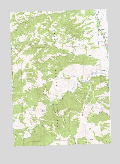
Griffin Butte, ID USGS Topographic Map
Click on map above to begin viewing in our Map Viewer.

This topographic map contains these locations and features:
Feature Name Type Latitude Longitude GNIS ID View Map
Adams GulchValleyN43.7044°W114.3764°399763View Map
Alturas GulchValleyN43.6502°W114.4662°376581View Map
Bald MountainSummitN43.6549°W114.4092°376878View Map
Bassett GulchValleyN43.6638°W114.4495°377024View Map
Cottonwood CampgroundLocaleN43.6574°W114.4587°379824View Map
Dip CreekStreamN43.7457°W114.3909°380599View Map
Dollar LakeLakeN43.6882°W114.4184°380702View Map
Eve GulchValleyN43.7094°W114.4248°381511View Map
Griffin ButteSummitN43.7299°W114.4198°382683View Map
Guyer Hot SpringsSpringN43.6832°W114.4106°382782View Map
KECH-FM (Sun Valley)TowerN43.6616°W114.4028°401803View Map
Ketchum Fire Department Station 3BuildingN43.7154°W114.3771°2619283View Map
KSKI-FM (Sun Valley)TowerN43.6432°W114.3978°401802View Map
KSKI-FM (Sun Valley)TowerN43.6616°W114.4028°401804View Map
Lake CreekStreamN43.7246°W114.3803°384359View Map
Moonlight GulchValleyN43.6744°W114.4606°387138View Map
Penny LakeLakeN43.6860°W114.4186°388336View Map
Red Warrior CreekStreamN43.6407°W114.4948°389248View Map
Warfield Hot SpringSpringN43.6412°W114.4874°392840View Map
Warm Springs CampgroundLocaleN43.6727°W114.4314°392878View Map
Warm Springs CreekStreamN43.6816°W114.3773°392887View Map
West Fork Warm Springs CreekStreamN43.6663°W114.4517°393218View Map

Note: Coordinates in the location and feature list above are referenced to NAD83 datum.


Copyright (C) 2008-2025 Ryan Niemi / Sunset Dynamics ... All Rights Reserved