TopoQuest Logo
Do you find TopoQuest useful?
Help keep TopoQuest running and adding new maps/features by donating!
Bitcoin:  19c7KJd3qBynnjoSw5npx9KScwjBe4ifkT
Litecoin:  LXs6TkuXGGXo1vDsWCkWVdjQX94eUKd6ui
Home View Maps Find Maps Find Places Resources & Links


Hailey, Idaho Topographic Map

USGS Map Title: Hailey, ID
USGS Map MRC: 43114E3
DRG (GeoTIFF) Download: o43114e3.tif


Neighboring USGS Topographic Map Quads:


  Griffin Butte, ID  
43114F4
 

  Sun Valley, ID  
43114F3
 

  Hyndman Peak, ID  
43114F2
 

  Mahoney Butte, ID  
43114E4
 

  Hailey, ID  
43114E3
 

  Baugh Creek SW, ID  
43114E2
 

  Richardson Summit, ID  
43114D4
 

  Bellevue, ID  
43114D3
 

  Seamans Creek, ID  
43114D2


Map MRC Location:

N44°
W115°
N44°
W114°
H8 H7 H6 H5 H4 H3 H2 H1
G8 G7 G6 G5 G4 G3 G2 G1
F8 F7 F6 F5 F4 F3 F2 F1
E8 E7 E6 E5 E4 E3 E2 E1
D8 D7 D6 D5 D4 D3 D2 D1
C8 C7 C6 C5 C4 C3 C2 C1
B8 B7 B6 B5 B4 B3 B2 B1
A8 A7 A6 A5 A4 A3 A2 A1
N43°
W115°
N43°
W114°

Hailey, ID USGS 1:24K Topographic Map Preview:
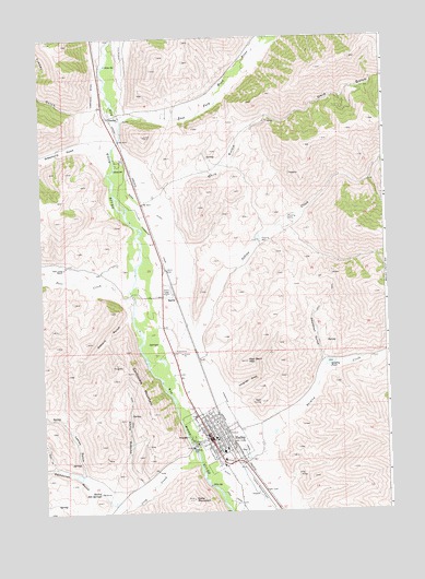
Hailey, ID USGS Topographic Map
Click on map above to begin viewing in our Map Viewer.

This topographic map contains these locations and features:
Feature Name Type Latitude Longitude GNIS ID View Map
BaritePopulated PlaceN43.5563°W114.3264°396071View Map
Blaine County Sheriff's OfficeBuildingN43.5050°W114.3022°2722468View Map
Carbonate MountainSummitN43.5369°W114.3428°371892View Map
City of HaileyCivilN43.5133°W114.3011°2410681View Map
Comstock DitchCanalN43.6110°W114.3550°379606View Map
Cove CanalCanalN43.5032°W114.3081°372185View Map
Croy CreekStreamN43.5121°W114.3195°380108View Map
Deadman GulchValleyN43.5402°W114.2737°372344View Map
Deer CreekStreamN43.5541°W114.3423°380435View Map
Deer Creek RanchLocaleN43.5646°W114.3670°372365View Map
Della MountainSummitN43.5032°W114.3220°372378View Map
Democrat GulchValleyN43.5049°W114.3550°380497View Map
East Fork Wood RiverStreamN43.6032°W114.3450°399863View Map
Friedman Memorial AirportAirportN43.5022°W114.2940°400830View Map
GimletPopulated PlaceN43.6041°W114.3498°396552View Map
Gimlet Airport (historical)AirportN43.6219°W114.3445°397327View Map
Greenhorn CreekStreamN43.5891°W114.3503°382658View Map
Greenhorn GulchValleyN43.5966°W114.3600°382660View Map
HaileyPopulated PlaceN43.5196°W114.3153°396603View Map
Hailey CemeteryCemeteryN43.5168°W114.3044°2766753View Map
Hailey Elementary SchoolSchoolN43.5157°W114.3099°401498View Map
Hailey Fire DepartmentBuildingN43.5156°W114.3079°2618998View Map
Hailey Hot SpringsSpringN43.5054°W114.3558°372958View Map
Hailey Police DepartmentBuildingN43.5189°W114.3152°2722392View Map
Hailey Post OfficePost OfficeN43.5122°W114.3079°2766873View Map
Hangman GulchValleyN43.5321°W114.3064°372976View Map
Hiawatha CanalCanalN43.5707°W114.3325°373059View Map
Indian CreekStreamN43.5480°W114.3203°373223View Map
Justus DitchCanalN43.5116°W114.3114°373375View Map
Ketchum Fire Department Station 2BuildingN43.5995°W114.3474°2619106View Map
KSKI-AM (Hailey)TowerN43.5580°W114.3323°401730View Map
Lambs GulchValleyN43.5107°W114.3612°373454View Map
Mizer DitchCanalN43.5805°W114.3342°373982View Map
Ohio GulchValleyN43.5852°W114.3303°374254View Map
Osborn GulchValleyN43.5505°W114.3453°374275View Map
Quigley CreekStreamN43.5207°W114.2925°374555View Map
Quigley PondLakeN43.5391°W114.2711°374556View Map
Red Devil MountainSummitN43.5396°W114.3017°374616View Map
Timber GulchValleyN43.6057°W114.3581°392153View Map
Vorberg GulchValleyN43.5085°W114.3420°375703View Map
Wood River Fire Protection District Station 1BuildingN43.5188°W114.3121°2619083View Map
Wood River Fire Protection District Station 2BuildingN43.5151°W114.3075°2619103View Map
Wood River High SchoolSchoolN43.5172°W114.2935°399683View Map
Wood River Middle SchoolSchoolN43.5285°W114.3171°399690View Map

Note: Coordinates in the location and feature list above are referenced to NAD83 datum.


Copyright (C) 2008-2025 Ryan Niemi / Sunset Dynamics ... All Rights Reserved