TopoQuest Logo
Do you find TopoQuest useful?
Help keep TopoQuest running and adding new maps/features by donating!
Bitcoin:  19c7KJd3qBynnjoSw5npx9KScwjBe4ifkT
Litecoin:  LXs6TkuXGGXo1vDsWCkWVdjQX94eUKd6ui
Home View Maps Find Maps Find Places Resources & Links


Grosfield Ranch, Montana Topographic Map

USGS Map Title: Grosfield Ranch, MT
USGS Map MRC: 45110H1
DRG (GeoTIFF) Download: o45110h1.tif


Neighboring USGS Topographic Map Quads:


  Amelong Creek, MT  
46110A2
 

  Battleship Butte, MT  
46110A1
 

  Melville, MT  
46109A8
 

  Raspberry Butte, MT  
45110H2
 

  Grosfield Ranch, MT  
45110H1
 

  Otter Creek School, MT  
45109H8
 

  Kelly Hills, MT  
45110G2
 

  Carney, MT  
45110G1
 

  Big Timber, MT  
45109G8


Map MRC Location:

N46°
W111°
N46°
W110°
H8 H7 H6 H5 H4 H3 H2 H1
G8 G7 G6 G5 G4 G3 G2 G1
F8 F7 F6 F5 F4 F3 F2 F1
E8 E7 E6 E5 E4 E3 E2 E1
D8 D7 D6 D5 D4 D3 D2 D1
C8 C7 C6 C5 C4 C3 C2 C1
B8 B7 B6 B5 B4 B3 B2 B1
A8 A7 A6 A5 A4 A3 A2 A1
N45°
W111°
N45°
W110°

Grosfield Ranch, MT USGS 1:24K Topographic Map Preview:
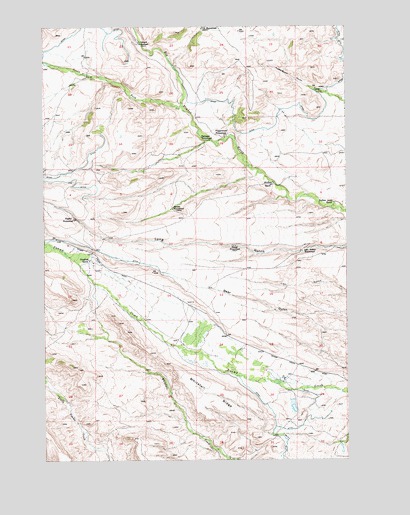
Grosfield Ranch, MT USGS Topographic Map
Click on map above to begin viewing in our Map Viewer.

This topographic map contains these locations and features:
Feature Name Type Latitude Longitude GNIS ID View Map
02N13E14____01 WellWellN45.9233°W110.0744°813381View Map
02N14E05____01 WellWellN45.9522°W110.0116°813534View Map
02N14E30____01 WellWellN45.8944°W110.0327°813169View Map
03N13E25____01 WellWellN45.9808°W110.0519°813673View Map
03N14E29____01 WellWellN45.9808°W110.0099°813672View Map
Big Timber CanyonValleyN45.9805°W110.0071°768832View Map
Buffalo Jump RanchLocaleN45.9488°W110.0060°769355View Map
Burns DamDamN45.8899°W110.0257°795366View Map
Devil CreekStreamN45.9944°W110.0844°782318View Map
Grosfield RanchLocaleN45.9327°W110.1069°772011View Map
Hauge HomesteadLocaleN45.9366°W110.0471°772201View Map
Hegdal HomesteadLocaleN45.9447°W110.1130°772309View Map
Iverson HomesteadLocaleN45.9480°W110.0724°772747View Map
John Nelson HomesteadLocaleN45.9352°W110.0194°772846View Map
Langus HomesteadLocaleN45.9958°W110.0852°773221View Map
Plaggemeyer HomesteadLocaleN45.9688°W110.0499°775277View Map
South Fork Big Timber CreekStreamN45.9772°W110.0682°790908View Map
Tintinger HomesteadLocaleN45.9680°W110.0602°777680View Map
Vik HomesteadLocaleN45.9997°W110.0596°778026View Map
Whitetail RidgeRidgeN45.8941°W110.0574°778428View Map
Whitney RanchLocaleN45.9541°W110.0316°778440View Map
Wormser (historical)Populated PlaceN45.9772°W110.0005°1743391View Map
Wormser Post Office (historical)Post OfficeN45.9772°W110.0005°1743423View Map
Wormser School (historical)SchoolN45.9772°W110.0005°778699View Map

Note: Coordinates in the location and feature list above are referenced to NAD83 datum.


Copyright (C) 2008-2025 Ryan Niemi / Sunset Dynamics ... All Rights Reserved