TopoQuest Logo
Do you find TopoQuest useful?
Help keep TopoQuest running and adding new maps/features by donating!
Bitcoin:  19c7KJd3qBynnjoSw5npx9KScwjBe4ifkT
Litecoin:  LXs6TkuXGGXo1vDsWCkWVdjQX94eUKd6ui
Home View Maps Find Maps Find Places Resources & Links


Maringouin, Louisiana Topographic Map

USGS Map Title: Maringouin, LA
USGS Map MRC: 30091D5
DRG (GeoTIFF) Download: o30091d5.tif


Neighboring USGS Topographic Map Quads:


  Lottie, LA  
30091E6
 

  Fordoche, LA  
30091E5
 

  Erwinville, LA  
30091E4
 

  Maringouin NW, LA  
30091D6
 

  Maringouin, LA  
30091D5
 

  Grosse Tete, LA  
30091D4
 

  Butte La Rose, LA  
30091C6
 

  Cow Bayou, LA  
30091C5
 

  Grosse Tete SW, LA  
30091C4


Map MRC Location:

N31°
W92°
N31°
W91°
H8 H7 H6 H5 H4 H3 H2 H1
G8 G7 G6 G5 G4 G3 G2 G1
F8 F7 F6 F5 F4 F3 F2 F1
E8 E7 E6 E5 E4 E3 E2 E1
D8 D7 D6 D5 D4 D3 D2 D1
C8 C7 C6 C5 C4 C3 C2 C1
B8 B7 B6 B5 B4 B3 B2 B1
A8 A7 A6 A5 A4 A3 A2 A1
N30°
W92°
N30°
W91°

Maringouin, LA USGS 1:24K Topographic Map Preview:
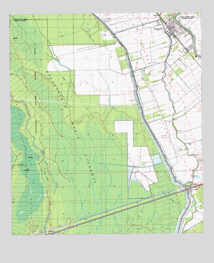
Maringouin, LA USGS Topographic Map
Click on map above to begin viewing in our Map Viewer.

This topographic map contains these locations and features:
Feature Name Type Latitude Longitude GNIS ID View Map
Bayou BlackStreamN30.3919°W91.5790°532449View Map
Bayou BurronStreamN30.4305°W91.5896°532475View Map
Bethany ChurchChurchN30.4985°W91.5179°532966View Map
Big IslandIslandN30.4069°W91.6007°533081View Map
Big Island ChuteStreamN30.3930°W91.5996°533087View Map
Brown BayouStreamN30.4999°W91.5693°553783View Map
Cross BayouStreamN30.4041°W91.5843°534272View Map
Des GlaisePopulated PlaceN30.3774°W91.6021°558206View Map
Des Ourses SwampSwampN30.4199°W91.6148°534506View Map
Dixie BayouStreamN30.4369°W91.5371°534537View Map
Full Gospel ChurchChurchN30.4335°W91.5165°1630000View Map
Greater Bethany Baptist CemeteryCemeteryN30.4984°W91.5170°2774690View Map
Happytown Oil and Gas FieldOilfieldN30.4094°W91.6184°542795View Map
Iberville Parish Library Maringouin BranchBuildingN30.4893°W91.5113°2603072View Map
Iberville Parish Sheriff's Office Maringouin SubstationBuildingN30.4896°W91.5120°2334248View Map
Immaculate Heart of Mary CemeteryCemeteryN30.4914°W91.5225°2776785View Map
Interchange 135CrossingN30.4005°W91.5057°541399View Map
Kenmore Oil and Gas FieldOilfieldN30.4907°W91.5626°554919View Map
Lower Maringouin School (historical)SchoolN30.4160°W91.5037°557151View Map
MaringouinPopulated PlaceN30.4913°W91.5196°536897View Map
Maringouin Post OfficePost OfficeN30.4925°W91.5185°1632111View Map
Maringouin Volunteer Fire DepartmentBuildingN30.4912°W91.5181°2332558View Map
Maringouin Wastewater Treatment FacilityLocaleN30.4773°W91.5070°2603470View Map
MussonPopulated PlaceN30.4394°W91.5193°543503View Map
Musson Gas FieldOilfieldN30.4316°W91.5246°557164View Map
New Zion Baptist CemeteryCemeteryN30.4763°W91.5082°557167View Map
New Zion ChurchChurchN30.4782°W91.5087°1629970View Map
North Iberville Head Start Center SchoolSchoolN30.4791°W91.5059°2600245View Map
RamahPopulated PlaceN30.4024°W91.5073°538486View Map
Rising Star Baptist CemeteryCemeteryN30.4066°W91.5062°2774717View Map
Rising Star ChurchChurchN30.4066°W91.5062°1630002View Map
Saint Peter CemeteryCemeteryN30.4719°W91.5271°539046View Map
Saint Stephens Episcopal CemeteryCemeteryN30.4963°W91.5257°2776789View Map
Shiloh ChurchChurchN30.4191°W91.5054°539340View Map
Shiloh Church CemeteryCemeteryN30.4195°W91.5061°2774691View Map
SparksPopulated PlaceN30.4988°W91.5273°543687View Map
Sweet Home Baptist CemeteryCemeteryN30.4936°W91.5238°2776790View Map
Tanglewood Plantation (historical)LocaleN30.4941°W91.5159°557217View Map
Tight IslandIslandN30.4221°W91.6040°539932View Map
Town of MaringouinCivilN30.4907°W91.5186°2406099View Map
Ward NineCivilN30.4780°W91.5240°545056View Map
West Oak Lane CemeteryCemeteryN30.4384°W91.5199°558355View Map
Woodlawn Plantation (historical)LocaleN30.4913°W91.5196°557227View Map

Note: Coordinates in the location and feature list above are referenced to NAD83 datum.


Copyright (C) 2008-2025 Ryan Niemi / Sunset Dynamics ... All Rights Reserved