TopoQuest Logo
Do you find TopoQuest useful?
Help keep TopoQuest running and adding new maps/features by donating!
Bitcoin:  19c7KJd3qBynnjoSw5npx9KScwjBe4ifkT
Litecoin:  LXs6TkuXGGXo1vDsWCkWVdjQX94eUKd6ui
Home View Maps Find Maps Find Places Resources & Links


Aulander, North Carolina Topographic Map

USGS Map Title: Aulander, NC
USGS Map MRC: 36077B1
DRG (GeoTIFF) Download: o36077b1.tif


Neighboring USGS Topographic Map Quads:


  Woodland, NC  
36077C2
 

  Union, NC  
36077C1
 

  Ahoskie, NC  
36076C8
 

  Kelford, NC  
36077B2
 

  Aulander, NC  
36077B1
 

  Powellsville, NC  
36076B8
 

  Lewiston Woodville, NC  
36077A2
 

  Republican, NC  
36077A1
 

  Windsor North, NC  
36076A8


Map MRC Location:

N37°
W78°
N37°
W77°
H8 H7 H6 H5 H4 H3 H2 H1
G8 G7 G6 G5 G4 G3 G2 G1
F8 F7 F6 F5 F4 F3 F2 F1
E8 E7 E6 E5 E4 E3 E2 E1
D8 D7 D6 D5 D4 D3 D2 D1
C8 C7 C6 C5 C4 C3 C2 C1
B8 B7 B6 B5 B4 B3 B2 B1
A8 A7 A6 A5 A4 A3 A2 A1
N36°
W78°
N36°
W77°

Aulander, NC USGS 1:24K Topographic Map Preview:
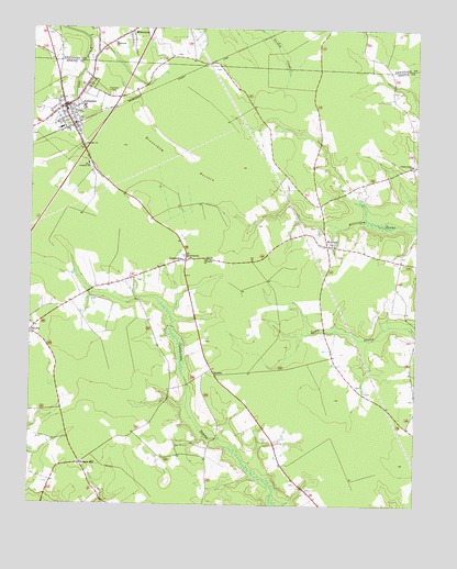
Aulander, NC USGS Topographic Map
Click on map above to begin viewing in our Map Viewer.

This topographic map contains these locations and features:
Feature Name Type Latitude Longitude GNIS ID View Map
AulanderPopulated PlaceN36.2296°W77.1141°1018874View Map
Aulander ChurchChurchN36.2193°W77.1077°980368View Map
Aulander Police DepartmentBuildingN36.2293°W77.1153°2130970View Map
Aulander Post OfficePost OfficeN36.2290°W77.1150°2773796View Map
Aulander Rescue SquadBuildingN36.2284°W77.1136°2720354View Map
Beaverdam PocosinSwampN36.2154°W77.0772°980859View Map
BurdenPopulated PlaceN36.1590°W77.0647°1006147View Map
Center Grove ChurchChurchN36.2146°W77.0013°982938View Map
Conconary ChurchChurchN36.1896°W77.0683°983421View Map
ConnaritsaPopulated PlaceN36.1893°W77.0747°1019756View Map
Connaritsa ChurchChurchN36.1902°W77.0741°983457View Map
Connaritsa PocosinSwampN36.2107°W77.1158°1004836View Map
Eastview CemeteryCemeteryN36.2326°W77.0991°984572View Map
Francis MillPopulated PlaceN36.1360°W77.1080°1006208View Map
Hearts Delight PocosinSwampN36.2302°W77.0733°1004837View Map
HexlenaPopulated PlaceN36.1932°W77.0288°1020696View Map
Metropolitan Interdenominational Church of GodChurchN36.2297°W77.1151°2505520View Map
MillenniumPopulated PlaceN36.2488°W77.0939°1021462View Map
Millennium ChurchChurchN36.2465°W77.0983°989992View Map
Millennium Fire DepartmentBuildingN36.2471°W77.0983°2638072View Map
RhodesPopulated PlaceN36.1704°W77.1241°1006348View Map
South Aulander SchoolSchoolN36.2146°W77.1064°995123View Map
Town of AulanderCivilN36.2280°W77.1136°2405185View Map
Township of MitchellCivilN36.1864°W77.0172°1026415View Map

Note: Coordinates in the location and feature list above are referenced to NAD83 datum.


Copyright (C) 2008-2024 Ryan Niemi / Sunset Dynamics ... All Rights Reserved