TopoQuest Logo
Do you find TopoQuest useful?
Help keep TopoQuest running and adding new maps/features by donating!
Bitcoin:  19c7KJd3qBynnjoSw5npx9KScwjBe4ifkT
Litecoin:  LXs6TkuXGGXo1vDsWCkWVdjQX94eUKd6ui
Home View Maps Find Maps Find Places Resources & Links


Kelford, North Carolina Topographic Map

USGS Map Title: Kelford, NC
USGS Map MRC: 36077B2
DRG (GeoTIFF) Download: o36077b2.tif


Neighboring USGS Topographic Map Quads:


  Rich Square, NC  
36077C3
 

  Woodland, NC  
36077C2
 

  Union, NC  
36077C1
 

  Norfleet, NC  
36077B3
 

  Kelford, NC  
36077B2
 

  Aulander, NC  
36077B1
 

  Palmyra, NC  
36077A3
 

  Lewiston Woodville, NC  
36077A2
 

  Republican, NC  
36077A1


Map MRC Location:

N37°
W78°
N37°
W77°
H8 H7 H6 H5 H4 H3 H2 H1
G8 G7 G6 G5 G4 G3 G2 G1
F8 F7 F6 F5 F4 F3 F2 F1
E8 E7 E6 E5 E4 E3 E2 E1
D8 D7 D6 D5 D4 D3 D2 D1
C8 C7 C6 C5 C4 C3 C2 C1
B8 B7 B6 B5 B4 B3 B2 B1
A8 A7 A6 A5 A4 A3 A2 A1
N36°
W78°
N36°
W77°

Kelford, NC USGS 1:24K Topographic Map Preview:
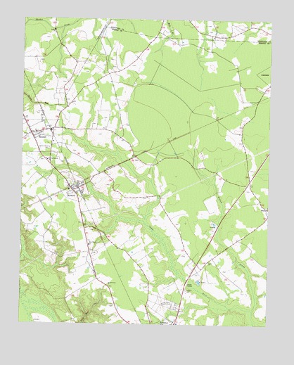
Kelford, NC USGS Topographic Map
Click on map above to begin viewing in our Map Viewer.

This topographic map contains these locations and features:
Feature Name Type Latitude Longitude GNIS ID View Map
Beautiful Zion ChurchChurchN36.1407°W77.2050°980783View Map
Hoggard CemeteryCemeteryN36.1393°W77.1661°986904View Map
KelfordPopulated PlaceN36.1796°W77.2236°987893View Map
Kelford Post OfficePost OfficeN36.1802°W77.2245°2505377View Map
Kelford Volunteer Fire DepartmentBuildingN36.1812°W77.2251°2638491View Map
Luella ChurchChurchN36.1510°W77.1547°989121View Map
Peanut Belt Research StationLocaleN36.1338°W77.1705°991989View Map
RoxobelPopulated PlaceN36.2029°W77.2452°1022434View Map
Roxobel Post OfficePost OfficeN36.2030°W77.2460°2773936View Map
Roxobel Volunteer Fire DepartmentBuildingN36.2016°W77.2445°2638436View Map
Roxobel-Kelford CemeteryCemeteryN36.1971°W77.2358°993781View Map
Roxobel-Kelford SchoolSchoolN36.1924°W77.2366°993782View Map
Town of KelfordCivilN36.1812°W77.2243°2405932View Map
Town of RoxobelCivilN36.2015°W77.2398°2407254View Map
Township of RoxobelCivilN36.1868°W77.2014°1026416View Map
Wahtom PocosinSwampN36.2179°W77.1844°1004840View Map
Wahtom SwampStreamN36.1307°W77.1322°996672View Map
West Bertie SchoolSchoolN36.1577°W77.2152°996988View Map

Note: Coordinates in the location and feature list above are referenced to NAD83 datum.


Copyright (C) 2008-2025 Ryan Niemi / Sunset Dynamics ... All Rights Reserved