TopoQuest Logo
Do you find TopoQuest useful?
Help keep TopoQuest running and adding new maps/features by donating!
Bitcoin:  19c7KJd3qBynnjoSw5npx9KScwjBe4ifkT
Litecoin:  LXs6TkuXGGXo1vDsWCkWVdjQX94eUKd6ui
Home View Maps Find Maps Find Places Resources & Links


Guerneville, California Topographic Map

USGS Map Title: Guerneville, CA
USGS Map MRC: 38122E8
DRG (GeoTIFF) Download: o38122e8.tif


Neighboring USGS Topographic Map Quads:


  Warm Springs Dam, CA  
38123F1
 

  Geyserville, CA  
38122F8
 

  Jimtown, CA  
38122F7
 

  Cazadero, CA  
38123E1
 

  Guerneville, CA  
38122E8
 

  Healdsburg, CA  
38122E7
 

  Duncans Mills, CA  
38123D1
 

  Camp Meeker, CA  
38122D8
 

  Sebastopol, CA  
38122D7


Map MRC Location:

N39°
W123°
N39°
W122°
H8 H7 H6 H5 H4 H3 H2 H1
G8 G7 G6 G5 G4 G3 G2 G1
F8 F7 F6 F5 F4 F3 F2 F1
E8 E7 E6 E5 E4 E3 E2 E1
D8 D7 D6 D5 D4 D3 D2 D1
C8 C7 C6 C5 C4 C3 C2 C1
B8 B7 B6 B5 B4 B3 B2 B1
A8 A7 A6 A5 A4 A3 A2 A1
N38°
W123°
N38°
W122°

Guerneville, CA USGS 1:24K Topographic Map Preview:
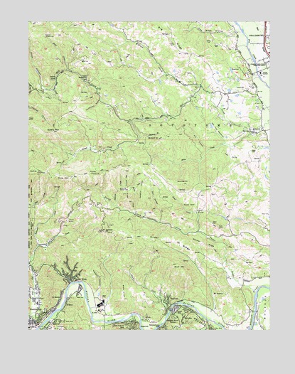
Guerneville, CA USGS Topographic Map
Click on map above to begin viewing in our Map Viewer.

This topographic map contains these locations and features:
Feature Name Type Latitude Longitude GNIS ID View Map
Angel CreekStreamN38.6055°W122.9806°256250View Map
Bear FlatFlatN38.5977°W122.9653°256658View Map
Black MountainSummitN38.5263°W122.9261°257133View Map
Boyd CreekStreamN38.5974°W122.9878°257419View Map
Brady RidgeRidgeN38.5149°W122.9517°257432View Map
Buzzard SpringSpringN38.5780°W122.9391°257787View Map
Camp RosenbergLocaleN38.6016°W122.9722°257892View Map
Cedar OpeningGapN38.6205°W122.9903°258141View Map
Christian Family Center Pentecostal Church of GodChurchN38.6080°W122.8778°1657233View Map
Coldwater GulchValleyN38.5932°W122.9633°258580View Map
Coyote KnollSummitN38.5505°W122.9169°1658333View Map
Daniels SchoolLocaleN38.6021°W122.9861°259042View Map
Davis Bynum WineryLocaleN38.5230°W122.8789°1799196View Map
Denner RidgeRidgeN38.5352°W122.9094°222264View Map
Department of Forestry and Fire Protection Hilton StationBuildingN38.5071°W122.9562°2624585View Map
East Ridge TrailTrailN38.5444°W123.0000°1799199View Map
El BonitaPopulated PlaceN38.5121°W122.9839°1658479View Map
Felta CreekStreamN38.5807°W122.8828°223436View Map
Felta SchoolSchoolN38.5805°W122.8805°223437View Map
Forest HillsPopulated PlaceN38.5080°W122.9244°1658560View Map
Fox CanyonValleyN38.5727°W122.9081°223775View Map
Gilder RidgeRidgeN38.5360°W122.9261°224164View Map
Green Valley CreekStreamN38.5046°W122.9086°224576View Map
GuernevillePopulated PlaceN38.5019°W122.9961°277527View Map
Guerneville Branch Sonoma County Public LibraryBuildingN38.5035°W122.9972°1799214View Map
Guerneville BridgeBridgeN38.5007°W122.9953°1799215View Map
Guerneville Census Designated PlaceCensusN38.5137°W122.9894°2408341View Map
Guerneville Community ChurchChurchN38.5088°W122.9961°1799216View Map
Guerneville Community Day SchoolSchoolN38.5104°W122.9963°2517882View Map
Guerneville Elementary SchoolSchoolN38.5111°W122.9963°1799217View Map
HaciendaPopulated PlaceN38.5113°W122.9278°1658691View Map
Healdsburg DivisionCivilN38.6002°W122.8865°1935132View Map
Healdsburg Post OfficePost OfficeN38.6142°W122.8776°1799229View Map
HighcroftPopulated PlaceN38.5019°W122.9436°1658747View Map
HiltonPopulated PlaceN38.5046°W122.9403°225352View Map
Hobson CreekStreamN38.5071°W122.9272°225380View Map
HollydalePopulated PlaceN38.5052°W122.9200°1658767View Map
Inman Shale QuarryMineN38.6003°W122.9150°2678018View Map
John Gordon CreekStreamN38.5435°W122.9325°226268View Map
Junction SchoolSchoolN38.5955°W122.9044°226383View Map
KMGG-FM (Monte Rio)TowerN38.5399°W122.9619°1662975View Map
KorbelPopulated PlaceN38.5077°W122.9644°226677View Map
Korbel WineryLocaleN38.5102°W122.9636°1799238View Map
KXFX-FM (Santa Rosa)TowerN38.5410°W122.9028°1663093View Map
Lafayette SchoolLocaleN38.5105°W122.8880°226757View Map
McCray MountainSummitN38.5638°W122.9933°228333View Map
McPeak CemeteryCemeteryN38.5098°W122.9281°1657207View Map
Mill Creek VineyardsLocaleN38.6027°W122.8872°1799249View Map
Mount JacksonSummitN38.5394°W122.9603°226103View Map
Mount JacksonPopulated PlaceN38.5132°W122.9050°1659187View Map
Newgate RidgeRidgeN38.5569°W122.9411°229516View Map
Odd Fellows ParkPopulated PlaceN38.5021°W122.9472°1659283View Map
Osborne CreekStreamN38.5502°W122.9547°230134View Map
Palmer CreekStreamN38.5844°W122.9475°230265View Map
Pasquini CanyonValleyN38.5155°W122.9656°230390View Map
Pickle CanyonValleyN38.5977°W122.9922°230620View Map
Pine Ridge CanyonValleyN38.6205°W122.8936°230719View Map
Pocket OpeningGapN38.5630°W122.9672°230839View Map
Porter CreekStreamN38.5152°W122.8830°230951View Map
Press CreekStreamN38.5399°W122.9128°231039View Map
Press ValleyBasinN38.5477°W122.9133°231040View Map
Queens PeakSummitN38.5807°W122.9875°231134View Map
Redwood CreekStreamN38.5269°W123.0000°231420View Map
Redwood Memorial GardensCemeteryN38.5080°W122.9922°1989448View Map
Renevar GulchValleyN38.5777°W122.9425°231493View Map
Ridenhour SchoolSchoolN38.5069°W122.9556°231563View Map
Rio NidoPopulated PlaceN38.5210°W122.9769°1659515View Map
Rio Nido Post OfficePost OfficeN38.5214°W122.9817°1799261View Map
Rocky MountainSummitN38.5616°W122.9792°1659536View Map
RolandsPopulated PlaceN38.5107°W122.9806°1659540View Map
Russian River Fire Protection DistrictBuildingN38.5034°W122.9979°2624138View Map
Russian River TerracePopulated PlaceN38.5046°W122.9267°1659562View Map
Saint Elizabeths Roman Catholic ChurchChurchN38.5032°W122.9972°1799268View Map
Scotts CreekStreamN38.5471°W122.9456°232735View Map
Scotts OpeningGapN38.5560°W122.9503°232737View Map
Scotts RidgeRidgeN38.5546°W122.9497°232738View Map
Sonoma CountyCivilN38.5253°W122.9225°1657246View Map
Sonoma County Sheriff's Office - Guerneville SubstationBuildingN38.5012°W122.9982°2755750View Map
Sonoma MineMineN38.5438°W122.9792°234884View Map
Sweetwater CreekStreamN38.5338°W122.9964°1657208View Map
The LadderSlopeN38.5966°W122.9956°1657206View Map
The MeadowsFlatN38.5791°W122.9019°236191View Map
Veterans Memorial BuildingBuildingN38.5010°W122.9983°1799283View Map
Wallace CreekStreamN38.6249°W122.9628°237193View Map
West Side Elementary SchoolSchoolN38.5799°W122.8834°1657232View Map
Wild Hog HillSummitN38.5596°W122.9203°237754View Map

Note: Coordinates in the location and feature list above are referenced to NAD83 datum.


Copyright (C) 2008-2024 Ryan Niemi / Sunset Dynamics ... All Rights Reserved