TopoQuest Logo
Do you find TopoQuest useful?
Help keep TopoQuest running and adding new maps/features by donating!
Bitcoin:  19c7KJd3qBynnjoSw5npx9KScwjBe4ifkT
Litecoin:  LXs6TkuXGGXo1vDsWCkWVdjQX94eUKd6ui
Home View Maps Find Maps Find Places Resources & Links


Reader, Arkansas Topographic Map

USGS Map Title: Reader, AR
USGS Map MRC: 33093G1
DRG (GeoTIFF) Download: o33093g1.tif


Neighboring USGS Topographic Map Quads:


  Gurdon, AR  
33093H2
 

  Curtis, AR  
33093H1
 

  Sparkman NW, AR  
33092H8
 

  Whelen Springs, AR  
33093G2
 

  Reader, AR  
33093G1
 

  Tates Bluff, AR  
33092G8
 

  Bluff City, AR  
33093F2
 

  Chidester, AR  
33093F1
 

  Bragg City, AR  
33092F8


Map MRC Location:

N34°
W94°
N34°
W93°
H8 H7 H6 H5 H4 H3 H2 H1
G8 G7 G6 G5 G4 G3 G2 G1
F8 F7 F6 F5 F4 F3 F2 F1
E8 E7 E6 E5 E4 E3 E2 E1
D8 D7 D6 D5 D4 D3 D2 D1
C8 C7 C6 C5 C4 C3 C2 C1
B8 B7 B6 B5 B4 B3 B2 B1
A8 A7 A6 A5 A4 A3 A2 A1
N33°
W94°
N33°
W93°

Reader, AR USGS 1:24K Topographic Map Preview:
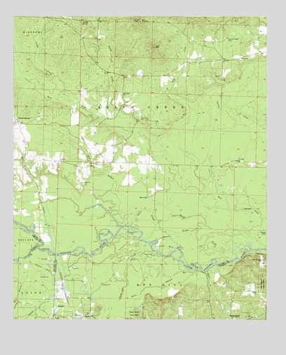
Reader, AR USGS Topographic Map
Click on map above to begin viewing in our Map Viewer.

This topographic map contains these locations and features:
Feature Name Type Latitude Longitude GNIS ID View Map
Beech CreekStreamN33.7784°W93.0099°46323View Map
Bethlehem Baptist ChurchChurchN33.8329°W93.0618°76322View Map
Bethlehem CemeteryCemeteryN33.8437°W93.0718°46466View Map
Boiling SpringsSpringN33.8726°W93.0882°46813View Map
Bolin SloughGutN33.7951°W93.0579°46820View Map
Bull MountainSummitN33.8737°W93.0629°47171View Map
Caney CreekStreamN33.7804°W93.1127°47417View Map
Cross Roads ChurchChurchN33.8570°W93.0218°48205View Map
East Whelen Baptist ChurchChurchN33.8143°W93.0838°76840View Map
Gores PeakSummitN33.8629°W93.0560°49517View Map
Henley BranchStreamN33.7743°W93.1229°50015View Map
Horn LakeLakeN33.8002°W93.0579°75738View Map
Horse BranchStreamN33.7698°W93.0366°50325View Map
Horseshoe BendBendN33.7807°W93.0496°50335View Map
Jenkins CemeteryCemeteryN33.8165°W93.0135°50616View Map
Lewis Randolph GraveCemeteryN33.8659°W93.0191°51081View Map
Locket CreekStreamN33.8426°W93.0996°51360View Map
Minnie SloughGutN33.7859°W93.0438°52094View Map
Missouri United Methodist ChurchChurchN33.7623°W93.0052°77676View Map
Polk Stinnett HillSummitN33.7748°W93.0021°58408View Map
ReaderPopulated PlaceN33.7521°W93.1052°78139View Map
Reader Census Designated PlaceCensusN33.7518°W93.1009°2612131View Map
Reader First Baptist ChurchChurchN33.7540°W93.1052°64406View Map
Reader Volunteer Fire DepartmentBuildingN33.7513°W93.1060°2117018View Map
Riffe FordCrossingN33.7723°W93.0354°58490View Map
Rocky BranchStreamN33.7887°W93.0710°54120View Map
Salt LakeLakeN33.7957°W93.0073°75843View Map
SayrePopulated PlaceN33.7521°W93.0921°57179View Map
Town of Reader (historical)CivilN33.7518°W93.1009°2407182View Map
Township of Beech Creek (historical)CivilN33.8348°W93.0404°65012View Map
West Fork Beech CreekStreamN33.8337°W93.0791°56177View Map
White Oak CreekStreamN33.7782°W93.0560°78755View Map

Note: Coordinates in the location and feature list above are referenced to NAD83 datum.


Copyright (C) 2008-2025 Ryan Niemi / Sunset Dynamics ... All Rights Reserved