TopoQuest Logo
Do you find TopoQuest useful?
Help keep TopoQuest running and adding new maps/features by donating!
Bitcoin:  19c7KJd3qBynnjoSw5npx9KScwjBe4ifkT
Litecoin:  LXs6TkuXGGXo1vDsWCkWVdjQX94eUKd6ui
Home View Maps Find Maps Find Places Resources & Links


Gypsum, Colorado Topographic Map

USGS Map Title: Gypsum, CO
USGS Map MRC: 39106F8
DRG (GeoTIFF) Download: o39106f8.tif


Neighboring USGS Topographic Map Quads:


  Sugarloaf Mountain, CO  
39107G1
 

  Burns South, CO  
39106G8
 

  Castle Peak, CO  
39106G7
 

  Dotsero, CO  
39107F1
 

  Gypsum, CO  
39106F8
 

  Eagle, CO  
39106F7
 

  Cottonwood Pass, CO  
39107E1
 

  Suicide Mountain, CO  
39106E8
 

  The Seven Hermits, CO  
39106E7


Map MRC Location:

N40°
W107°
N40°
W106°
H8 H7 H6 H5 H4 H3 H2 H1
G8 G7 G6 G5 G4 G3 G2 G1
F8 F7 F6 F5 F4 F3 F2 F1
E8 E7 E6 E5 E4 E3 E2 E1
D8 D7 D6 D5 D4 D3 D2 D1
C8 C7 C6 C5 C4 C3 C2 C1
B8 B7 B6 B5 B4 B3 B2 B1
A8 A7 A6 A5 A4 A3 A2 A1
N39°
W107°
N39°
W106°

Gypsum, CO USGS 1:24K Topographic Map Preview:
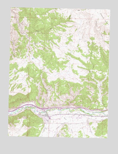
Gypsum, CO USGS Topographic Map
Click on map above to begin viewing in our Map Viewer.

This topographic map contains these locations and features:
Feature Name Type Latitude Longitude GNIS ID View Map
Agnew GulchValleyN39.7165°W106.9754°175846View Map
Alkali CreekStreamN39.6480°W106.8981°175850View Map
Casper Schumm DitchCanalN39.6508°W106.8989°175855View Map
Cedar Hill Memorial CemeteryCemeteryN39.6447°W106.9603°2107148View Map
Chatfield and Bartholomew DitchCanalN39.6269°W106.9412°202328View Map
Cottonwood CreekStreamN39.6478°W106.8762°175849View Map
Dry LakeLakeN39.7006°W106.9712°175847View Map
Eagle County Airport Fire DepartmentBuildingN39.6400°W106.9158°2667009View Map
Eagle County Ambulance DistrictBuildingN39.6464°W106.9352°2735530View Map
Eagle County Regional AirportAirportN39.6457°W106.9129°204373View Map
Greenhorn CreekStreamN39.7275°W106.9864°175844View Map
Greenhorn GulchValleyN39.7275°W106.9862°175770View Map
Greenhorn MountainSummitN39.7461°W106.8820°175778View Map
GypsumPopulated PlaceN39.6469°W106.9517°175853View Map
Gypsum CreekStreamN39.6494°W106.9528°175845View Map
Gypsum Fire Protection District Station 14BuildingN39.6441°W106.9528°2666850View Map
Gypsum Post OfficePost OfficeN39.6458°W106.9478°2734569View Map
McHatten CreekStreamN39.6261°W106.8881°175977View Map
Road GulchValleyN39.6528°W106.9558°175856View Map
Spring CreekStreamN39.6508°W106.9359°175851View Map
Stremme and Gates DitchCanalN39.6480°W106.9006°175854View Map
Tenderfoot GulchValleyN39.6285°W106.9350°175852View Map
Town of GypsumCivilN39.6362°W106.8997°2412716View Map
TriState Care FlightBuildingN39.6413°W106.9095°2735549View Map
West Fork Cottonwood CreekStreamN39.6769°W106.8867°175848View Map

Note: Coordinates in the location and feature list above are referenced to NAD83 datum.


Copyright (C) 2008-2024 Ryan Niemi / Sunset Dynamics ... All Rights Reserved