TopoQuest Logo
Do you find TopoQuest useful?
Help keep TopoQuest running and adding new maps/features by donating!
Bitcoin:  19c7KJd3qBynnjoSw5npx9KScwjBe4ifkT
Litecoin:  LXs6TkuXGGXo1vDsWCkWVdjQX94eUKd6ui
Home View Maps Find Maps Find Places Resources & Links


Suicide Mountain, Colorado Topographic Map

USGS Map Title: Suicide Mountain, CO
USGS Map MRC: 39106E8
DRG (GeoTIFF) Download: o39106e8.tif


Neighboring USGS Topographic Map Quads:


  Dotsero, CO  
39107F1
 

  Gypsum, CO  
39106F8
 

  Eagle, CO  
39106F7
 

  Cottonwood Pass, CO  
39107E1
 

  Suicide Mountain, CO  
39106E8
 

  The Seven Hermits, CO  
39106E7
 

  Leon, CO  
39107D1
 

  Toner Reservoir, CO  
39106D8
 

  Red Creek, CO  
39106D7


Map MRC Location:

N40°
W107°
N40°
W106°
H8 H7 H6 H5 H4 H3 H2 H1
G8 G7 G6 G5 G4 G3 G2 G1
F8 F7 F6 F5 F4 F3 F2 F1
E8 E7 E6 E5 E4 E3 E2 E1
D8 D7 D6 D5 D4 D3 D2 D1
C8 C7 C6 C5 C4 C3 C2 C1
B8 B7 B6 B5 B4 B3 B2 B1
A8 A7 A6 A5 A4 A3 A2 A1
N39°
W107°
N39°
W106°

Suicide Mountain, CO USGS 1:24K Topographic Map Preview:
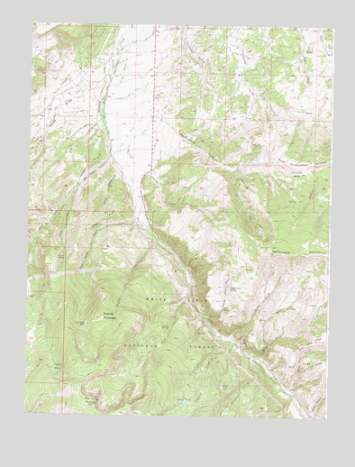
Suicide Mountain, CO USGS Topographic Map
Click on map above to begin viewing in our Map Viewer.

This topographic map contains these locations and features:
Feature Name Type Latitude Longitude GNIS ID View Map
Borah LakeLakeN39.5096°W106.9186°175996View Map
Cherry CreekStreamN39.5244°W106.9156°175982View Map
Daggett and Parker DitchCanalN39.6028°W106.9589°195286View Map
Dewey ParkFlatN39.5303°W106.9267°175995View Map
Dewey Park GulchValleyN39.5319°W106.9259°195273View Map
Dewey Park SpringSpringN39.5408°W106.9162°195272View Map
Dry Miller CreekStreamN39.5233°W106.8995°195270View Map
East Fork Old Mans GulchValleyN39.5749°W106.9786°175992View Map
Erickson CreekStreamN39.5194°W106.9073°175983View Map
Ferguson DitchCanalN39.5805°W106.9725°195282View Map
Fish Pond GulchValleyN39.5630°W106.9557°196603View Map
Fish Pond LakeLakeN39.5289°W106.9753°175985View Map
Gerard GulchValleyN39.5245°W106.9149°195271View Map
Gould CreekStreamN39.5389°W106.9314°175999View Map
Grundell CreekStreamN39.5919°W106.9409°195280View Map
Gypsum Creek CampgroundLocaleN39.5322°W106.9259°175997View Map
Gypsum Creek Ranch AirportAirportN39.5989°W106.9742°204437View Map
Hardscrabble GulchValleyN39.5965°W106.9479°195283View Map
Hardscrabble SaddleGapN39.5808°W106.8873°195281View Map
Ho O R DitchCanalN39.5861°W106.9603°195285View Map
McBrayer and Fenner DitchCanalN39.6167°W106.9664°195289View Map
McBrayer DitchCanalN39.6150°W106.9589°195288View Map
Miller DitchCanalN39.5667°W106.9523°195278View Map
Miller Gulch CreekStreamN39.5189°W106.9056°175978View Map
Mud SpringSpringN39.5345°W106.9189°175998View Map
North Hardscrabble MountainSummitN39.5814°W106.8903°202346View Map
Old Mans GulchValleyN39.5819°W106.9670°175991View Map
Owl GulchValleyN39.5084°W106.8898°175980View Map
Pot HoleBasinN39.5628°W106.9062°195276View Map
Quaker CorralLocaleN39.5447°W106.9884°195274View Map
Rock SpringSpringN39.5284°W106.9411°175993View Map
Slow Trail GulchValleyN39.5090°W106.8906°175979View Map
Snake GulchValleyN39.5778°W106.9634°195279View Map
Snake RidgeRidgeN39.5630°W106.9687°195277View Map
Spring GulchValleyN39.6086°W106.9670°174137View Map
Spruce SpringSpringN39.5499°W106.9848°195275View Map
Stratton DitchCanalN39.5861°W106.9587°195284View Map
Suicide MountainSummitN39.5311°W106.9692°175984View Map
Sundell CreekStreamN39.5569°W106.9475°175988View Map
Swamp DrainCanalN39.6111°W106.9620°195287View Map
The Beaver PondsLakeN39.5039°W106.9342°175994View Map
Timber BasinBasinN39.5153°W106.9862°175986View Map
West Fork Old Mans GulchValleyN39.5740°W106.9800°175990View Map
White River National ForestForestN39.5607°W106.8925°169576View Map
Yates GulchValleyN39.5005°W106.8826°175981View Map

Note: Coordinates in the location and feature list above are referenced to NAD83 datum.


Copyright (C) 2008-2025 Ryan Niemi / Sunset Dynamics ... All Rights Reserved