TopoQuest Logo
Do you find TopoQuest useful?
Help keep TopoQuest running and adding new maps/features by donating!
Bitcoin:  19c7KJd3qBynnjoSw5npx9KScwjBe4ifkT
Litecoin:  LXs6TkuXGGXo1vDsWCkWVdjQX94eUKd6ui
Home View Maps Find Maps Find Places Resources & Links


Hallsville, Missouri Topographic Map

USGS Map Title: Hallsville, MO
USGS Map MRC: 39092A2
DRG (GeoTIFF) Download: o39092a2.tif


Neighboring USGS Topographic Map Quads:


  Sturgeon, MO  
39092B3
 

  Centralia, MO  
39092B2
 

  Centralia NE, MO  
39092B1
 

  Browns, MO  
39092A3
 

  Hallsville, MO  
39092A2
 

  Hatton, MO  
39092A1
 

  Columbia, MO  
38092H3
 

  Millersburg, MO  
38092H2
 

  Millersburg NE, MO  
38092H1


Map MRC Location:

N40°
W93°
N40°
W92°
H8 H7 H6 H5 H4 H3 H2 H1
G8 G7 G6 G5 G4 G3 G2 G1
F8 F7 F6 F5 F4 F3 F2 F1
E8 E7 E6 E5 E4 E3 E2 E1
D8 D7 D6 D5 D4 D3 D2 D1
C8 C7 C6 C5 C4 C3 C2 C1
B8 B7 B6 B5 B4 B3 B2 B1
A8 A7 A6 A5 A4 A3 A2 A1
N39°
W93°
N39°
W92°

Hallsville, MO USGS 1:24K Topographic Map Preview:
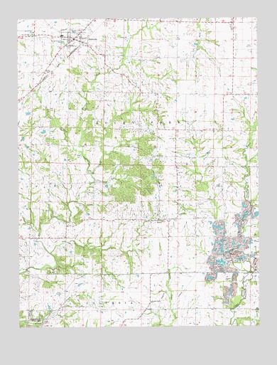
Hallsville, MO USGS Topographic Map
Click on map above to begin viewing in our Map Viewer.

This topographic map contains these locations and features:
Feature Name Type Latitude Longitude GNIS ID View Map
Andy LakeReservoirN39.1167°W92.2402°761678View Map
Andy Lake DamDamN39.1167°W92.2402°761677View Map
Boone County Fire Protection District Station 3BuildingN39.1139°W92.2251°2620582View Map
City of HallsvilleCivilN39.1185°W92.2265°2394270View Map
Cumminghams Lake DamDamN39.0334°W92.1918°762126View Map
Grand View School (historical)SchoolN39.0942°W92.1473°759432View Map
Grandview ChurchChurchN39.0453°W92.1666°750102View Map
HallsvillePopulated PlaceN39.1170°W92.2207°750202View Map
Hallsville High SchoolSchoolN39.1183°W92.2270°2571012View Map
Hallsville Intermediate SchoolSchoolN39.1183°W92.2255°2571010View Map
Hallsville Middle SchoolSchoolN39.1183°W92.2265°2571011View Map
Hallsville Police DepartmentBuildingN39.1172°W92.2217°2752276View Map
Hallsville Post OfficePost OfficeN39.1180°W92.2237°2782808View Map
Hallsville Primary SchoolSchoolN39.1212°W92.2357°2571009View Map
Hardin Field (historical)AirportN39.0934°W92.1960°758707View Map
Jones School (historical)SchoolN39.0445°W92.1863°759433View Map
Judy School (historical)SchoolN39.0072°W92.1678°759434View Map
Lebanon (historical)Populated PlaceN39.0695°W92.2210°759435View Map
Linn Lake DamDamN39.0450°W92.1268°761374View Map
Mount Hope ChurchChurchN39.0217°W92.2313°751180View Map
Mount Zion ChurchChurchN39.0692°W92.1793°751207View Map
MurryPopulated PlaceN39.0428°W92.1768°751245View Map
Murry School (historical)SchoolN39.0428°W92.1723°759380View Map
New Red Top ChurchChurchN39.1184°W92.2432°751304View Map
O'Rear School (historical)SchoolN39.0478°W92.2398°759381View Map
Oak CemeteryCemeteryN39.0063°W92.1258°753766View Map
Oak ChapelChurchN39.0064°W92.1255°751369View Map
Old Red Top ChurchChurchN39.1198°W92.2416°751424View Map
Owen School (historical)SchoolN39.1095°W92.1675°759382View Map
Points (historical)Populated PlaceN39.1023°W92.1555°759383View Map
Potts School (historical)SchoolN39.0253°W92.1713°759384View Map
Renfro CreekStreamN39.0217°W92.1310°751853View Map
Scott LakeReservoirN39.1159°W92.2371°762129View Map
Scott Lake DamDamN39.1167°W92.2368°762128View Map
Stephens CemeteryCemeteryN39.0190°W92.1428°752353View Map
Township of Rocky ForkCivilN39.0904°W92.2283°766335View Map
Two Mile PrairieAreaN39.0181°W92.1668°759385View Map
Two Mile Prairie Elementary SchoolSchoolN39.0098°W92.1818°752649View Map
Varnon BranchStreamN39.0709°W92.2168°752696View Map
Varnon School (historical)SchoolN39.0843°W92.2330°759386View Map
Wasley Lake DamDamN39.0867°W92.2435°762127View Map

Note: Coordinates in the location and feature list above are referenced to NAD83 datum.


Copyright (C) 2008-2025 Ryan Niemi / Sunset Dynamics ... All Rights Reserved