TopoQuest Logo
Do you find TopoQuest useful?
Help keep TopoQuest running and adding new maps/features by donating!
Bitcoin:  19c7KJd3qBynnjoSw5npx9KScwjBe4ifkT
Litecoin:  LXs6TkuXGGXo1vDsWCkWVdjQX94eUKd6ui
Home View Maps Find Maps Find Places Resources & Links


Sturgeon, Missouri Topographic Map

USGS Map Title: Sturgeon, MO
USGS Map MRC: 39092B3
DRG (GeoTIFF) Download: o39092b3.tif


Neighboring USGS Topographic Map Quads:


  Renick, MO  
39092C4
 

  Clark, MO  
39092C3
 

  Tulip, MO  
39092C2
 

  Harrisburg, MO  
39092B4
 

  Sturgeon, MO  
39092B3
 

  Centralia, MO  
39092B2
 

  Sturgeon SW, MO  
39092A4
 

  Browns, MO  
39092A3
 

  Hallsville, MO  
39092A2


Map MRC Location:

N40°
W93°
N40°
W92°
H8 H7 H6 H5 H4 H3 H2 H1
G8 G7 G6 G5 G4 G3 G2 G1
F8 F7 F6 F5 F4 F3 F2 F1
E8 E7 E6 E5 E4 E3 E2 E1
D8 D7 D6 D5 D4 D3 D2 D1
C8 C7 C6 C5 C4 C3 C2 C1
B8 B7 B6 B5 B4 B3 B2 B1
A8 A7 A6 A5 A4 A3 A2 A1
N39°
W93°
N39°
W92°

Sturgeon, MO USGS 1:24K Topographic Map Preview:
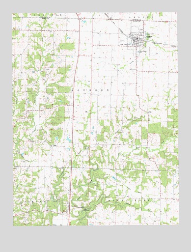
Sturgeon, MO USGS Topographic Map
Click on map above to begin viewing in our Map Viewer.

This topographic map contains these locations and features:
Feature Name Type Latitude Longitude GNIS ID View Map
Angel Lake DamDamN39.1784°W92.3418°762289View Map
Bailey Lake DamDamN39.1750°W92.3318°760225View Map
Baumgarner Brothers LakeReservoirN39.1484°W92.3685°761547View Map
Boone County Fire Protection District Station 6BuildingN39.2340°W92.2790°2621602View Map
BourbonPopulated PlaceN39.2389°W92.3146°759359View Map
Bumgarner Lake Section 11 DamDamN39.1434°W92.3468°762293View Map
Bumgarner Lake Section 3 DamDamN39.1484°W92.3685°761546View Map
City of SturgeonCivilN39.2345°W92.2825°2395992View Map
Country Box Estates Lake DamDamN39.1367°W92.3585°762294View Map
David Baliey LakeReservoirN39.1755°W92.3329°760226View Map
Flint School (historical)SchoolN39.1406°W92.3463°736194View Map
Grindstone BranchStreamN39.1253°W92.3441°718882View Map
Hawk Air Airport (historical)AirportN39.2035°W92.2627°2679393View Map
Kelley BranchStreamN39.1314°W92.3207°750569View Map
Locust Grove ChurchChurchN39.1703°W92.3188°721386View Map
Mount Carmel CemeteryCemeteryN39.1628°W92.3655°722729View Map
Mount Horeb CemeteryCemeteryN39.2159°W92.2843°722772View Map
Nailer CemeteryCemeteryN39.1589°W92.3371°723110View Map
North 40 Lake DamDamN39.1984°W92.3402°762288View Map
Palmer CemeteryCemeteryN39.1881°W92.2835°723974View Map
Petersburg (historical)Populated PlaceN39.1603°W92.3124°759413View Map
Pollock Lake DamDamN39.1700°W92.3052°762291View Map
RiggsPopulated PlaceN39.1712°W92.3455°741199View Map
Riggs CemeteryCemeteryN39.1917°W92.3185°725304View Map
Salmons Lake DamDamN39.1534°W92.3002°762292View Map
SturgeonPopulated PlaceN39.2342°W92.2807°727205View Map
Sturgeon CemeteryCemeteryN39.2331°W92.2938°727206View Map
Sturgeon Elementary SchoolSchoolN39.2335°W92.2835°2571018View Map
Sturgeon High SchoolSchoolN39.2441°W92.2840°2571020View Map
Sturgeon Middle SchoolSchoolN39.2333°W92.2826°2571019View Map
Sturgeon Post OfficePost OfficeN39.2347°W92.2821°2782689View Map
The PinnaclesSummitN39.1337°W92.3227°727568View Map
Thompson BranchStreamN39.1659°W92.3041°727592View Map
Tincher Lake NorthReservoirN39.2353°W92.3327°762325View Map
Tincher Lake North DamDamN39.2367°W92.3335°762324View Map
Tincher Lake SouthReservoirN39.2306°W92.3322°762768View Map
Tincher Lake South DamDamN39.2300°W92.3335°762767View Map
Township of BourbonCivilN39.2015°W92.3268°766329View Map
Tucker School (historical)SchoolN39.1942°W92.2885°736195View Map
Turner School (historical)SchoolN39.2264°W92.3432°759414View Map
Wayland Lake DamDamN39.1700°W92.3318°762290View Map
Winn School (historical)SchoolN39.1575°W92.2871°759415View Map
Woods School (historical)SchoolN39.1750°W92.3502°759416View Map

Note: Coordinates in the location and feature list above are referenced to NAD83 datum.


Copyright (C) 2008-2024 Ryan Niemi / Sunset Dynamics ... All Rights Reserved