TopoQuest Logo
Do you find TopoQuest useful?
Help keep TopoQuest running and adding new maps/features by donating!
Bitcoin:  19c7KJd3qBynnjoSw5npx9KScwjBe4ifkT
Litecoin:  LXs6TkuXGGXo1vDsWCkWVdjQX94eUKd6ui
Home View Maps Find Maps Find Places Resources & Links


Hallsville, Ohio Topographic Map

USGS Map Title: Hallsville, OH
USGS Map MRC: 39082D7
DRG (GeoTIFF) Download: o39082d7.tif


Neighboring USGS Topographic Map Quads:


  Circleville, OH  
39082E8
 

  Stoutsville, OH  
39082E7
 

  Clearport, OH  
39082E6
 

  Kingston, OH  
39082D8
 

  Hallsville, OH  
39082D7
 

  Laurelville, OH  
39082D6
 

  Chillicothe East, OH  
39082C8
 

  Londonderry, OH  
39082C7
 

  Ratcliffburg, OH  
39082C6


Map MRC Location:

N40°
W83°
N40°
W82°
H8 H7 H6 H5 H4 H3 H2 H1
G8 G7 G6 G5 G4 G3 G2 G1
F8 F7 F6 F5 F4 F3 F2 F1
E8 E7 E6 E5 E4 E3 E2 E1
D8 D7 D6 D5 D4 D3 D2 D1
C8 C7 C6 C5 C4 C3 C2 C1
B8 B7 B6 B5 B4 B3 B2 B1
A8 A7 A6 A5 A4 A3 A2 A1
N39°
W83°
N39°
W82°

Hallsville, OH USGS 1:24K Topographic Map Preview:
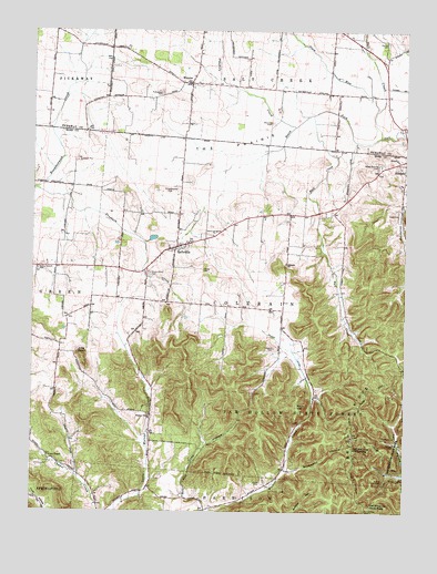
Hallsville, OH USGS Topographic Map
Click on map above to begin viewing in our Map Viewer.

This topographic map contains these locations and features:
Feature Name Type Latitude Longitude GNIS ID View Map
Beech ForkStreamN39.4723°W82.7588°1037790View Map
Brush RidgeRidgeN39.3978°W82.7674°1038405View Map
Brush Ridge Lookout TowerTowerN39.3751°W82.7629°1080023View Map
Bull CreekStreamN39.4784°W82.7810°1038510View Map
Coey HollowValleyN39.3798°W82.8235°1039221View Map
Colerain ChurchChurchN39.4395°W82.7904°1039251View Map
Colerain Township Fire DepartmentBuildingN39.4440°W82.8269°2549636View Map
Dresbach CreekStreamN39.4587°W82.8743°1039787View Map
Green Summit CemeteryCemeteryN39.4648°W82.7585°1041113View Map
HallsvillePopulated PlaceN39.4440°W82.8271°1064778View Map
Hallsville Post OfficePost OfficeN39.4445°W82.8277°2056626View Map
Hickle CemeteryCemeteryN39.4382°W82.8195°1041518View Map
Jobs KnobSummitN39.4151°W82.8585°1048874View Map
Jones CemeteryCemeteryN39.3826°W82.7982°1042137View Map
Leasure CemeteryCemeteryN39.4176°W82.7943°1042453View Map
Maple Grove CemeteryCemeteryN39.4370°W82.8363°1042937View Map
Mission FieldAirportN39.4295°W82.8219°1082729View Map
Monnett CemeteryCemeteryN39.4759°W82.7966°1043437View Map
Oakgrove School (historical)SchoolN39.4959°W82.8493°1050129View Map
Pikehole CreekStreamN39.4756°W82.7871°1044444View Map
Pleasant Valley Church (historical)ChurchN39.4009°W82.8343°1050000View Map
Plum RunStreamN39.4795°W82.7604°1044648View Map
Prairieview CemeteryCemeteryN39.4837°W82.8322°1044752View Map
Rock HillSummitN39.4026°W82.7857°1049129View Map
Salem Reform CemeteryCemeteryN39.4378°W82.8730°1045900View Map
Salem Reformed ChurchChurchN39.4381°W82.8732°1963446View Map
Saltcreek - Tarlton Volunteer Fire Department Station 2BuildingN39.4885°W82.8206°2549054View Map
Slickaway HollowValleyN39.3859°W82.7888°1046346View Map
Stumpf CemeteryCemeteryN39.4970°W82.7566°1046784View Map
Swamp DitchCanalN39.4220°W82.7971°1046888View Map
Swamp School (historical)SchoolN39.4087°W82.7813°1050001View Map
The PrairieFlatN39.4701°W82.8113°1047010View Map
Throckmorton CemeteryCemeteryN39.4579°W82.8295°1047051View Map
Township of ColerainCivilN39.4274°W82.7997°1086892View Map
Union ChapelChurchN39.3895°W82.8691°1047302View Map
Union Chapel CemeteryCemeteryN39.3895°W82.8691°1963448View Map
Walnut Valley ChurchChurchN39.4001°W82.8352°1047544View Map
WhislerPopulated PlaceN39.4867°W82.8199°1061772View Map
Whisler Post Office (historical)Post OfficeN39.4862°W82.8193°2042447View Map

Note: Coordinates in the location and feature list above are referenced to NAD83 datum.


Copyright (C) 2008-2024 Ryan Niemi / Sunset Dynamics ... All Rights Reserved