TopoQuest Logo
Do you find TopoQuest useful?
Help keep TopoQuest running and adding new maps/features by donating!
Bitcoin:  19c7KJd3qBynnjoSw5npx9KScwjBe4ifkT
Litecoin:  LXs6TkuXGGXo1vDsWCkWVdjQX94eUKd6ui
Home View Maps Find Maps Find Places Resources & Links


Kingston, Ohio Topographic Map

USGS Map Title: Kingston, OH
USGS Map MRC: 39082D8
DRG (GeoTIFF) Download: o39082d8.tif


Neighboring USGS Topographic Map Quads:


  Williamsport, OH  
39083E1
 

  Circleville, OH  
39082E8
 

  Stoutsville, OH  
39082E7
 

  Andersonville, OH  
39083D1
 

  Kingston, OH  
39082D8
 

  Hallsville, OH  
39082D7
 

  Chillicothe West, OH  
39083C1
 

  Chillicothe East, OH  
39082C8
 

  Londonderry, OH  
39082C7


Map MRC Location:

N40°
W83°
N40°
W82°
H8 H7 H6 H5 H4 H3 H2 H1
G8 G7 G6 G5 G4 G3 G2 G1
F8 F7 F6 F5 F4 F3 F2 F1
E8 E7 E6 E5 E4 E3 E2 E1
D8 D7 D6 D5 D4 D3 D2 D1
C8 C7 C6 C5 C4 C3 C2 C1
B8 B7 B6 B5 B4 B3 B2 B1
A8 A7 A6 A5 A4 A3 A2 A1
N39°
W83°
N39°
W82°

Kingston, OH USGS 1:24K Topographic Map Preview:
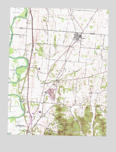
Kingston, OH USGS Topographic Map
Click on map above to begin viewing in our Map Viewer.

This topographic map contains these locations and features:
Feature Name Type Latitude Longitude GNIS ID View Map
Adena Regional Medical CenterHospitalN39.3960°W82.9690°2548866View Map
Bald HillSummitN39.3926°W82.9341°1037589View Map
Bethel CemeteryCemeteryN39.4173°W82.8957°1963437View Map
Bethel ChapelChurchN39.4173°W82.8955°1037918View Map
Blackwater CreekStreamN39.4509°W82.9816°1038095View Map
Bunker HillSummitN39.3751°W82.9471°1048567View Map
Camp DavellaLocaleN39.3795°W82.9463°1038691View Map
Centralia SchoolSchoolN39.4278°W82.9382°1038969View Map
Courtright (historical)Populated PlaceN39.4484°W82.9274°1049999View Map
Crouse ChapelChurchN39.4398°W82.9635°1039499View Map
Crouse Chapel CemeteryCemeteryN39.4398°W82.9630°1963439View Map
DelanoPopulated PlaceN39.4070°W82.9555°1062728View Map
Green Township Fire DepartmentBuildingN39.4744°W82.9103°2549643View Map
Green Township Fire Department Station 2BuildingN39.4068°W82.9654°2549116View Map
Hays HillSummitN39.4020°W82.9002°1048828View Map
HopetownPopulated PlaceN39.3787°W82.9752°1064862View Map
Hopetown CemeteryCemeteryN39.3773°W82.9713°1963440View Map
Hopetown Post Office (historical)Post OfficeN39.3792°W82.9749°2056651View Map
KingstonPopulated PlaceN39.4740°W82.9107°1064942View Map
Kingston ChurchChurchN39.4642°W82.8816°1042288View Map
Kingston Post OfficePost OfficeN39.4737°W82.9110°2056667View Map
KinnikinnickPopulated PlaceN39.4259°W82.9527°1058188View Map
Kinnikinnick CreekStreamN39.4412°W82.9791°1080498View Map
Kinnikinnick Post Office (historical)Post OfficeN39.4265°W82.9527°2056654View Map
Medical Center Hospital HeliportAirportN39.3956°W82.9693°1082568View Map
MetzgerPopulated PlaceN39.3937°W82.9557°1048969View Map
Miller CemeteryCemeteryN39.4112°W82.8888°1043350View Map
Mount Pleasant Presbyterian CemeteryCemeteryN39.4626°W82.9299°1963442View Map
Ohio State Highway Patrol - Chillicothe Patrol PostBuildingN39.3946°W82.9706°2733130View Map
Overly ChapelChurchN39.3815°W82.9488°1044247View Map
Overly Chapel CemeteryCemeteryN39.3815°W82.9488°1963443View Map
Sabre FarmsLocaleN39.4867°W82.9742°2725796View Map
Sand HillSummitN39.3851°W82.9268°1049152View Map
South Fork Kinnikinnick CreekStreamN39.4456°W82.8966°1046464View Map
Springfield Township Volunteer Fire Department Station 3BuildingN39.3840°W82.9530°2549086View Map
SugarloafSummitN39.4006°W82.9349°1066995View Map
Township of GreenCivilN39.4349°W82.9235°1086896View Map
Village of KingstonCivilN39.4723°W82.9120°2398352View Map
Wesley ChapelChurchN39.3778°W82.9730°1047692View Map
WFCB-FM (Chillicothe)TowerN39.4048°W82.9718°1085329View Map
Zane Trace Middle SchoolSchoolN39.4737°W82.9107°1058571View Map

Note: Coordinates in the location and feature list above are referenced to NAD83 datum.


Copyright (C) 2008-2025 Ryan Niemi / Sunset Dynamics ... All Rights Reserved