TopoQuest Logo
Do you find TopoQuest useful?
Help keep TopoQuest running and adding new maps/features by donating!
Bitcoin:  19c7KJd3qBynnjoSw5npx9KScwjBe4ifkT
Litecoin:  LXs6TkuXGGXo1vDsWCkWVdjQX94eUKd6ui
Home View Maps Find Maps Find Places Resources & Links


Hammett, Pennsylvania Topographic Map

USGS Map Title: Hammett, PA
USGS Map MRC: 42079A8
DRG (GeoTIFF) Download: o42079a8.tif


Neighboring USGS Topographic Map Quads:


  Erie North, PA  
42080B1
 

  Harborcreek, PA  
42079B8
 

  North East, PA  
42079B7
 

  Erie South, PA  
42080A1
 

  Hammett, PA  
42079A8
 

  Wattsburg, PA  
42079A7
 

  Cambridge Springs NE, PA  
41080H1
 

  Waterford, PA  
41079H8
 

  Union City, PA  
41079H7


Map MRC Location:

N43°
W80°
N43°
W79°
H8 H7 H6 H5 H4 H3 H2 H1
G8 G7 G6 G5 G4 G3 G2 G1
F8 F7 F6 F5 F4 F3 F2 F1
E8 E7 E6 E5 E4 E3 E2 E1
D8 D7 D6 D5 D4 D3 D2 D1
C8 C7 C6 C5 C4 C3 C2 C1
B8 B7 B6 B5 B4 B3 B2 B1
A8 A7 A6 A5 A4 A3 A2 A1
N42°
W80°
N42°
W79°

Hammett, PA USGS 1:24K Topographic Map Preview:
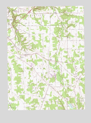
Hammett, PA USGS Topographic Map
Click on map above to begin viewing in our Map Viewer.

This topographic map contains these locations and features:
Feature Name Type Latitude Longitude GNIS ID View Map
Bogus CornersPopulated PlaceN42.0601°W79.9312°1169943View Map
Brumagins FarmsLocaleN42.0231°W79.8917°2712271View Map
East Greene ChurchChurchN42.0873°W79.9020°1173815View Map
EmergyCare Greene TownshipBuildingN42.0746°W79.9840°2719678View Map
Freedom FarmsLocaleN42.0456°W79.9931°2711779View Map
Green Summit FarmLocaleN42.0167°W79.9867°2711777View Map
Hack's Hog FarmLocaleN42.1161°W79.9119°2711778View Map
HammettPopulated PlaceN42.0667°W79.9687°1176438View Map
Intergreen Gorge CemeteryCemeteryN42.1089°W79.9956°1177824View Map
KuhlPopulated PlaceN42.0920°W79.9639°1178700View Map
Kuhl Hose Company Barton Road StationBuildingN42.0316°W79.9329°2645366View Map
Kuhl Hose Company Station 68BuildingN42.0746°W79.9841°2645591View Map
Kuhl Hose Company Station 69BuildingN42.0913°W79.9646°2645377View Map
Kuhl Road SpeedwayLocaleN42.1039°W79.9701°1213255View Map
Lake PleasantLakeN42.0042°W79.8978°1184097View Map
Lake Pleasant CornersLocaleN42.0123°W79.9037°1205261View Map
Mount of Olives CemeteryCemeteryN42.0650°W79.9713°1181649View Map
Owens CornersPopulated PlaceN42.1162°W79.9198°1183150View Map
Penn State Erie (Behrend) Census Designated PlaceCensusN42.1185°W79.9818°2633746View Map
Pennsylvania State University Behrend CollegeSchoolN42.1194°W79.9839°1169133View Map
PhillipsvillePopulated PlaceN42.0367°W79.8848°1183680View Map
Phillipsville CemeteryCemeteryN42.0288°W79.9010°1183681View Map
Prince of Peace Lutheran ChurchChurchN42.0626°W79.9795°1184416View Map
Ro - Max FarmsLocaleN42.0222°W79.9906°2711786View Map
Runway FarmsLocaleN42.0269°W79.9356°2711827View Map
Saint Boniface SchoolSchoolN42.0667°W79.9706°1185841View Map
Saint Peters ChurchChurchN42.0917°W79.9645°1186683View Map
SampsonPopulated PlaceN42.0092°W79.9976°1204579View Map
Siegel Marsh DamDamN42.0534°W79.9314°1195883View Map
Siegel Marsh ReservoirReservoirN42.0534°W79.9314°1195882View Map
State Game Lands Number 161ParkN42.0028°W79.9159°1188461View Map
State Game Lands Number 218ParkN42.0445°W79.9187°1188493View Map
Telview Dairy FarmLocaleN42.0603°W79.9983°2711775View Map
Township of GreeneCivilN42.0516°W79.9545°1216414View Map
Wattsburg Hose Company Station 18BuildingN42.0354°W79.8830°2645381View Map
WCCK-FM (Erie)TowerN42.0903°W79.9434°1200330View Map
Weeds CornersPopulated PlaceN42.0301°W79.9331°1190769View Map
West GreenePopulated PlaceN42.0142°W79.9406°1191032View Map
West Greene ChurchChurchN42.0187°W79.9381°1191033View Map
Wintergreen Gorge CemeteryCemeteryN42.1116°W79.9998°1191612View Map
Yaple CornersLocaleN42.0026°W79.9423°1205262View Map

Note: Coordinates in the location and feature list above are referenced to NAD83 datum.


Copyright (C) 2008-2025 Ryan Niemi / Sunset Dynamics ... All Rights Reserved