TopoQuest Logo
Do you find TopoQuest useful?
Help keep TopoQuest running and adding new maps/features by donating!
Bitcoin:  19c7KJd3qBynnjoSw5npx9KScwjBe4ifkT
Litecoin:  LXs6TkuXGGXo1vDsWCkWVdjQX94eUKd6ui
Home View Maps Find Maps Find Places Resources & Links


Hanleyville, Missouri Topographic Map

USGS Map Title: Hanleyville, MO
USGS Map MRC: 36090F3
DRG (GeoTIFF) Download: o36090f3.tif


Neighboring USGS Topographic Map Quads:


  Poplar Bluff, MO  
36090G4
 

  Rombauer, MO  
36090G3
 

  Fisk, MO  
36090G2
 

  Harviell, MO  
36090F4
 

  Hanleyville, MO  
36090F3
 

  Broseley, MO  
36090F2
 

  Vastus, MO  
36090E4
 

  Oglesville, MO  
36090E3
 

  Glennonville, MO  
36090E2


Map MRC Location:

N37°
W91°
N37°
W90°
H8 H7 H6 H5 H4 H3 H2 H1
G8 G7 G6 G5 G4 G3 G2 G1
F8 F7 F6 F5 F4 F3 F2 F1
E8 E7 E6 E5 E4 E3 E2 E1
D8 D7 D6 D5 D4 D3 D2 D1
C8 C7 C6 C5 C4 C3 C2 C1
B8 B7 B6 B5 B4 B3 B2 B1
A8 A7 A6 A5 A4 A3 A2 A1
N36°
W91°
N36°
W90°

Hanleyville, MO USGS 1:24K Topographic Map Preview:
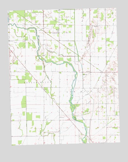
Hanleyville, MO USGS Topographic Map
Click on map above to begin viewing in our Map Viewer.

This topographic map contains these locations and features:
Feature Name Type Latitude Longitude GNIS ID View Map
Ackerman DitchCanalN36.6303°W90.3590°713130View Map
Ascraft Church (historical)ChurchN36.6920°W90.3748°746847View Map
Ash HillsRangeN36.6681°W90.2765°713420View Map
Ashcraft CemeteryCemeteryN36.6895°W90.3734°713427View Map
Ashcraft School (historical)SchoolN36.6909°W90.3748°746846View Map
Bethlehem Temple ChurchChurchN36.7309°W90.3157°714113View Map
Big IslandIslandN36.6481°W90.3182°739587View Map
Big Island Church (historical)ChurchN36.6495°W90.3193°746848View Map
Big Island SchoolSchoolN36.6501°W90.3179°714184View Map
Black River ChurchChurchN36.6909°W90.2820°714308View Map
Blue Spring SloughStreamN36.6853°W90.2901°748940View Map
Brown Field Airport (historical)AirportN36.7052°W90.2678°2679408View Map
Buttermilk BendBendN36.6698°W90.3034°739583View Map
Caledonia HillsRangeN36.7264°W90.2798°715192View Map
Caledonia School (historical)SchoolN36.7345°W90.2762°735303View Map
Caney SloughGutN36.7428°W90.3254°749196View Map
Catherine SloughStreamN36.7059°W90.2948°715498View Map
Church of GodChurchN36.7401°W90.3154°715837View Map
Colvin School (historical)SchoolN36.6334°W90.2648°746851View Map
Cross SloughStreamN36.6517°W90.3045°735305View Map
Deadmans BendBendN36.6684°W90.3051°739584View Map
Ditch Number 14CanalN36.6551°W90.2520°755060View Map
Doolens PastureFlatN36.6401°W90.3057°735304View Map
Giles ChurchChurchN36.7289°W90.3157°718441View Map
Grape Vine BendBendN36.6987°W90.3037°739580View Map
Hammons BendBendN36.7162°W90.3393°739578View Map
HanleyvillePopulated PlaceN36.6887°W90.2901°740903View Map
Hargove BridgeBridgeN36.6470°W90.3001°755201View Map
Hayes FieldAirportN36.7166°W90.3145°758875View Map
Hillis CemeteryCemeteryN36.6545°W90.2879°719618View Map
Hoggs EddyRapidsN36.7009°W90.3121°739579View Map
Jackson BarBarN36.7370°W90.3743°739577View Map
KWOC-AM (Poplar Bluff)TowerN36.7209°W90.3679°754261View Map
KWOC-FM (Poplar Bluff)TowerN36.7217°W90.3696°759067View Map
Lake SloughStreamN36.6576°W90.3007°720756View Map
Landreth ChurchChurchN36.7339°W90.2751°720790View Map
Liberty ChurchChurchN36.6764°W90.3348°720967View Map
Liberty SchoolSchoolN36.6931°W90.3357°746845View Map
Live Oak SchoolSchoolN36.7220°W90.3740°721364View Map
Lone Beach SchoolSchoolN36.6617°W90.2734°746850View Map
Marshall EddyRapidsN36.6884°W90.2990°739582View Map
MayberryPopulated PlaceN36.6901°W90.2548°739581View Map
Morning Star ChurchChurchN36.7306°W90.3337°722626View Map
MoroccoPopulated PlaceN36.7367°W90.3601°735302View Map
Morocco CemeteryCemeteryN36.7362°W90.3459°722632View Map
Morocco School (historical)SchoolN36.7295°W90.3343°735301View Map
Panther Run SloughGutN36.7370°W90.2532°751488View Map
Providence ChurchChurchN36.7484°W90.3162°742665View Map
Providence SchoolSchoolN36.7489°W90.3148°724975View Map
Stillcamp School (historical)SchoolN36.6481°W90.3654°746849View Map
Tabernacle of Charity ChurchChurchN36.7278°W90.3165°727429View Map

Note: Coordinates in the location and feature list above are referenced to NAD83 datum.


Copyright (C) 2008-2025 Ryan Niemi / Sunset Dynamics ... All Rights Reserved