TopoQuest Logo
Do you find TopoQuest useful?
Help keep TopoQuest running and adding new maps/features by donating!
Bitcoin:  19c7KJd3qBynnjoSw5npx9KScwjBe4ifkT
Litecoin:  LXs6TkuXGGXo1vDsWCkWVdjQX94eUKd6ui
Home View Maps Find Maps Find Places Resources & Links


Oglesville, Missouri Topographic Map

USGS Map Title: Oglesville, MO
USGS Map MRC: 36090E3
DRG (GeoTIFF) Download: o36090e3.tif


Neighboring USGS Topographic Map Quads:


  Harviell, MO  
36090F4
 

  Hanleyville, MO  
36090F3
 

  Broseley, MO  
36090F2
 

  Vastus, MO  
36090E4
 

  Oglesville, MO  
36090E3
 

  Glennonville, MO  
36090E2
 

  McDougal, AR  
36090D4
 

  Pollard, AR  
36090D3
 

  Piggott, AR  
36090D2


Map MRC Location:

N37°
W91°
N37°
W90°
H8 H7 H6 H5 H4 H3 H2 H1
G8 G7 G6 G5 G4 G3 G2 G1
F8 F7 F6 F5 F4 F3 F2 F1
E8 E7 E6 E5 E4 E3 E2 E1
D8 D7 D6 D5 D4 D3 D2 D1
C8 C7 C6 C5 C4 C3 C2 C1
B8 B7 B6 B5 B4 B3 B2 B1
A8 A7 A6 A5 A4 A3 A2 A1
N36°
W91°
N36°
W90°

Oglesville, MO USGS 1:24K Topographic Map Preview:
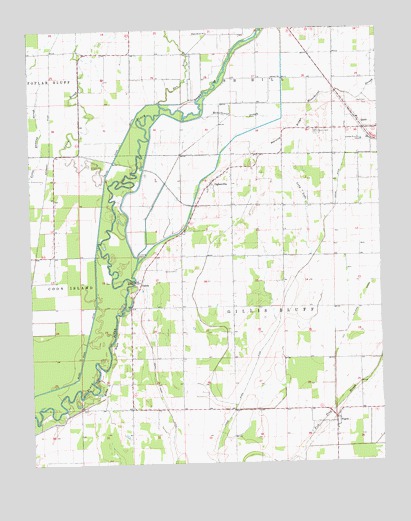
Oglesville, MO USGS Topographic Map
Click on map above to begin viewing in our Map Viewer.

This topographic map contains these locations and features:
Feature Name Type Latitude Longitude GNIS ID View Map
Big Elm EddyRapidsN36.5951°W90.3332°739593View Map
Black River DitchCanalN36.5362°W90.3554°714309View Map
Buffalo Hole BendBendN36.5206°W90.3523°739589View Map
Cache River DitchCanalN36.5420°W90.2865°715175View Map
Caliph Pearl BendBendN36.5120°W90.3737°739590View Map
Calvary ChurchChurchN36.6106°W90.2882°715215View Map
Caney SloughStreamN36.5831°W90.3479°715362View Map
CarolaPopulated PlaceN36.5517°W90.3358°740723View Map
Carola CemeteryCemeteryN36.5556°W90.3234°715412View Map
Carola School (historical)SchoolN36.5359°W90.3445°746856View Map
City of QulinCivilN36.5948°W90.2535°2396303View Map
Dan RiverStreamN36.6042°W90.3284°735574View Map
Devils ElbowBendN36.5676°W90.3459°739588View Map
Duck Roost CutoffChannelN36.6037°W90.3187°739592View Map
Duschs Store (historical)BuildingN36.5314°W90.3393°735312View Map
FagusPopulated PlaceN36.5114°W90.2670°735609View Map
Fagus School (historical)SchoolN36.5048°W90.2754°735311View Map
Gillis BluffCliffN36.5281°W90.3470°718455View Map
Gillis Bluff School (historical)SchoolN36.5592°W90.3207°746859View Map
Kelly CemeteryCemeteryN36.6037°W90.2573°720512View Map
Long LakeSwampN36.5777°W90.2781°721550View Map
Melville RidgeRidgeN36.5945°W90.2818°722213View Map
Melville School (historical)SchoolN36.5881°W90.2932°746858View Map
Menorkenut Slough Number 16StreamN36.6001°W90.3132°755315View Map
OglesvillePopulated PlaceN36.5803°W90.3104°723705View Map
Platanus (historical)Populated PlaceN36.5345°W90.2645°739595View Map
Qulin CemeteryCemeteryN36.5951°W90.2723°725028View Map
Qulin Fire Protection DepartmentBuildingN36.5964°W90.2503°2621712View Map
Qulin Post OfficePost OfficeN36.5955°W90.2527°2782937View Map
Qulin SchoolSchoolN36.5962°W90.2790°746857View Map
Shotgun BendBendN36.6095°W90.3084°739591View Map
Swan Pond (historical)LakeN36.5420°W90.3332°735310View Map
Swan Pond DitchCanalN36.5170°W90.3284°727362View Map
Township of Gillis BluffCivilN36.5423°W90.2811°766354View Map
WhitlowPopulated PlaceN36.5753°W90.3145°739594View Map
Whitlow Census Designated PlaceCensusN36.5790°W90.3096°2587122View Map

Note: Coordinates in the location and feature list above are referenced to NAD83 datum.


Copyright (C) 2008-2024 Ryan Niemi / Sunset Dynamics ... All Rights Reserved