TopoQuest Logo
Do you find TopoQuest useful?
Help keep TopoQuest running and adding new maps/features by donating!
Bitcoin:  19c7KJd3qBynnjoSw5npx9KScwjBe4ifkT
Litecoin:  LXs6TkuXGGXo1vDsWCkWVdjQX94eUKd6ui
Home View Maps Find Maps Find Places Resources & Links


Springfield, South Carolina Topographic Map

USGS Map Title: Springfield, SC
USGS Map MRC: 33081D3
DRG (GeoTIFF) Download: o33081d3.tif


Neighboring USGS Topographic Map Quads:


  Kitchings Mill, SC  
33081E4
 

  Salley, SC  
33081E3
 

  Harleys Millpond, SC  
33081E2
 

  Williston, SC  
33081D4
 

  Springfield, SC  
33081D3
 

  Norway West, SC  
33081D2
 

  Long Branch, SC  
33081C4
 

  Blackville, SC  
33081C3
 

  Denmark, SC  
33081C2


Map MRC Location:

N34°
W82°
N34°
W81°
H8 H7 H6 H5 H4 H3 H2 H1
G8 G7 G6 G5 G4 G3 G2 G1
F8 F7 F6 F5 F4 F3 F2 F1
E8 E7 E6 E5 E4 E3 E2 E1
D8 D7 D6 D5 D4 D3 D2 D1
C8 C7 C6 C5 C4 C3 C2 C1
B8 B7 B6 B5 B4 B3 B2 B1
A8 A7 A6 A5 A4 A3 A2 A1
N33°
W82°
N33°
W81°

Springfield, SC USGS 1:24K Topographic Map Preview:
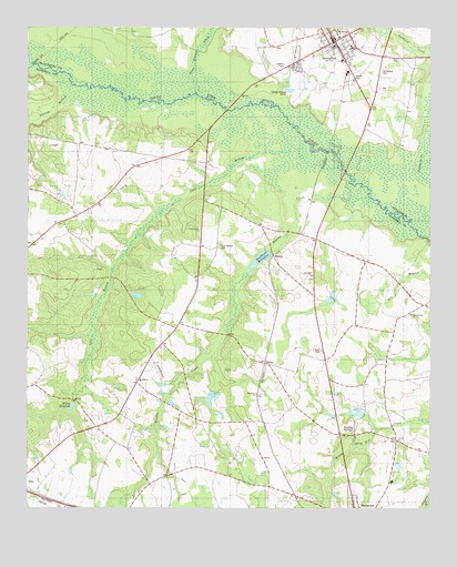
Springfield, SC USGS Topographic Map
Click on map above to begin viewing in our Map Viewer.

This topographic map contains these locations and features:
Feature Name Type Latitude Longitude GNIS ID View Map
Bolens Pond D-3055 DamDamN33.4068°W81.3148°1239725View Map
Boylston Mill (historical)LocaleN33.4349°W81.3484°1235435View Map
Brodie Family CemeteryCemeteryN33.4968°W81.2759°2681190View Map
Calvary ChurchChurchN33.3924°W81.2598°1247097View Map
Calvary School (historical)SchoolN33.4079°W81.3407°1235446View Map
Dean Swamp CreekStreamN33.4829°W81.3218°1247511View Map
Dry Branch School (historical)SchoolN33.4254°W81.2562°1235458View Map
Ebenezer Baptist ChurchChurchN33.4049°W81.3037°1247612View Map
Ebenezer School (historical)SchoolN33.4043°W81.3040°1235462View Map
Foster Branch Church (historical)ChurchN33.4435°W81.3157°1235474View Map
Frost Branch Baptist ChurchChurchN33.4476°W81.3212°1247847View Map
Frost Branch CemeteryCemeteryN33.4435°W81.3151°1222598View Map
Frost Branch School (historical)SchoolN33.4435°W81.3145°1235479View Map
Healing Spring School (historical)SchoolN33.3946°W81.2751°1235492View Map
Healing SpringsPopulated PlaceN33.3940°W81.2734°1245933View Map
Healing SpringsSpringN33.3918°W81.2732°1235493View Map
Healing Springs Baptist ChurchChurchN33.3938°W81.2732°1235494View Map
Matthews Mill Pond D-3049 DamDamN33.4418°W81.3001°1239739View Map
Matthews MillpondReservoirN33.4397°W81.3028°1246561View Map
Mount Calvary ChurchChurchN33.4088°W81.3407°1224687View Map
Pilgrim Rest Baptist ChurchChurchN33.4257°W81.2557°1250089View Map
Pine Hill ChurchChurchN33.4357°W81.2862°1225453View Map
Redds Pond D-3050 DamDamN33.4285°W81.2798°1239745View Map
Reese Creek School (historical)SchoolN33.4482°W81.3048°1235527View Map
Saint Matthews School (historical)SchoolN33.4182°W81.3332°1235535View Map
Saint Stephens ChurchChurchN33.4993°W81.2787°1226273View Map
SpringfieldPopulated PlaceN33.4968°W81.2793°1226837View Map
Springfield CemeteryCemeteryN33.4890°W81.2651°1226838View Map
Springfield Elementary SchoolSchoolN33.4949°W81.2745°1242861View Map
Springfield Fire DepartmentBuildingN33.4975°W81.2748°2578206View Map
Springfield Post OfficePost OfficeN33.4967°W81.2800°2489893View Map
Spur BranchStreamN33.4707°W81.2887°1251019View Map
Stills Pond D-3057 DamDamN33.4002°W81.2698°1239752View Map
Town of SpringfieldCivilN33.4967°W81.2795°2407388View Map
W C Smiths Pond D-3070 DamDamN33.4218°W81.3748°1239753View Map
WalkerPopulated PlaceN33.4129°W81.3012°1251310View Map
WhaleyPopulated PlaceN33.4410°W81.2984°1231910View Map
Whaley CreekStreamN33.4557°W81.2679°1251402View Map
Willis Mill (historical)LocaleN33.4029°W81.3598°1235572View Map
Willis Mill Pond D-3054 DamDamN33.4026°W81.3601°1239754View Map
Willis MillpondReservoirN33.4015°W81.3608°1251456View Map
Williston Fire DepartmentBuildingN33.4503°W81.3612°2737335View Map
Yarrow BranchStreamN33.4826°W81.3623°1227725View Map
Yaw Branch School (historical)SchoolN33.4526°W81.3568°1235568View Map

Note: Coordinates in the location and feature list above are referenced to NAD83 datum.


Copyright (C) 2008-2025 Ryan Niemi / Sunset Dynamics ... All Rights Reserved