TopoQuest Logo
Do you find TopoQuest useful?
Help keep TopoQuest running and adding new maps/features by donating!
Bitcoin:  19c7KJd3qBynnjoSw5npx9KScwjBe4ifkT
Litecoin:  LXs6TkuXGGXo1vDsWCkWVdjQX94eUKd6ui
Home View Maps Find Maps Find Places Resources & Links


Norway West, South Carolina Topographic Map

USGS Map Title: Norway West, SC
USGS Map MRC: 33081D2
DRG (GeoTIFF) Download: o33081d2.tif


Neighboring USGS Topographic Map Quads:


  Salley, SC  
33081E3
 

  Harleys Millpond, SC  
33081E2
 

  North, SC  
33081E1
 

  Springfield, SC  
33081D3
 

  Norway West, SC  
33081D2
 

  Norway East, SC  
33081D1
 

  Blackville, SC  
33081C3
 

  Denmark, SC  
33081C2
 

  Bamberg, SC  
33081C1


Map MRC Location:

N34°
W82°
N34°
W81°
H8 H7 H6 H5 H4 H3 H2 H1
G8 G7 G6 G5 G4 G3 G2 G1
F8 F7 F6 F5 F4 F3 F2 F1
E8 E7 E6 E5 E4 E3 E2 E1
D8 D7 D6 D5 D4 D3 D2 D1
C8 C7 C6 C5 C4 C3 C2 C1
B8 B7 B6 B5 B4 B3 B2 B1
A8 A7 A6 A5 A4 A3 A2 A1
N33°
W82°
N33°
W81°

Norway West, SC USGS 1:24K Topographic Map Preview:
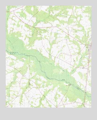
Norway West, SC USGS Topographic Map
Click on map above to begin viewing in our Map Viewer.

This topographic map contains these locations and features:
Feature Name Type Latitude Longitude GNIS ID View Map
Bull BranchStreamN33.4352°W81.1848°1242539View Map
Bushy Pond ChurchChurchN33.4585°W81.1612°1247073View Map
Campbell BranchStreamN33.4890°W81.1865°1221274View Map
Campbell Branch School (historical)SchoolN33.4843°W81.1826°1242551View Map
Cedar Grove ChurchChurchN33.4185°W81.1282°1221453View Map
Collums Pond D-3071 DamDamN33.3768°W81.2498°1239727View Map
Cowford LakeSwampN33.4178°W81.1920°1242588View Map
Creco (historical)Populated PlaceN33.4221°W81.1295°1242590View Map
Dry BranchStreamN33.4360°W81.2307°1222104View Map
Duncans Bridge (historical)BridgeN33.4107°W81.1879°1242883View Map
Edisto ClubPopulated PlaceN33.4029°W81.1562°1231261View Map
Good Will School (historical)SchoolN33.4935°W81.2215°1242640View Map
Goodland CreekStreamN33.4432°W81.2332°1222761View Map
Hairs Pond D-3060 DamDamN33.3885°W81.2448°1239732View Map
Holman Bridge (historical)BridgeN33.4043°W81.1551°1230934View Map
Hunter-Kinard-Tyler High SchoolSchoolN33.4463°W81.1287°1242665View Map
Jericho CemeteryCemeteryN33.3821°W81.1493°1223550View Map
Jericho ChurchChurchN33.3815°W81.1498°1230938View Map
Jericho School (historical)SchoolN33.3815°W81.1498°1230939View Map
Kittrell LandingLocaleN33.3888°W81.1307°1230943View Map
Little Ponderosa Lake Dam D-3748DamN33.4568°W81.1265°1240337View Map
Little RiverStreamN33.4146°W81.1576°1224030View Map
Martin CemeteryCemeteryN33.4863°W81.2287°1246543View Map
Morgan Family CemeteryCemeteryN33.4863°W81.2287°2681222View Map
Nicks Lake (historical)LakeN33.4399°W81.2365°1252200View Map
NorwayPopulated PlaceN33.4518°W81.1254°1249902View Map
Norway CemeteryCemeteryN33.4532°W81.1382°1225090View Map
Norway Fire DepartmentBuildingN33.4526°W81.1370°2578177View Map
Norway Post OfficePost OfficeN33.4509°W81.1256°2489867View Map
Oak Ridge School (historical)SchoolN33.4996°W81.1518°1242740View Map
Oakland School (historical)SchoolN33.3807°W81.1820°1230962View Map
Pardees Pond Dam D-3747DamN33.4635°W81.1332°1240336View Map
Pleasant BranchStreamN33.4715°W81.2076°1225527View Map
Pleasant Branch ChurchChurchN33.4679°W81.2029°1225528View Map
Pleasant Branch School (historical)SchoolN33.4677°W81.2026°1242778View Map
Rocky Swamp CreekStreamN33.4454°W81.2193°1250456View Map
Rocky Swamp School (historical)SchoolN33.4746°W81.1873°1242810View Map
Rogers BranchStreamN33.4179°W81.2023°1225992View Map
Sheepford BranchStreamN33.3985°W81.2448°1226551View Map
Slaughter FieldAreaN33.4021°W81.2468°1235553View Map
Snake BranchStreamN33.4057°W81.1718°1226717View Map
South Carolina Noname 38068 D-3764 DamDamN33.4368°W81.1298°1238173View Map
Sunshine Baptist ChurchChurchN33.4143°W81.2234°1251079View Map
Sunshine School (historical)SchoolN33.4046°W81.2287°1235557View Map
Sunshine School (historical)SchoolN33.4085°W81.2165°1235558View Map
SwedenPopulated PlaceN33.3790°W81.1351°1231849View Map
Sykes SwampStreamN33.3865°W81.1359°1251100View Map
Tampa CreekStreamN33.4932°W81.2454°1251117View Map
Town of NorwayCivilN33.4503°W81.1266°2407010View Map
Tylers LandingLocaleN33.3940°W81.1348°1242880View Map
Waynor (historical)Populated PlaceN33.4099°W81.1320°1242906View Map
West Willow School (historical)SchoolN33.4371°W81.1790°1242907View Map
Willow Swamp Baptist ChurchChurchN33.4240°W81.1368°1251461View Map
Willow Swamp Baptist Church CemeteryCemeteryN33.4249°W81.1373°2681250View Map
Windy Hill CreekStreamN33.4371°W81.2195°1227651View Map
Youngs IslandIslandN33.4196°W81.1812°1242905View Map

Note: Coordinates in the location and feature list above are referenced to NAD83 datum.


Copyright (C) 2008-2025 Ryan Niemi / Sunset Dynamics ... All Rights Reserved