TopoQuest Logo
Do you find TopoQuest useful?
Help keep TopoQuest running and adding new maps/features by donating!
Bitcoin:  19c7KJd3qBynnjoSw5npx9KScwjBe4ifkT
Litecoin:  LXs6TkuXGGXo1vDsWCkWVdjQX94eUKd6ui
Home View Maps Find Maps Find Places Resources & Links


Harman, West Virginia Topographic Map

USGS Map Title: Harman, WV
USGS Map MRC: 38079H5
DRG (GeoTIFF) Download: o38079h5.tif


Neighboring USGS Topographic Map Quads:


  Parsons, WV  
39079A6
 

  Mozark Mountain, WV  
39079A5
 

  Blackwater Falls, WV  
39079A4
 

  Bowden, WV  
38079H6
 

  Harman, WV  
38079H5
 

  Laneville, WV  
38079H4
 

  Glady, WV  
38079G6
 

  Whitmer, WV  
38079G5
 

  Onego, WV  
38079G4


Map MRC Location:

N39°
W80°
N39°
W79°
H8 H7 H6 H5 H4 H3 H2 H1
G8 G7 G6 G5 G4 G3 G2 G1
F8 F7 F6 F5 F4 F3 F2 F1
E8 E7 E6 E5 E4 E3 E2 E1
D8 D7 D6 D5 D4 D3 D2 D1
C8 C7 C6 C5 C4 C3 C2 C1
B8 B7 B6 B5 B4 B3 B2 B1
A8 A7 A6 A5 A4 A3 A2 A1
N38°
W80°
N38°
W79°

Harman, WV USGS 1:24K Topographic Map Preview:
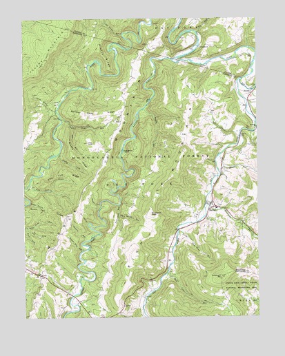
Harman, WV USGS Topographic Map
Click on map above to begin viewing in our Map Viewer.

This topographic map contains these locations and features:
Feature Name Type Latitude Longitude GNIS ID View Map
Ash LickStreamN38.9123°W79.6228°1550119View Map
Baker HollowValleyN38.9226°W79.6212°1550152View Map
Beech Pen RidgeRidgeN38.9193°W79.6117°1550247View Map
Big RunStreamN38.9943°W79.5320°1550333View Map
Big SpringSpringN38.9168°W79.5345°1677671View Map
Big Spring RunStreamN38.9182°W79.5742°1550349View Map
Birch LickStreamN38.9129°W79.6248°1550361View Map
Brierpatch MountainSummitN38.8918°W79.5198°1550459View Map
Brushheap KnobSummitN38.9182°W79.5570°1554002View Map
Brushy CreekStreamN38.9434°W79.6064°1550501View Map
Brushy RidgeRidgeN38.9426°W79.5981°1550515View Map
Coon Bone IslandIslandN38.9448°W79.5717°1550784View Map
Coopers RunStreamN38.9079°W79.5889°1550791View Map
Cunningham SpringSpringN38.9112°W79.5734°1677676View Map
Dr Bucher SpringSpringN38.9246°W79.5256°1677669View Map
Dry HollowValleyN38.9146°W79.5914°1550966View Map
DryforkPopulated PlaceN38.9687°W79.5028°1554331View Map
Five Lick CreekStreamN38.9307°W79.6217°1551121View Map
Five Lick RidgeRidgeN38.9354°W79.6034°1551122View Map
Flannigan School (historical)SchoolN38.8979°W79.6223°1727076View Map
George Tyson Farm SpringSpringN38.8918°W79.5512°1677677View Map
HarmanPopulated PlaceN38.9223°W79.5251°1551361View Map
Harman Church of the BrethrenChurchN38.9143°W79.5095°1727081View Map
Harman Post OfficePost OfficeN38.9224°W79.5242°1727082View Map
Harman SchoolSchoolN38.9206°W79.5222°1727083View Map
Harman Volunteer Fire DepartmentBuildingN38.9209°W79.5251°2577732View Map
Hazelwood (historical)Populated PlaceN38.8946°W79.5478°1727086View Map
Herman Smith SpringSpringN38.8762°W79.5609°1677668View Map
Hog KnobSummitN38.9482°W79.5909°1551463View Map
Hog RunStreamN38.9551°W79.5989°1551465View Map
Horsecamp RunStreamN38.9218°W79.5278°1551501View Map
Jasper Yokum Farm SpringsSpringN38.9209°W79.5164°1677667View Map
JenningstonPopulated PlaceN38.9882°W79.5306°1554803View Map
Job RunStreamN38.8804°W79.5978°1551581View Map
John Mullennex SpringSpringN38.8848°W79.5601°1677666View Map
Johnson School (historical)SchoolN38.9818°W79.5162°1727043View Map
Kerns CemeteryCemeteryN38.9401°W79.5823°1551640View Map
Krafts RidgeRidgeN38.9840°W79.5812°1551670View Map
Kuntzville (historical)Populated PlaceN38.9804°W79.5906°1727091View Map
Laurel ForkStreamN38.9826°W79.5453°1551712View Map
Little Tory Camp RunStreamN38.9109°W79.5423°1551900View Map
Mylius School (historical)SchoolN38.9479°W79.6212°1727101View Map
Panther Camp RidgeRidgeN38.9587°W79.5873°1552416View Map
Panther Camp RunStreamN38.9590°W79.6053°1552417View Map
Pennington School (historical)SchoolN38.9434°W79.5084°1727105View Map
Perlytown (historical)Populated PlaceN38.9829°W79.5545°1727106View Map
Pershing Harman Farm SpringSpringN38.8959°W79.5456°1677678View Map
Pershing Harman Farm SpringSpringN38.9098°W79.5414°1677679View Map
Pioneer Memorial Public LibraryBuildingN38.9206°W79.5214°2727373View Map
Randolph County Emergency Squad Station 3BuildingN38.9209°W79.5251°2581131View Map
Red CreekStreamN38.9746°W79.5078°1552601View Map
Red Creek Junction (historical)LocaleN38.9704°W79.5109°1727109View Map
Rich Mountain School (historical)SchoolN38.9601°W79.5256°1727110View Map
Riverside ChurchChurchN38.9543°W79.5001°1552675View Map
Shears HollowValleyN38.9223°W79.5845°1552857View Map
Snyder RunStreamN38.9623°W79.5603°1552958View Map
Spruce RunStreamN38.9365°W79.5209°1553030View Map
Suck Lick RunStreamN38.9221°W79.5742°1553107View Map
SullyPopulated PlaceN38.9571°W79.5728°1555741View Map
Taylor Elza RunStreamN38.9029°W79.5931°1553181View Map
Three Spring RunStreamN38.9654°W79.6042°1553230View Map
Tory Camp RunStreamN38.8932°W79.5481°1553251View Map
Town of HarmanCivilN38.9211°W79.5246°2390231View Map
Two Spring RunStreamN38.9934°W79.5720°1553303View Map
White CemeteryCemeteryN38.8843°W79.6181°1553621View Map
WymerPopulated PlaceN38.8934°W79.6187°1553527View Map
Wymer Post OfficePost OfficeN38.8934°W79.6167°1727124View Map
Yankee SpringSpringN38.8946°W79.5803°1677681View Map

Note: Coordinates in the location and feature list above are referenced to NAD83 datum.


Copyright (C) 2008-2025 Ryan Niemi / Sunset Dynamics ... All Rights Reserved