TopoQuest Logo
Do you find TopoQuest useful?
Help keep TopoQuest running and adding new maps/features by donating!
Bitcoin:  19c7KJd3qBynnjoSw5npx9KScwjBe4ifkT
Litecoin:  LXs6TkuXGGXo1vDsWCkWVdjQX94eUKd6ui
Home View Maps Find Maps Find Places Resources & Links


Blackwater Falls, West Virginia Topographic Map

USGS Map Title: Blackwater Falls, WV
USGS Map MRC: 39079A4
DRG (GeoTIFF) Download: o39079a4.tif


Neighboring USGS Topographic Map Quads:


  Lead Mine, WV  
39079B5
 

  Davis, WV  
39079B4
 

  Mount Storm Lake, WV  
39079B3
 

  Mozark Mountain, WV  
39079A5
 

  Blackwater Falls, WV  
39079A4
 

  Blackbird Knob, WV  
39079A3
 

  Harman, WV  
38079H5
 

  Laneville, WV  
38079H4
 

  Hopeville, WV  
38079H3


Map MRC Location:

N40°
W80°
N40°
W79°
H8 H7 H6 H5 H4 H3 H2 H1
G8 G7 G6 G5 G4 G3 G2 G1
F8 F7 F6 F5 F4 F3 F2 F1
E8 E7 E6 E5 E4 E3 E2 E1
D8 D7 D6 D5 D4 D3 D2 D1
C8 C7 C6 C5 C4 C3 C2 C1
B8 B7 B6 B5 B4 B3 B2 B1
A8 A7 A6 A5 A4 A3 A2 A1
N39°
W80°
N39°
W79°

Blackwater Falls, WV USGS 1:24K Topographic Map Preview:
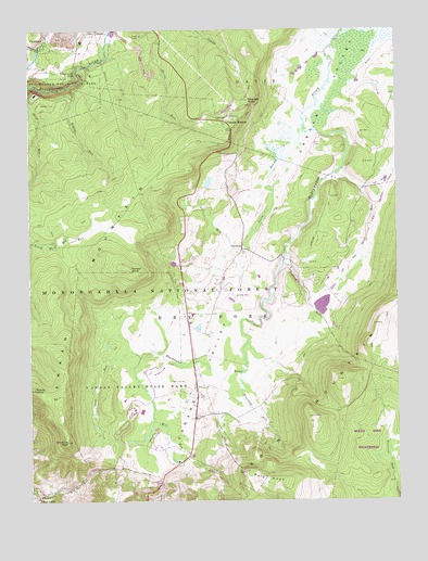
Blackwater Falls, WV USGS Topographic Map
Click on map above to begin viewing in our Map Viewer.

This topographic map contains these locations and features:
Feature Name Type Latitude Longitude GNIS ID View Map
Bald KnobSummitN39.0051°W79.4192°1553788View Map
Bearden KnobSummitN39.1054°W79.4259°1550202View Map
Blackwater FallsFallsN39.1138°W79.4832°1550380View Map
Blackwater Falls State ParkParkN39.1121°W79.4953°1550381View Map
Blackwater LodgeBuildingN39.1082°W79.4976°1689311View Map
Buena (historical)Populated PlaceN39.0132°W79.4456°1689316View Map
Cabin MountainSummitN39.0048°W79.4189°1554044View Map
Canaan HeightsPopulated PlaceN39.0982°W79.4306°1550625View Map
Canaan MountainSummitN39.0301°W79.4984°1550626View Map
Canaan Valley National Wildlife RefugeParkN39.1015°W79.3889°2043595View Map
Canaan Valley National Wildlife RefugeParkN39.0984°W79.3890°2025226View Map
Canaan Valley Resort State ParkParkN39.0273°W79.4620°1550628View Map
Canaan Valley Resorts Golf CourseLocaleN39.0317°W79.4523°2634009View Map
Canaan Valley Volunteer Fire DepartmentBuildingN39.0496°W79.4471°2577942View Map
Chimney RockSummitN39.0159°W79.4876°1550704View Map
Club RunStreamN39.0393°W79.4639°1550733View Map
Cooper KnobSummitN39.0618°W79.4656°1554186View Map
CortlandPopulated PlaceN39.0671°W79.4275°1550795View Map
Cortland CemeteryCemeteryN39.0582°W79.4359°1689330View Map
Cortland Grade School (historical)SchoolN39.0557°W79.4353°1689331View Map
Cosner School (historical)SchoolN39.0276°W79.4434°1689333View Map
Devils Run SpringSpringN39.1084°W79.4526°1677828View Map
Dry Fork DistrictCivilN39.0329°W79.4608°1928254View Map
Dunkenbarger TrailTrailN39.0012°W79.3795°1553665View Map
East Branch Weimer RunStreamN39.1239°W79.4425°2631354View Map
Engine RunStreamN39.1101°W79.4856°1551061View Map
Flanagan Hill ChurchChurchN39.0015°W79.4967°1689349View Map
Flat RidgeSummitN39.0023°W79.4670°1555382View Map
Flat RunStreamN39.0671°W79.4303°1551135View Map
Flat Run Lake DamDamN39.0834°W79.4448°1559317View Map
Freeland RunStreamN39.0329°W79.4289°1551179View Map
Graham Farm SpringSpringN39.0251°W79.4206°1677827View Map
Harmon School (historical)SchoolN39.0409°W79.4039°1689358View Map
Harr School (historical)SchoolN39.0048°W79.4556°1689360View Map
Lee Huffman SpringSpringN39.0007°W79.4584°1677826View Map
Maple Grove School (historical)SchoolN39.0804°W79.4309°1689382View Map
Mill RunStreamN39.0382°W79.4623°1552127View Map
North Branch Blackwater RiverStreamN39.0979°W79.4067°1552315View Map
Pendleton Run Watershed DamDamN39.1168°W79.4998°1559312View Map
Pointy KnobSummitN39.0301°W79.4987°1552526View Map
Red CreekPopulated PlaceN39.0009°W79.4973°1552599View Map
Red Creek Post OfficePost OfficeN39.0017°W79.4989°1689400View Map
Sand RunStreamN39.0882°W79.3928°1552790View Map
Shays RunStreamN39.1101°W79.4995°1552856View Map
Spruce Island LakeReservoirN39.0601°W79.3914°1559316View Map
Spruce Island Lake DamDamN39.0601°W79.3914°1559315View Map
Stonecoal TrailTrailN39.0098°W79.3767°1553071View Map
Tucker County Emergency Medical Services SubstationBuildingN39.0495°W79.4470°2581133View Map
West Branch Weimer RunStreamN39.1239°W79.4425°2631355View Map
Windwood Fly-In Resort AirportAirportN39.0559°W79.4299°2443474View Map
Yoakum RunStreamN39.0632°W79.4134°1553536View Map

Note: Coordinates in the location and feature list above are referenced to NAD83 datum.


Copyright (C) 2008-2024 Ryan Niemi / Sunset Dynamics ... All Rights Reserved