TopoQuest Logo
Do you find TopoQuest useful?
Help keep TopoQuest running and adding new maps/features by donating!
Bitcoin:  19c7KJd3qBynnjoSw5npx9KScwjBe4ifkT
Litecoin:  LXs6TkuXGGXo1vDsWCkWVdjQX94eUKd6ui
Home View Maps Find Maps Find Places Resources & Links


Whitmer, West Virginia Topographic Map

USGS Map Title: Whitmer, WV
USGS Map MRC: 38079G5
DRG (GeoTIFF) Download: o38079g5.tif


Neighboring USGS Topographic Map Quads:


  Bowden, WV  
38079H6
 

  Harman, WV  
38079H5
 

  Laneville, WV  
38079H4
 

  Glady, WV  
38079G6
 

  Whitmer, WV  
38079G5
 

  Onego, WV  
38079G4
 

  Sinks of Gandy, WV  
38079F6
 

  Spruce Knob, WV  
38079F5
 

  Circleville, WV  
38079F4


Map MRC Location:

N39°
W80°
N39°
W79°
H8 H7 H6 H5 H4 H3 H2 H1
G8 G7 G6 G5 G4 G3 G2 G1
F8 F7 F6 F5 F4 F3 F2 F1
E8 E7 E6 E5 E4 E3 E2 E1
D8 D7 D6 D5 D4 D3 D2 D1
C8 C7 C6 C5 C4 C3 C2 C1
B8 B7 B6 B5 B4 B3 B2 B1
A8 A7 A6 A5 A4 A3 A2 A1
N38°
W80°
N38°
W79°

Whitmer, WV USGS 1:24K Topographic Map Preview:
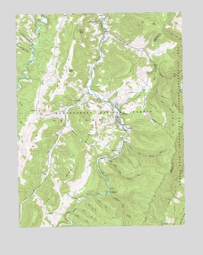
Whitmer, WV USGS Topographic Map
Click on map above to begin viewing in our Map Viewer.

This topographic map contains these locations and features:
Feature Name Type Latitude Longitude GNIS ID View Map
Allegheny TrailTrailN38.8040°W79.5123°1550092View Map
Bear Hunter TrailTrailN38.7573°W79.5237°1553642View Map
Bee RunStreamN38.7668°W79.5742°1550240View Map
Bee TrailTrailN38.7582°W79.5670°1550243View Map
Bennett RunStreamN38.8262°W79.6248°1550262View Map
Bethel ChurchChurchN38.8737°W79.5592°1550270View Map
Burnt Ridge RunStreamN38.8546°W79.6123°1550568View Map
Dry Fork DistrictCivilN38.8497°W79.6109°1928253View Map
Dry Fork School (historical)SchoolN38.8218°W79.5831°1727149View Map
Elza RunStreamN38.7612°W79.5823°1551058View Map
Elza TrailTrailN38.7540°W79.5759°1551059View Map
Falls RunStreamN38.7679°W79.5659°1551097View Map
GandyPopulated PlaceN38.8271°W79.5698°1551200View Map
Gandy CreekStreamN38.8304°W79.5692°1551201View Map
Gregg KnobSummitN38.8409°W79.5853°1551303View Map
Haines KnobSummitN38.8648°W79.5776°1551320View Map
Horse RockSummitN38.7532°W79.5006°1551497View Map
HortonPopulated PlaceN38.8073°W79.5426°1554746View Map
Horton TrailTrailN38.7640°W79.5078°1551410View Map
JobPopulated PlaceN38.8643°W79.5570°1551576View Map
Job KnobSummitN38.8682°W79.5226°1551578View Map
Judy Springs CampgroundLocaleN38.7512°W79.5173°1551617View Map
Judy Springs TrailTrailN38.7526°W79.5126°1553643View Map
Lambert ChurchChurchN38.8598°W79.6126°1551686View Map
Lambert HollowValleyN38.8587°W79.6134°1551688View Map
Lambert School (historical)SchoolN38.8618°W79.6092°1727175View Map
Laurel Hill CemeteryCemeteryN38.8207°W79.5498°1551716View Map
Lee Bennett HollowValleyN38.7507°W79.5898°1551762View Map
Little Allegheny TrailTrailN38.8184°W79.5053°1551827View Map
Little ItalyPopulated PlaceN38.7943°W79.5492°1554964View Map
Little Low PlaceGapN38.7968°W79.5709°1551873View Map
Low PlaceGapN38.7576°W79.6037°1551955View Map
Lower Two Spring RunStreamN38.7996°W79.5451°1551964View Map
Lumberjack TrailTrailN38.7557°W79.5042°1553021View Map
Mary Elza SpringSpringN38.8079°W79.5534°1677717View Map
Mullenax RunStreamN38.8101°W79.5887°1552263View Map
Ray Mullennex SpringSpringN38.8259°W79.5751°1677720View Map
Rich MountainRidgeN38.8315°W79.5934°1552646View Map
Sallys Cabin SpringSpringN38.8418°W79.6039°1677722View Map
Smith RunStreamN38.8421°W79.5189°1552941View Map
Snyder SpringSpringN38.8501°W79.5998°1677724View Map
Spring RidgeRidgeN38.7840°W79.5278°1553641View Map
Stinking RunStreamN38.8640°W79.5578°1553061View Map
Swallow Rock CampgroundLocaleN38.7701°W79.5556°1553152View Map
Swallow Rock RunStreamN38.7698°W79.5567°1553153View Map
Swallow Rock TrailTrailN38.7543°W79.5406°1553154View Map
Taylor RunStreamN38.7651°W79.5781°1553184View Map
Upper Gulf RunStreamN38.8371°W79.5145°1553324View Map
Upper Two Spring RunStreamN38.7884°W79.5559°1553330View Map
White (historical)Populated PlaceN38.7654°W79.5792°1727227View Map
WhitmerPopulated PlaceN38.8129°W79.5489°1553440View Map
Whitmer Census Designated PlaceCensusN38.8149°W79.5451°2586901View Map
Whitmer Volunteer Fire DepartmentBuildingN38.8161°W79.5497°2577598View Map
William Armentrout SpringSpringN38.8551°W79.5939°1677723View Map

Note: Coordinates in the location and feature list above are referenced to NAD83 datum.


Copyright (C) 2008-2025 Ryan Niemi / Sunset Dynamics ... All Rights Reserved