TopoQuest Logo
Do you find TopoQuest useful?
Help keep TopoQuest running and adding new maps/features by donating!
Bitcoin:  19c7KJd3qBynnjoSw5npx9KScwjBe4ifkT
Litecoin:  LXs6TkuXGGXo1vDsWCkWVdjQX94eUKd6ui
Home View Maps Find Maps Find Places Resources & Links


Harmony Grove, Arkansas Topographic Map

USGS Map Title: Harmony Grove, AR
USGS Map MRC: 33092F7
DRG (GeoTIFF) Download: o33092f7.tif


Neighboring USGS Topographic Map Quads:


  Tates Bluff, AR  
33092G8
 

  Ouachita, AR  
33092G7
 

  Holly Springs, AR  
33092G6
 

  Bragg City, AR  
33092F8
 

  Harmony Grove, AR  
33092F7
 

  Eagle Mills, AR  
33092F6
 

  Camden SW, AR  
33092E8
 

  Camden, AR  
33092E7
 

  East Camden, AR  
33092E6


Map MRC Location:

N34°
W93°
N34°
W92°
H8 H7 H6 H5 H4 H3 H2 H1
G8 G7 G6 G5 G4 G3 G2 G1
F8 F7 F6 F5 F4 F3 F2 F1
E8 E7 E6 E5 E4 E3 E2 E1
D8 D7 D6 D5 D4 D3 D2 D1
C8 C7 C6 C5 C4 C3 C2 C1
B8 B7 B6 B5 B4 B3 B2 B1
A8 A7 A6 A5 A4 A3 A2 A1
N33°
W93°
N33°
W92°

Harmony Grove, AR USGS 1:24K Topographic Map Preview:
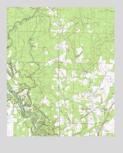
Harmony Grove, AR USGS Topographic Map
Click on map above to begin viewing in our Map Viewer.

This topographic map contains these locations and features:
Feature Name Type Latitude Longitude GNIS ID View Map
AmyPopulated PlaceN33.7321°W92.8154°45859View Map
Bear BranchStreamN33.7443°W92.7718°46201View Map
Bethel TempleChurchN33.6640°W92.7749°46463View Map
Big Dixon LakeLakeN33.7196°W92.8471°74662View Map
Broughton CemeteryCemeteryN33.6707°W92.7677°46984View Map
Burks PondLakeN33.6511°W92.7650°74720View Map
CamarkPopulated PlaceN33.6323°W92.7668°57495View Map
Chapel CreekStreamN33.6923°W92.7974°47694View Map
Dixon Lake SloughStreamN33.6907°W92.8379°48538View Map
Faith ChurchChurchN33.6826°W92.8046°48982View Map
Fishers LakeLakeN33.6262°W92.8275°74834View Map
Freeo CreekStreamN33.6543°W92.8566°76975View Map
Harmony GrovePopulated PlaceN33.6521°W92.7810°49873View Map
Harmony Grove CemeteryCemeteryN33.6670°W92.7740°49874View Map
Harmony Grove Elementary SchoolSchoolN33.6516°W92.7803°64389View Map
Harmony Grove High SchoolSchoolN33.6514°W92.7796°64390View Map
Kemp (historical)Populated PlaceN33.7376°W92.8210°64393View Map
KentPopulated PlaceN33.6257°W92.8132°58014View Map
Little Dixon LakeLakeN33.7129°W92.8471°74955View Map
Lower Old RiverLakeN33.6346°W92.8360°75007View Map
Martin CemeteryCemeteryN33.6676°W92.7768°51701View Map
Ouachita County Volunteer Fire Department Fire District 1 Amy Station 5BuildingN33.7155°W92.8068°2116910View Map
Ouachita County Volunteer Fire Department Fire District 1 Harmony Grove Station 1BuildingN33.6533°W92.7774°2116911View Map
Ouachita County Volunteer Fire Department Fire District 1 Pine Lake Station 3BuildingN33.6455°W92.8173°2116914View Map
Pine LakeLakeN33.6472°W92.8332°75077View Map
Rumph CemeteryCemeteryN33.7004°W92.7928°54265View Map
Saint Mary ChurchChurchN33.6968°W92.8113°54408View Map
Saint Paul CemeteryCemeteryN33.6726°W92.7782°54433View Map
Saint Paul ChurchChurchN33.6768°W92.7791°54440View Map
Shady Grove Baptist ChurchChurchN33.6401°W92.7604°78321View Map
Toney CemeteryCemeteryN33.6990°W92.8241°55605View Map
Toney Old RiverLakeN33.6942°W92.8701°75174View Map
Township of CarrollCivilN33.7477°W92.8306°68914View Map
Township of ValleyCivilN33.6786°W92.7729°68926View Map
Union Grove Community CenterLocaleN33.6612°W92.8079°55819View Map
VanduzerPopulated PlaceN33.6518°W92.7732°58793View Map
VeliePopulated PlaceN33.6996°W92.8204°58799View Map
Velie Church of God in ChristChurchN33.6746°W92.8060°78653View Map
WarnerPopulated PlaceN33.6382°W92.7977°57231View Map

Note: Coordinates in the location and feature list above are referenced to NAD83 datum.


Copyright (C) 2008-2024 Ryan Niemi / Sunset Dynamics ... All Rights Reserved