TopoQuest Logo
Do you find TopoQuest useful?
Help keep TopoQuest running and adding new maps/features by donating!
Bitcoin:  19c7KJd3qBynnjoSw5npx9KScwjBe4ifkT
Litecoin:  LXs6TkuXGGXo1vDsWCkWVdjQX94eUKd6ui
Home View Maps Find Maps Find Places Resources & Links


Harriet, Arkansas Topographic Map

USGS Map Title: Harriet, AR
USGS Map MRC: 35092H5
DRG (GeoTIFF) Download: o35092h5.tif


Neighboring USGS Topographic Map Quads:


  Maumee, AR  
36092A6
 

  Cozahome, AR  
36092A5
 

  Big Flat, AR  
36092A4
 

  Marshall, AR  
35092H6
 

  Harriet, AR  
35092H5
 

  Landis, AR  
35092H4
 

  Canaan, AR  
35092G6
 

  Leslie, AR  
35092G5
 

  Oxley, AR  
35092G4


Map MRC Location:

N36°
W93°
N36°
W92°
H8 H7 H6 H5 H4 H3 H2 H1
G8 G7 G6 G5 G4 G3 G2 G1
F8 F7 F6 F5 F4 F3 F2 F1
E8 E7 E6 E5 E4 E3 E2 E1
D8 D7 D6 D5 D4 D3 D2 D1
C8 C7 C6 C5 C4 C3 C2 C1
B8 B7 B6 B5 B4 B3 B2 B1
A8 A7 A6 A5 A4 A3 A2 A1
N35°
W93°
N35°
W92°

Harriet, AR USGS 1:24K Topographic Map Preview:
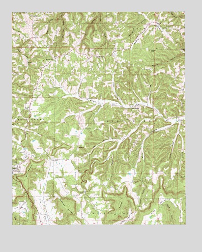
Harriet, AR USGS Topographic Map
Click on map above to begin viewing in our Map Viewer.

This topographic map contains these locations and features:
Feature Name Type Latitude Longitude GNIS ID View Map
BakerPopulated PlaceN35.9137°W92.5977°46024View Map
Barr MountainSummitN35.8879°W92.5468°46117View Map
Barren HollowPopulated PlaceN35.9454°W92.5538°69953View Map
Barren HollowValleyN35.9400°W92.5189°46122View Map
Barren Hollow ChurchChurchN35.9456°W92.5524°46123View Map
Begley (historical)Populated PlaceN35.8856°W92.5338°69954View Map
Big HollowValleyN35.9242°W92.5471°46564View Map
Big HollowValleyN35.9459°W92.5263°46565View Map
Blackjack KnobSummitN35.9771°W92.5244°57387View Map
Cartwright HollowValleyN35.9963°W92.5281°47500View Map
Cypert CemeteryCemeteryN35.9456°W92.5588°48286View Map
Davis CreekStreamN35.9390°W92.5182°48391View Map
Devils BackboneRidgeN35.9065°W92.6141°48486View Map
East Lawn CemeteryCemeteryN35.9173°W92.6143°48769View Map
Grand View ChurchChurchN35.9856°W92.6199°49547View Map
Grassy HollowValleyN35.9442°W92.5427°49571View Map
Gray HollowValleyN35.9179°W92.5532°49613View Map
HarrietPopulated PlaceN35.9934°W92.5204°77126View Map
Harriet Post OfficePost OfficeN35.9941°W92.5204°84510View Map
Kimball BranchStreamN35.9967°W92.5904°77402View Map
Lone PinePopulated PlaceN35.9731°W92.5627°51400View Map
Martin BoxPopulated PlaceN35.9426°W92.6124°69970View Map
Martin Box ChapelChurchN35.9431°W92.6138°51699View Map
Mears HollowValleyN35.9354°W92.5084°51892View Map
Mill HollowValleyN35.9973°W92.5627°52037View Map
Morning StarPopulated PlaceN35.9729°W92.5941°52197View Map
Morning Star Baptist ChurchChurchN35.9717°W92.5963°69971View Map
Morning Star Fire DepartmentBuildingN35.9694°W92.5986°2116809View Map
Red Hill CemeteryCemeteryN35.9315°W92.5727°53948View Map
Red Hill ChurchChurchN35.9204°W92.5774°53950View Map
Reed HollowValleyN35.9353°W92.5041°53970View Map
Rock SpringsPopulated PlaceN35.9448°W92.5354°78199View Map
Sanders CemeteryCemeteryN35.8813°W92.6135°54553View Map
Shilo (historical)Populated PlaceN35.9031°W92.5279°69973View Map
Shiloh CemeteryCemeteryN35.9048°W92.5246°54777View Map
Shiloh ChurchChurchN35.9015°W92.5291°54798View Map
Shiloh HollowValleyN35.8994°W92.5308°54801View Map
Stephenson MountainSummitN35.8865°W92.5854°58686View Map
The WildernessAreaN35.9642°W92.5374°69981View Map
Township of Bear Creek Number 6CivilN35.9027°W92.6077°2406940View Map
Township of Big Creek (historical)CivilN35.9417°W92.5404°69082View Map
Watts CemeteryCemeteryN35.8926°W92.5660°56117View Map
Whaley HollowValleyN35.9284°W92.5054°56217View Map
Wilson CemeteryCemeteryN35.9201°W92.6077°56436View Map

Note: Coordinates in the location and feature list above are referenced to NAD83 datum.


Copyright (C) 2008-2024 Ryan Niemi / Sunset Dynamics ... All Rights Reserved