TopoQuest Logo
Do you find TopoQuest useful?
Help keep TopoQuest running and adding new maps/features by donating!
Bitcoin:  19c7KJd3qBynnjoSw5npx9KScwjBe4ifkT
Litecoin:  LXs6TkuXGGXo1vDsWCkWVdjQX94eUKd6ui
Home View Maps Find Maps Find Places Resources & Links


Canaan, Arkansas Topographic Map

USGS Map Title: Canaan, AR
USGS Map MRC: 35092G6
DRG (GeoTIFF) Download: o35092g6.tif


Neighboring USGS Topographic Map Quads:


  Snowball, AR  
35092H7
 

  Marshall, AR  
35092H6
 

  Harriet, AR  
35092H5
 

  Witts Springs, AR  
35092G7
 

  Canaan, AR  
35092G6
 

  Leslie, AR  
35092G5
 

  Tilly, AR  
35092F7
 

  Alread, AR  
35092F6
 

  Botkinburg, AR  
35092F5


Map MRC Location:

N36°
W93°
N36°
W92°
H8 H7 H6 H5 H4 H3 H2 H1
G8 G7 G6 G5 G4 G3 G2 G1
F8 F7 F6 F5 F4 F3 F2 F1
E8 E7 E6 E5 E4 E3 E2 E1
D8 D7 D6 D5 D4 D3 D2 D1
C8 C7 C6 C5 C4 C3 C2 C1
B8 B7 B6 B5 B4 B3 B2 B1
A8 A7 A6 A5 A4 A3 A2 A1
N35°
W93°
N35°
W92°

Canaan, AR USGS 1:24K Topographic Map Preview:
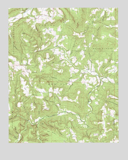
Canaan, AR USGS Topographic Map
Click on map above to begin viewing in our Map Viewer.

This topographic map contains these locations and features:
Feature Name Type Latitude Longitude GNIS ID View Map
Ballinger BranchStreamN35.8134°W92.6560°46066View Map
Barnes HollowValleyN35.7871°W92.6985°46107View Map
Bohannon MountainSummitN35.8156°W92.7143°46812View Map
Bradley HollowValleyN35.7753°W92.7399°70793View Map
Branch HollowValleyN35.7521°W92.7398°70795View Map
Brushy PointSummitN35.8517°W92.7341°57457View Map
Bryan HollowValleyN35.8748°W92.7266°47097View Map
Bunkhouse HollowValleyN35.7647°W92.7313°47185View Map
Butler HollowValleyN35.7717°W92.7279°47237View Map
CanaanPopulated PlaceN35.8670°W92.7035°76517View Map
Chimes - Shady Grove Volunteer Fire Department SubstationBuildingN35.7511°W92.6569°2116270View Map
Cotton HollowValleyN35.8613°W92.6432°48069View Map
Crooked BranchStreamN35.7698°W92.7263°48168View Map
Dean BranchStreamN35.8270°W92.6818°48430View Map
Dean MountainSummitN35.7598°W92.6979°57629View Map
Dean PointSummitN35.7676°W92.7102°57630View Map
Elmer HollowValleyN35.7777°W92.6927°48879View Map
Gower PointCliffN35.7648°W92.7243°49528View Map
Green Griffin KnobSummitN35.7924°W92.6377°57845View Map
Hilltop ChapelChurchN35.8565°W92.7071°50134View Map
Holstead HollowValleyN35.8715°W92.7294°50263View Map
KayPopulated PlaceN35.7862°W92.6921°57074View Map
King HollowValleyN35.8267°W92.6832°50855View Map
KSNE-FM (Marshall)TowerN35.8715°W92.6529°85224View Map
Little Red CreekStreamN35.8084°W92.6452°51312View Map
Mill CreekStreamN35.7720°W92.7127°52023View Map
Miller HollowValleyN35.7733°W92.7119°52065View Map
Mitchell HollowValleyN35.7586°W92.7359°52110View Map
Nolan HollowValleyN35.7722°W92.7087°52790View Map
Nolan PointCliffN35.7690°W92.7002°52792View Map
Oak Hill CemeteryCemeteryN35.8181°W92.7304°52925View Map
Oak Hill ChurchChurchN35.8229°W92.7299°52931View Map
Picayune HollowValleyN35.8179°W92.6671°53342View Map
Rambo ChurchChurchN35.8142°W92.6641°53887View Map
Rocky HollowValleyN35.8105°W92.6393°54143View Map
Schoolhouse BranchStreamN35.8162°W92.6618°54621View Map
Shady Grove CemeteryCemeteryN35.7578°W92.6479°54694View Map
Shady Grove ChurchChurchN35.7762°W92.6382°54718View Map
South MountainSummitN35.8484°W92.6660°58659View Map
South Mountain ChurchChurchN35.8748°W92.6407°55036View Map
South Mountain Fire DepartmentBuildingN35.8391°W92.6584°2117143View Map
Star MountainSummitN35.7959°W92.7257°58680View Map
Thompson CemeteryCemeteryN35.8162°W92.6543°55537View Map
Thompson PointSummitN35.7819°W92.7077°55548View Map
Township of Red RiverCivilN35.8150°W92.6692°69091View Map
Township of Shady GroveCivilN35.7526°W92.6775°69095View Map
Truck Wheel BranchStreamN35.7698°W92.6629°55666View Map
WattsPopulated PlaceN35.8184°W92.6593°58839View Map
Welcome Home Fire DepartmentBuildingN35.7858°W92.7487°2117286View Map

Note: Coordinates in the location and feature list above are referenced to NAD83 datum.


Copyright (C) 2008-2024 Ryan Niemi / Sunset Dynamics ... All Rights Reserved