TopoQuest Logo
Do you find TopoQuest useful?
Help keep TopoQuest running and adding new maps/features by donating!
Bitcoin:  19c7KJd3qBynnjoSw5npx9KScwjBe4ifkT
Litecoin:  LXs6TkuXGGXo1vDsWCkWVdjQX94eUKd6ui
Home View Maps Find Maps Find Places Resources & Links


Big Flat, Arkansas Topographic Map

USGS Map Title: Big Flat, AR
USGS Map MRC: 36092A4
DRG (GeoTIFF) Download: o36092a4.tif


Neighboring USGS Topographic Map Quads:


  Rea Valley, AR  
36092B5
 

  Buffalo City, AR  
36092B4
 

  Norfork, AR  
36092B3
 

  Cozahome, AR  
36092A5
 

  Big Flat, AR  
36092A4
 

  Norfork SE, AR  
36092A3
 

  Harriet, AR  
35092H5
 

  Landis, AR  
35092H4
 

  Onia, AR  
35092H3


Map MRC Location:

N37°
W93°
N37°
W92°
H8 H7 H6 H5 H4 H3 H2 H1
G8 G7 G6 G5 G4 G3 G2 G1
F8 F7 F6 F5 F4 F3 F2 F1
E8 E7 E6 E5 E4 E3 E2 E1
D8 D7 D6 D5 D4 D3 D2 D1
C8 C7 C6 C5 C4 C3 C2 C1
B8 B7 B6 B5 B4 B3 B2 B1
A8 A7 A6 A5 A4 A3 A2 A1
N36°
W93°
N36°
W92°

Big Flat, AR USGS 1:24K Topographic Map Preview:
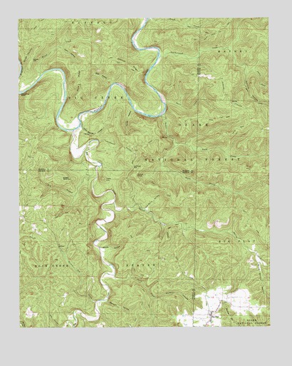
Big Flat, AR USGS Topographic Map
Click on map above to begin viewing in our Map Viewer.

This topographic map contains these locations and features:
Feature Name Type Latitude Longitude GNIS ID View Map
Almus KnobSummitN36.0616°W92.4431°70434View Map
Bear HollowValleyN36.0988°W92.4533°70566View Map
Big CreekStreamN36.0801°W92.4727°76335View Map
Big FlatPopulated PlaceN36.0051°W92.4043°76337View Map
Big Flat CemeteryCemeteryN36.0092°W92.4068°69345View Map
Big Flat Volunteer Fire DepartmentBuildingN36.0060°W92.4036°2116149View Map
Birch Minick HollowValleyN36.0270°W92.3804°70687View Map
Boonie FordCrossingN36.0801°W92.4765°70047View Map
Brush CreekStreamN36.1020°W92.4891°70852View Map
Bucker GapGapN36.1087°W92.4929°70901View Map
Canes ForkStreamN36.1040°W92.3835°70990View Map
Caney BranchStreamN36.0887°W92.4432°70051View Map
Caney HollowValleyN36.0889°W92.4440°71001View Map
Cap Berry HollowValleyN36.0481°W92.4367°71005View Map
Cold Spring HollowValleyN36.0803°W92.4688°71187View Map
Cozahome Post OfficePost OfficeN36.0490°W92.4977°84509View Map
Dark HollowValleyN36.1137°W92.4782°71337View Map
Dry BranchStreamN36.0620°W92.4610°71427View Map
Fishtrap CreekStreamN36.0948°W92.4993°70056View Map
Fishtrap ShoalBarN36.1012°W92.4771°70057View Map
Foster FordCrossingN36.1167°W92.4379°70058View Map
Fox Bar ShoalBarN36.1056°W92.4329°70059View Map
Greasy ShoalBarN36.0920°W92.4288°70062View Map
Hepsey (historical)Populated PlaceN36.0773°W92.4704°61029View Map
Horseshoe BendBendN36.0953°W92.4985°72083View Map
Huffman GapGapN36.0648°W92.4432°72112View Map
Leatherwood CreekStreamN36.1095°W92.4293°77463View Map
Leatherwood ShoalBarN36.1106°W92.4302°70065View Map
Leatherwood WildernessReserveN36.0909°W92.3867°74414View Map
Loonbeam HollowValleyN36.0753°W92.4599°72488View Map
Middle CreekStreamN36.0856°W92.4290°72635View Map
North Prong Middle CreekStreamN36.0742°W92.4207°72896View Map
Rocky FordCrossingN36.0809°W92.4707°70068View Map
Rose Berry ChuteChannelN36.0873°W92.4638°70069View Map
Rose RidgeRidgeN36.0998°W92.4699°73381View Map
Rough HollowValleyN36.1036°W92.4983°73392View Map
Sheep Jump CreekStreamN36.1162°W92.4435°70070View Map
Shields FordCrossingN36.1223°W92.4371°70072View Map
Short CreekStreamN36.0906°W92.4271°73566View Map
Short CreekStreamN36.0212°W92.4529°73567View Map
Slick Rock CreekStreamN36.0806°W92.4793°70074View Map
South Prong Middle CreekStreamN36.0745°W92.4207°78412View Map
Spencer FordCrossingN36.0981°W92.4352°70075View Map
Spencer HollowValleyN36.1024°W92.3865°73662View Map
Spencer RidgeRidgeN36.1089°W92.4530°73663View Map
Spring CreekStreamN36.0506°W92.4529°73673View Map
Suggs MountainSummitN36.0601°W92.4788°73765View Map
Tater HillSummitN36.0602°W92.4583°73832View Map
Town of Big FlatCivilN36.0056°W92.4066°2405261View Map
Township of Beaver (historical)CivilN36.0167°W92.4335°69081View Map
Township of Big Creek (historical)CivilN36.0917°W92.4613°69625View Map
Township of Rock CreekCivilN36.0238°W92.4979°69093View Map
Tri-County High SchoolSchoolN36.0023°W92.4052°69453View Map
Turkey Pen CreekStreamN36.0106°W92.4621°73908View Map
Vickery HollowValleyN36.0121°W92.4331°73968View Map
Warners FordCrossingN36.0903°W92.4779°70077View Map
Woodcocks FordCrossingN36.0926°W92.4452°70079View Map
Woodcocks Mill (historical)LocaleN36.0917°W92.4290°70080View Map
Woods HollowValleyN36.0308°W92.4590°74207View Map
Wooten FordCrossingN36.1003°W92.4902°70105View Map
Wooten HollowValleyN36.0104°W92.4569°74213View Map

Note: Coordinates in the location and feature list above are referenced to NAD83 datum.


Copyright (C) 2008-2024 Ryan Niemi / Sunset Dynamics ... All Rights Reserved