TopoQuest Logo
Do you find TopoQuest useful?
Help keep TopoQuest running and adding new maps/features by donating!
Bitcoin:  19c7KJd3qBynnjoSw5npx9KScwjBe4ifkT
Litecoin:  LXs6TkuXGGXo1vDsWCkWVdjQX94eUKd6ui
Home View Maps Find Maps Find Places Resources & Links


Cherry Valley East, Arkansas Topographic Map

USGS Map Title: Cherry Valley East, AR
USGS Map MRC: 35090D6
DRG (GeoTIFF) Download: o35090d6.tif


Neighboring USGS Topographic Map Quads:


  Powers Slough, AR  
35090E7
 

  Harrisburg, AR  
35090E6
 

  McCormick, AR  
35090E5
 

  Cherry Valley West, AR  
35090D7
 

  Cherry Valley East, AR  
35090D6
 

  Monterey, AR  
35090D5
 

  Vanndale, AR  
35090C7
 

  Princedale, AR  
35090C6
 

  Parkin, AR  
35090C5


Map MRC Location:

N36°
W91°
N36°
W90°
H8 H7 H6 H5 H4 H3 H2 H1
G8 G7 G6 G5 G4 G3 G2 G1
F8 F7 F6 F5 F4 F3 F2 F1
E8 E7 E6 E5 E4 E3 E2 E1
D8 D7 D6 D5 D4 D3 D2 D1
C8 C7 C6 C5 C4 C3 C2 C1
B8 B7 B6 B5 B4 B3 B2 B1
A8 A7 A6 A5 A4 A3 A2 A1
N35°
W91°
N35°
W90°

Cherry Valley East, AR USGS 1:24K Topographic Map Preview:
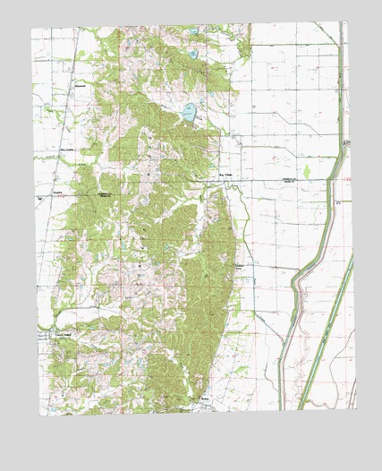
Cherry Valley East, AR USGS Topographic Map
Click on map above to begin viewing in our Map Viewer.

This topographic map contains these locations and features:
Feature Name Type Latitude Longitude GNIS ID View Map
Arkansas State Veterans Cemetery at BirdeyeCemeteryN35.3909°W90.6797°2775165View Map
Bay VillagePopulated PlaceN35.4498°W90.6759°76251View Map
Bay Village Volunteer Fire DepartmentBuildingN35.4449°W90.6746°2116117View Map
BirdeyePopulated PlaceN35.3787°W90.6873°76352View Map
Birdeye Post OfficePost OfficeN35.3759°W90.6854°82774View Map
Bowers CemeteryCemeteryN35.3984°W90.7423°46854View Map
Cherry Valley CreekStreamN35.4045°W90.7498°45738View Map
Coopey CreekStreamN35.4095°W90.7373°48018View Map
Distress CreekStreamN35.4934°W90.6632°48527View Map
Ditch Number 3CanalN35.4934°W90.6476°82201View Map
Ditch Number 4CanalN35.4567°W90.6465°82245View Map
Foust CreekStreamN35.4090°W90.7226°49208View Map
Halk CemeteryCemeteryN35.3929°W90.7396°49777View Map
Halk CreekStreamN35.4034°W90.7457°49778View Map
HydrickPopulated PlaceN35.4465°W90.7437°57964View Map
Labanon ChurchChurchN35.4717°W90.7384°50925View Map
Lebanon Baptist ChurchChurchN35.4717°W90.7393°65790View Map
Otter CreekStreamN35.4606°W90.6676°53082View Map
Pleasant Grove ChurchChurchN35.4748°W90.7476°53547View Map
Poinsett Watershed Site 1 DamDamN35.4751°W90.6818°81238View Map
Poinsett Watershed Site 101 DamDamN35.4717°W90.6901°81244View Map
Poinsett Watershed Site 101 ReservoirReservoirN35.4718°W90.6884°81245View Map
Poinsett Watershed Site 102 DamDamN35.4967°W90.6868°81246View Map
Poinsett Watershed Site 102 ReservoirReservoirN35.4980°W90.6858°81247View Map
Poinsett Watershed Site 2 DamDamN35.4884°W90.6851°81240View Map
Poinsett Watershed Site One ReservoirReservoirN35.4751°W90.6818°81239View Map
Poinsett Watershed Site Two ReservoirReservoirN35.4904°W90.6861°81241View Map
Riley CemeteryCemeteryN35.3895°W90.7446°54042View Map
Spring Hill CemeteryCemeteryN35.3773°W90.6934°55109View Map
Stark CemeteryCemeteryN35.4212°W90.7126°55165View Map
Straight SloughCanalN35.4126°W90.6473°55260View Map
Sugar CreekStreamN35.3962°W90.6529°55297View Map
Thomas ChurchChurchN35.4237°W90.7054°55527View Map
Thomas School (historical)SchoolN35.4234°W90.7048°82786View Map
Township of ColdwaterCivilN35.4014°W90.6299°79316View Map
Township of ScottCivilN35.4911°W90.7180°68980View Map
Tyer CemeteryCemeteryN35.4465°W90.7307°55772View Map
Valley View Baptist ChurchChurchN35.4812°W90.6457°78645View Map
Valley View School (historical)SchoolN35.4817°W90.6637°82766View Map
WhitehallPopulated PlaceN35.4804°W90.7357°78764View Map
Wiley CrossingPopulated PlaceN35.4606°W90.7401°58889View Map
Wiley Crossing Church (historical)ChurchN35.4606°W90.7415°82768View Map
Wiley Crossing School (historical)SchoolN35.4606°W90.7401°82769View Map

Note: Coordinates in the location and feature list above are referenced to NAD83 datum.


Copyright (C) 2008-2025 Ryan Niemi / Sunset Dynamics ... All Rights Reserved