TopoQuest Logo
Do you find TopoQuest useful?
Help keep TopoQuest running and adding new maps/features by donating!
Bitcoin:  19c7KJd3qBynnjoSw5npx9KScwjBe4ifkT
Litecoin:  LXs6TkuXGGXo1vDsWCkWVdjQX94eUKd6ui
Home View Maps Find Maps Find Places Resources & Links


Hartford, Kentucky Topographic Map

USGS Map Title: Hartford, KY
USGS Map MRC: 37086D8
DRG (GeoTIFF) Download: o37086d8.tif


Neighboring USGS Topographic Map Quads:


  Utica, KY  
37087E1
 

  Pleasant Ridge, KY  
37086E8
 

  Dundee, KY  
37086E7
 

  Equality, KY  
37087D1
 

  Hartford, KY  
37086D8
 

  Horton, KY  
37086D7
 

  Central City East, KY  
37087C1
 

  Paradise, KY  
37086C8
 

  Cromwell, KY  
37086C7


Map MRC Location:

N38°
W87°
N38°
W86°
H8 H7 H6 H5 H4 H3 H2 H1
G8 G7 G6 G5 G4 G3 G2 G1
F8 F7 F6 F5 F4 F3 F2 F1
E8 E7 E6 E5 E4 E3 E2 E1
D8 D7 D6 D5 D4 D3 D2 D1
C8 C7 C6 C5 C4 C3 C2 C1
B8 B7 B6 B5 B4 B3 B2 B1
A8 A7 A6 A5 A4 A3 A2 A1
N37°
W87°
N37°
W86°

Hartford, KY USGS 1:24K Topographic Map Preview:
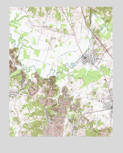
Hartford, KY USGS Topographic Map
Click on map above to begin viewing in our Map Viewer.

This topographic map contains these locations and features:
Feature Name Type Latitude Longitude GNIS ID View Map
Alexander CemeteryCemeteryN37.4834°W86.9236°485822View Map
Beaver DamPopulated PlaceN37.4020°W86.8758°486616View Map
Beaver Dam Fire DepartmentBuildingN37.4033°W86.8777°2636457View Map
Beaver Dam Police DepartmentBuildingN37.4033°W86.8778°2767479View Map
Bens LickStreamN37.4314°W86.9411°486874View Map
Big RunStreamN37.4375°W86.9789°487239View Map
Carson CemeteryCemeteryN37.4700°W86.9478°488986View Map
CentertownPopulated PlaceN37.4173°W86.9961°489277View Map
Central Grove ChurchChurchN37.4117°W86.9630°489285View Map
City of CentertownCivilN37.4178°W86.9960°2404022View Map
City of HartfordCivilN37.4505°W86.8930°2403810View Map
City of McHenryCivilN37.3794°W86.9226°2405050View Map
Fisher CemeteryCemeteryN37.3770°W86.9144°492113View Map
Goshen ChurchChurchN37.4109°W86.8994°493042View Map
Haiti CemeteryCemeteryN37.4545°W86.8947°493545View Map
HartfordPopulated PlaceN37.4512°W86.9092°493841View Map
Hartford Fire DepartmentBuildingN37.4515°W86.9039°2636646View Map
Hartford Police DepartmentBuildingN37.4504°W86.9075°2767482View Map
Hawkers BluffCliffN37.4875°W86.9019°493886View Map
Little No CreekStreamN37.4862°W86.9936°496818View Map
McCormick SloughGutN37.4675°W86.9822°497806View Map
McHenryPopulated PlaceN37.3820°W86.9225°497881View Map
McHenry Fire DepartmentBuildingN37.3817°W86.9221°2637059View Map
Midway CemeteryCemeteryN37.3925°W86.9567°498166View Map
Muddy CreekStreamN37.4378°W86.9297°499038View Map
No CreekPopulated PlaceN37.4806°W86.9583°508710View Map
North Fork Muddy CreekStreamN37.4337°W86.9064°499558View Map
Oakwood CemeteryCemeteryN37.4573°W86.8975°499757View Map
Ohio County Emergency Medical ServicesBuildingN37.4524°W86.9106°2719153View Map
Ohio County HospitalHospitalN37.4485°W86.8964°2660386View Map
Ohio County Sheriff's OfficeBuildingN37.4507°W86.9080°2767662View Map
Old Mill CemeteryCemeteryN37.4846°W86.9586°499857View Map
Render CemeteryCemeteryN37.3864°W86.9208°501724View Map
Rock House SloughStreamN37.4848°W86.8842°502122View Map
Sunshine HeliportAirportN37.4431°W86.8922°517393View Map
Taylor MinesMineN37.3770°W86.8919°517067View Map
Taylor Mines ChurchChurchN37.3812°W86.8867°505032View Map
Toms BranchStreamN37.4939°W86.9847°505348View Map
Walton CreekStreamN37.4395°W86.9792°506206View Map
West Providence ChurchChurchN37.3762°W86.9831°506474View Map
WLLS-AM (Hartford)TowerN37.4434°W86.8992°517603View Map
WLLS-FM (Hartford)TowerN37.4434°W86.8992°517700View Map

Note: Coordinates in the location and feature list above are referenced to NAD83 datum.


Copyright (C) 2008-2025 Ryan Niemi / Sunset Dynamics ... All Rights Reserved