TopoQuest Logo
Do you find TopoQuest useful?
Help keep TopoQuest running and adding new maps/features by donating!
Bitcoin:  19c7KJd3qBynnjoSw5npx9KScwjBe4ifkT
Litecoin:  LXs6TkuXGGXo1vDsWCkWVdjQX94eUKd6ui
Home View Maps Find Maps Find Places Resources & Links


Utica, Kentucky Topographic Map

USGS Map Title: Utica, KY
USGS Map MRC: 37087E1
DRG (GeoTIFF) Download: o37087e1.tif


Neighboring USGS Topographic Map Quads:


  Panther, KY  
37087F2
 

  Sutherland, KY  
37087F1
 

  Philpot, KY  
37086F8
 

  Glenville, KY  
37087E2
 

  Utica, KY  
37087E1
 

  Pleasant Ridge, KY  
37086E8
 

  Livermore, KY  
37087D2
 

  Equality, KY  
37087D1
 

  Hartford, KY  
37086D8


Map MRC Location:

N38°
W88°
N38°
W87°
H8 H7 H6 H5 H4 H3 H2 H1
G8 G7 G6 G5 G4 G3 G2 G1
F8 F7 F6 F5 F4 F3 F2 F1
E8 E7 E6 E5 E4 E3 E2 E1
D8 D7 D6 D5 D4 D3 D2 D1
C8 C7 C6 C5 C4 C3 C2 C1
B8 B7 B6 B5 B4 B3 B2 B1
A8 A7 A6 A5 A4 A3 A2 A1
N37°
W88°
N37°
W87°

Utica, KY USGS 1:24K Topographic Map Preview:
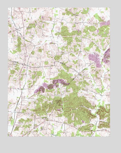
Utica, KY USGS Topographic Map
Click on map above to begin viewing in our Map Viewer.

This topographic map contains these locations and features:
Feature Name Type Latitude Longitude GNIS ID View Map
Atherton CemeteryCemeteryN37.5384°W87.1058°486114View Map
Backbone RidgeRidgeN37.5262°W87.0375°486189View Map
Barrett HillSummitN37.5339°W87.0642°486439View Map
Bethlehem ChurchChurchN37.6064°W87.0967°487026View Map
Bigger (STOL) AirportAirportN37.6123°W87.0564°517497View Map
Briarfield (historical)Populated PlaceN37.5335°W87.0643°2743110View Map
Buck Creek Baptist ChurchChurchN37.5459°W87.1085°488218View Map
Cambron Field (historical)AirportN37.5645°W87.0819°517457View Map
Daviess County Fire Department UticaBuildingN37.6077°W87.1063°2636635View Map
Greenbrier ChurchChurchN37.5803°W87.0579°493315View Map
Hanley BranchStreamN37.5017°W87.0656°493688View Map
HeflinPopulated PlaceN37.5067°W87.0069°508217View Map
Liberty SchoolSchoolN37.5462°W87.1108°496390View Map
LiviaPopulated PlaceN37.5709°W87.1044°508481View Map
MaxwellPopulated PlaceN37.5614°W87.0375°508568View Map
New Bethel ChurchChurchN37.5453°W87.0275°499287View Map
North Fork Barnett CreekStreamN37.5298°W87.0153°499541View Map
NuckolsPopulated PlaceN37.5234°W87.1122°499630View Map
Pleasant Hill ChurchChurchN37.5171°W87.0776°500868View Map
Red HillPopulated PlaceN37.6103°W87.0417°508911View Map
Red Hill Baptist ChurchChurchN37.6174°W87.0429°501658View Map
Stillhouse BranchStreamN37.5028°W87.0711°504409View Map
TichenorPopulated PlaceN37.5458°W87.1094°2743134View Map
Tucker HollowValleyN37.5251°W87.0222°505542View Map
UticaPopulated PlaceN37.6023°W87.1131°505928View Map
Utica Census Designated PlaceCensusN37.6028°W87.1127°2629697View Map
WBKR-FM (Owensboro)TowerN37.6081°W87.0542°518000View Map
Woodward Valley ChurchChurchN37.5075°W87.0244°507130View Map

Note: Coordinates in the location and feature list above are referenced to NAD83 datum.


Copyright (C) 2008-2025 Ryan Niemi / Sunset Dynamics ... All Rights Reserved