TopoQuest Logo
Do you find TopoQuest useful?
Help keep TopoQuest running and adding new maps/features by donating!
Bitcoin:  19c7KJd3qBynnjoSw5npx9KScwjBe4ifkT
Litecoin:  LXs6TkuXGGXo1vDsWCkWVdjQX94eUKd6ui
Home View Maps Find Maps Find Places Resources & Links


Pleasant Ridge, Kentucky Topographic Map

USGS Map Title: Pleasant Ridge, KY
USGS Map MRC: 37086E8
DRG (GeoTIFF) Download: o37086e8.tif


Neighboring USGS Topographic Map Quads:


  Sutherland, KY  
37087F1
 

  Philpot, KY  
37086F8
 

  Whitesville, KY  
37086F7
 

  Utica, KY  
37087E1
 

  Pleasant Ridge, KY  
37086E8
 

  Dundee, KY  
37086E7
 

  Equality, KY  
37087D1
 

  Hartford, KY  
37086D8
 

  Horton, KY  
37086D7


Map MRC Location:

N38°
W87°
N38°
W86°
H8 H7 H6 H5 H4 H3 H2 H1
G8 G7 G6 G5 G4 G3 G2 G1
F8 F7 F6 F5 F4 F3 F2 F1
E8 E7 E6 E5 E4 E3 E2 E1
D8 D7 D6 D5 D4 D3 D2 D1
C8 C7 C6 C5 C4 C3 C2 C1
B8 B7 B6 B5 B4 B3 B2 B1
A8 A7 A6 A5 A4 A3 A2 A1
N37°
W87°
N37°
W86°

Pleasant Ridge, KY USGS 1:24K Topographic Map Preview:
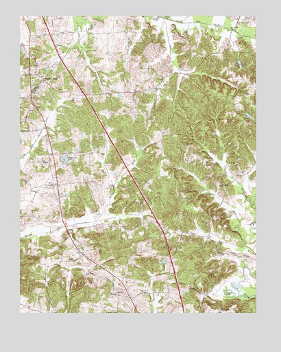
Pleasant Ridge, KY USGS Topographic Map
Click on map above to begin viewing in our Map Viewer.

This topographic map contains these locations and features:
Feature Name Type Latitude Longitude GNIS ID View Map
Ashley CemeteryCemeteryN37.5592°W86.8825°486098View Map
Barnett Creek ChurchChurchN37.5470°W86.9339°486407View Map
Bear RunStreamN37.5298°W86.8797°486573View Map
BedaPopulated PlaceN37.5078°W86.9494°507472View Map
Bell RunStreamN37.6053°W86.9180°486797View Map
Bells RunPopulated PlaceN37.5950°W86.9283°507488View Map
Beulah Cumberland Presbyterian ChurchChurchN37.5081°W86.9478°487053View Map
BufordPopulated PlaceN37.5642°W86.9839°507614View Map
Clear Run ChurchChurchN37.5378°W86.9003°489645View Map
Crooked PondLakeN37.5098°W86.8886°490389View Map
Daviess County Fire Department Masonville 2BuildingN37.6122°W86.9955°2637045View Map
Deserter CreekStreamN37.6245°W86.9247°490828View Map
Dodson CemeteryCemeteryN37.5667°W86.9558°490962View Map
Greasy CreekStreamN37.6234°W86.9217°493230View Map
Heflin-Beda DivisionCivilN37.5495°W86.9451°1937056View Map
Hoover HillSummitN37.5303°W86.9755°494514View Map
LebanonChurchN37.5003°W86.9486°498750View Map
Maple Leaf LakeReservoirN37.5646°W86.9764°497515View Map
Mount Carmel ChurchChurchN37.5542°W86.9819°498705View Map
Mount Moriah ChurchChurchN37.5634°W86.8855°498782View Map
New Panther Creek ChurchChurchN37.6217°W86.8842°499377View Map
Parks RidgeRidgeN37.5250°W86.8875°500201View Map
Pleasant RidgePopulated PlaceN37.5984°W86.9872°500888View Map
Shown CemeteryCemeteryN37.5256°W86.9672°503464View Map
TaffyPopulated PlaceN37.5539°W86.8917°504917View Map
Union Grove ChurchChurchN37.5712°W86.9117°505798View Map
Washington ChurchChurchN37.5103°W86.9072°506247View Map
Whoopee HillSummitN37.5039°W86.9014°506705View Map

Note: Coordinates in the location and feature list above are referenced to NAD83 datum.


Copyright (C) 2008-2024 Ryan Niemi / Sunset Dynamics ... All Rights Reserved