TopoQuest Logo
Do you find TopoQuest useful?
Help keep TopoQuest running and adding new maps/features by donating!
Bitcoin:  19c7KJd3qBynnjoSw5npx9KScwjBe4ifkT
Litecoin:  LXs6TkuXGGXo1vDsWCkWVdjQX94eUKd6ui
Home View Maps Find Maps Find Places Resources & Links


Hartsville, Indiana Topographic Map

USGS Map Title: Hartsville, IN
USGS Map MRC: 39085C6
DRG (GeoTIFF) Download: o39085c6.tif


Neighboring USGS Topographic Map Quads:


  Lewis Creek, IN  
39085D7
 

  Waldron, IN  
39085D6
 

  Adams, IN  
39085D5
 

  Hope, IN  
39085C7
 

  Hartsville, IN  
39085C6
 

  Forest Hill, IN  
39085C5
 

  Elizabethtown, IN  
39085B7
 

  Grammer, IN  
39085B6
 

  Westport, IN  
39085B5


Map MRC Location:

N40°
W86°
N40°
W85°
H8 H7 H6 H5 H4 H3 H2 H1
G8 G7 G6 G5 G4 G3 G2 G1
F8 F7 F6 F5 F4 F3 F2 F1
E8 E7 E6 E5 E4 E3 E2 E1
D8 D7 D6 D5 D4 D3 D2 D1
C8 C7 C6 C5 C4 C3 C2 C1
B8 B7 B6 B5 B4 B3 B2 B1
A8 A7 A6 A5 A4 A3 A2 A1
N39°
W86°
N39°
W85°

Hartsville, IN USGS 1:24K Topographic Map Preview:
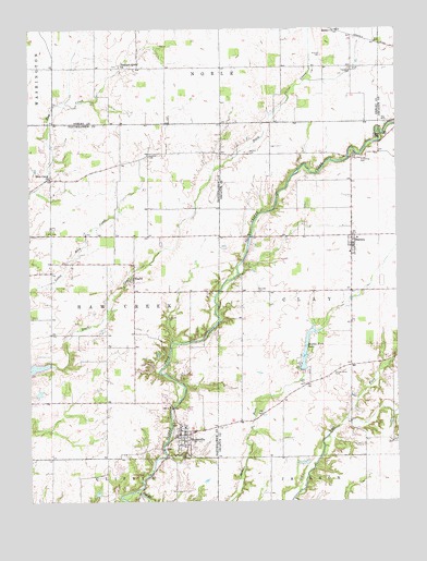
Hartsville, IN USGS Topographic Map
Click on map above to begin viewing in our Map Viewer.

This topographic map contains these locations and features:
Feature Name Type Latitude Longitude GNIS ID View Map
Bethel ChurchChurchN39.3748°W85.6450°430925View Map
BurneyPopulated PlaceN39.3173°W85.6403°431853View Map
Burney - Clay Township Volunteer Fire DepartmentBuildingN39.3198°W85.6382°2625817View Map
Camp CliftyParkN39.3464°W85.6294°432018View Map
Center Grove CemeteryCemeteryN39.2837°W85.6466°432330View Map
Copeland CemeteryCemeteryN39.3647°W85.6403°432952View Map
Fall ForkStreamN39.2526°W85.7144°434377View Map
Fletcher CemeteryCemeteryN39.3416°W85.7092°434589View Map
Galbraith CemeteryCemeteryN39.2987°W85.7039°434919View Map
HartsvillePopulated PlaceN39.2676°W85.6980°435839View Map
Hartsville College CemeteryCemeteryN39.2624°W85.6970°435840View Map
Hartsville Volunteer Fire DepartmentBuildingN39.2682°W85.6981°2625740View Map
Haw Creek ChurchChurchN39.3356°W85.7428°435895View Map
Jones CemeteryCemeteryN39.3647°W85.6396°437080View Map
Middle Fork LakeReservoirN39.2899°W85.6560°439103View Map
Middle Fork Lake DamDamN39.2851°W85.6566°448665View Map
Mitchell CemeteryCemeteryN39.3681°W85.6501°439293View Map
Nauvoo CemeteryCemeteryN39.3420°W85.6750°439951View Map
Pleasant Grove ChurchChurchN39.3653°W85.7191°441258View Map
Pumphrey CemeteryCemeteryN39.3404°W85.6379°441642View Map
RugbyPopulated PlaceN39.3092°W85.7147°442384View Map
Schultz LakeReservoirN39.2520°W85.7278°448593View Map
Schultz Lake DamDamN39.2517°W85.7266°448594View Map
Swinney CemeteryCemeteryN39.3055°W85.6728°444498View Map
Town of HartsvilleCivilN39.2670°W85.6992°2396990View Map
Township of Haw CreekCivilN39.3059°W85.7426°453403View Map
Winterrow Post Office (historical)Post OfficeN39.3645°W85.6561°453005View Map

Note: Coordinates in the location and feature list above are referenced to NAD83 datum.


Copyright (C) 2008-2025 Ryan Niemi / Sunset Dynamics ... All Rights Reserved