TopoQuest Logo
Do you find TopoQuest useful?
Help keep TopoQuest running and adding new maps/features by donating!
Bitcoin:  19c7KJd3qBynnjoSw5npx9KScwjBe4ifkT
Litecoin:  LXs6TkuXGGXo1vDsWCkWVdjQX94eUKd6ui
Home View Maps Find Maps Find Places Resources & Links


Westport, Indiana Topographic Map

USGS Map Title: Westport, IN
USGS Map MRC: 39085B5
DRG (GeoTIFF) Download: o39085b5.tif


Neighboring USGS Topographic Map Quads:


  Hartsville, IN  
39085C6
 

  Forest Hill, IN  
39085C5
 

  Greensburg, IN  
39085C4
 

  Grammer, IN  
39085B6
 

  Westport, IN  
39085B5
 

  Millhousen, IN  
39085B4
 

  North Vernon, IN  
39085A6
 

  Butlerville, IN  
39085A5
 

  Holton, IN  
39085A4


Map MRC Location:

N40°
W86°
N40°
W85°
H8 H7 H6 H5 H4 H3 H2 H1
G8 G7 G6 G5 G4 G3 G2 G1
F8 F7 F6 F5 F4 F3 F2 F1
E8 E7 E6 E5 E4 E3 E2 E1
D8 D7 D6 D5 D4 D3 D2 D1
C8 C7 C6 C5 C4 C3 C2 C1
B8 B7 B6 B5 B4 B3 B2 B1
A8 A7 A6 A5 A4 A3 A2 A1
N39°
W86°
N39°
W85°

Westport, IN USGS 1:24K Topographic Map Preview:
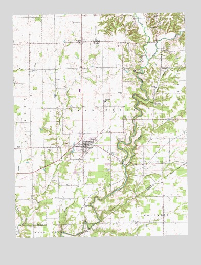
Westport, IN USGS Topographic Map
Click on map above to begin viewing in our Map Viewer.

This topographic map contains these locations and features:
Feature Name Type Latitude Longitude GNIS ID View Map
Burks Chapel CemeteryCemeteryN39.2293°W85.5131°431840View Map
Cobbs ForkStreamN39.2242°W85.5269°432722View Map
Eddleman CemeteryCemeteryN39.1567°W85.5986°433998View Map
Finley CemeteryCemeteryN39.2177°W85.5947°434488View Map
Freedonia ChurchChurchN39.1431°W85.5747°434810View Map
Friendship ChurchChurchN39.1992°W85.5233°434864View Map
GaynorsvillePopulated PlaceN39.2428°W85.5200°435000View Map
HarperPopulated PlaceN39.1467°W85.5936°435761View Map
Horseshoe Bend CemeteryCemeteryN39.1796°W85.5497°436492View Map
Ice CreekStreamN39.1303°W85.5705°436700View Map
Ice Creek ChurchChurchN39.1326°W85.5377°436701View Map
LettsPopulated PlaceN39.2351°W85.5650°437794View Map
Letts Community Volunteer Fire DepartmentBuildingN39.2438°W85.5206°2701450View Map
Letts CornerPopulated PlaceN39.2348°W85.5750°437795View Map
Letts Fire DepartmentBuildingN39.2352°W85.5647°2625874View Map
Lower Union Presbyterian CemeteryCemeteryN39.2189°W85.6122°438375View Map
Mapleton CemeteryCemeteryN39.2052°W85.5460°438582View Map
Mapleton CornerPopulated PlaceN39.1909°W85.5461°438583View Map
Millstone CreekStreamN39.1278°W85.5914°439247View Map
Mount Aerie ChurchChurchN39.2345°W85.5769°439518View Map
Neff CornerPopulated PlaceN39.1653°W85.5322°439981View Map
Panther CreekStreamN39.1637°W85.5452°441006View Map
PinhookPopulated PlaceN39.2195°W85.5175°441167View Map
Poplar Root CreekStreamN39.1289°W85.6233°441450View Map
Rock CreekStreamN39.1334°W85.5641°442192View Map
Rock Creek ChurchChurchN39.1653°W85.5180°442199View Map
Rodney BranchStreamN39.2001°W85.5347°442240View Map
Rodney CemeteryCemeteryN39.1996°W85.5232°442241View Map
Rodney ChurchChurchN39.2084°W85.5222°442242View Map
Town of WestportCivilN39.1772°W85.5751°2397736View Map
Township of SandcreekCivilN39.2080°W85.5596°453832View Map
Turnover CreekStreamN39.1326°W85.6230°444994View Map
Wesley CemeteryCemeteryN39.1755°W85.6208°445690View Map
WestportPopulated PlaceN39.1759°W85.5730°445857View Map
Westport CemeteryCemeteryN39.1741°W85.5977°445858View Map
Westport Community Volunteer Fire DepartmentBuildingN39.1780°W85.5725°2625771View Map
Westport Police DepartmentBuildingN39.1766°W85.5741°2758332View Map

Note: Coordinates in the location and feature list above are referenced to NAD83 datum.


Copyright (C) 2008-2025 Ryan Niemi / Sunset Dynamics ... All Rights Reserved